Ouvrage Boussois is a petit ouvrage of the Maginot Line, built as part of the "New Fronts" program to address shortcomings in the Line's coverage of the border with Belgium. Like the other three ouvrages near Maubeuge, it is built on an old Séré de Rivières fortification, near the town of Boussois. The fortification surrendered to the Germans twice, in the First World War on 6 September 1914, and in the Second World War on 22 May 1940. The site is now abandoned.

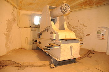
Ouvrage Janus is a work of the Maginot Line's Alpine extension, the Alpine Line, located to the east of Briançon on near the Col de Montgenèvre. The ouvrage consists of one entry block, two infantry blocks, two artillery blocks, two observation blocks and one combination block at an altitude of 2,540 metres (8,330 ft), the second highest fortification on the Alps in 1940. Built on the site of the old Fort Janus, it retained the old fort's 95mm naval guns and added two 75mm guns
Ouvrage Barbonnet is a work of the Maginot Line's Alpine extension, the Alpine Line, also called the Little Maginot Line. The ouvrage consists of one entry block and one infantry block facing Italy. The ouvrage was built somewhat behind the main line of fortifications on the old Fort Suchet, which was already armed with two obsolete Mougin 155 mm gun turrets.

Fort du Salbert, also known as Fort Lefebvre, was built between 1874 and 1877. It was named after General François Joseph Lefebvre. It forms part of the Séré de Rivières system fortifications in the fortified region of Belfort in northeastern France. It is located at the summit of Salbert hill to the northwest of Belfort. During the early years of the Cold War it briefly served as an air defense coordination center.
Fort de Roppe, also known as Fort Ney, was built between 1875 and 1877. It is part of the second ring of fortifications around the city of Belfort in northeastern France. This set of forts was built as part of the Séré de Rivières system and incorporated improvements to deal with the improvement in efficacy of artillery in the late 19th century.

Fort Bois d'Oye, also known as Fort Eblé, is located in the commune of Bermont. It was built between 1883 and 1886. It is part of the second ring of fortifications around the city of Belfort in northeastern France. This second ring of forts was built as part of the Séré de Rivières system and incorporated improvements to deal with the improvement in efficacy of artillery in the late 19th century.

Fort des Basses Perches, also known as Fort Valmy, was built between 1874 and 1877 in Danjoutin and Belfort in northeastern France. It is part of the first ring of fortifications around the city of Belfort. The Forts des Perches were unique among the first group in their re-use of older sites. They were rebuilt as part of the Séré de Rivières system and incorporated improvements to deal with the improvement in efficacy of artillery in the late 19th century. The fort's official name was derived from François-Christophe Kellermann, Duke of Valmy and Marshal of France.

Fort des Hautes Perches was built between 1874 and 1877 in Danjoutin and Belfort in northeastern France. It is part of the first ring of fortifications around the city of Belfort. The Forts des Perches were unique among the first group in their re-use of older sites. They were rebuilt as part of the Séré de Rivières system and incorporated improvements to deal with the improvement in efficacy of artillery in the late 19th century.

Fort de Vézelois, also known as Fort Ordener, was built between 1883 and 1886 near Vézelois, to the southeast of Belfort in northeastern France. It is part of the first ring of fortifications around the city of Belfort. It is part of the second ring of fortifications around the city of Belfort in northeastern France. This set of forts was built as part of the Séré de Rivières system and incorporated improvements to deal with the improvement in efficacy of artillery in the late 19th century. The fort was formally named after French General Michel Ordener.
Fort de Giromagny, also known as Fort Dorsner, was built near Belfort in northeastern France between 1875 and 1879. The fort forms the southern end of the defensive curtain of the Haute Moselle Region, abutting the fortified region of Belfort, which lies to its south. The Haute Moselle defenses form a link between the fortified encampments of Épinal and Belfort. The fort overlooks the main roads to the northeast of Belfort, which form a crossroads at Giromagny.

The Fort de Saint-Cyr, located in the commune of Montigny-le-Bretonneux, (Yvelines), is one of the forts built at the end of the 19th century to defend Paris. After the first world war the fort was used as an army weather station and arms depot. Classed in 1992 as a monument historique, it is now used as a film depository for the preservation of movies under the Cinémathèque française.

Fort de Villey-le-Sec, also known as Fort Trévise, is a fortification of the 19th century, built as part of the Séré de Rivières system of fortifications in Villey-le-Sec, France, one of the defenses of Toul. It is a unique example for its time of a defensive enclosure around a village. Conceived after the defeat of the Franco-Prussian War of 1870-71, the fort was located away from the main combat zone of World War I and has remained almost intact. The fort's preservation association has been at work since 1961 to restore and interpret the site. It has been included in the Inventory of Historic Sites and has been designated as a preserved natural area.

The Fort de Vaujours, located in the commune of Courtry, Seine-Saint-Denis, near the town of Vaujours, is one of the forts built at the end of the 19th century to defend Paris. It became a research center for the Commissariat à l'énergie atomique (CEA), France's Atomic Energy Commission. The center was closed in 1997.

The Fort de Liouville, also known as Fort Stengel, located between the communes of Saint-Agnant-sous-les-Côtes and Saint-Julien-sous-les-Côtes, near the town of Commercy in the Meuse departement of France, is one of the forts built at the end of the 19th century to defend the valley of the Meuse. The fort was located on what was then the French frontier facing the German-occupied province of Lorraine. The Fort de Liouville was located between the Fort de Gironville and the Camp des Romains.

The Fort du Replaton is a fortification of the Séré de Rivières system in Modane, France. The fort was built to provide artillery cover for the French end of the Fréjus Rail Tunnel 800 metres (2,600 ft) away horizontally. It is connected to Modane by an aerial tram, which continues on from Replaton to the Fort du Sapey on a much higher eminence.

Fort du Mont Bart is located to the south of Montbéliard, France. It was built between November 1874 and July 1877 as part of the Séré de Rivières system of fortifications. The fort overlooks the valleys of the Doubs and the Allan at an elevation of 497 metres (1,631 ft), standing to the south and rear of the fortified region of Belfort and in control of the road to Besançon. The fort was intended to augment the Belfort fortifications and to prevent an enemy from bypassing them. The most striking feature of the Fort du Mont Bart is its "interior street", originally constructed in the open air as a sunken court, then covered before World War I with reinforced concrete.
The Fort d'Uxegney, or Fort Roussel, is part of the fortifications of Épinal. It was built near the village of Uxegney between 1882 and 1884, and was modernized in 1910. It is an example of a Séré de Rivières system fortification. It retains its armament and is maintained as a museum.

The Fort des Adelphes, or Fort Richepance, is part of the fortifications of Épinal. It was built near the village of Deyvillers between 1883 and 1885, and was modernized beginning in 1907. It is an example of a Séré de Rivières system fortification. During World War II the fort surrendered to German forces and was then used by the Germans to fire on neighboring forts Longchamp and Dogneville. The fort is now occupied by an activity of the French Air Force associated with Base aerienne 133 Nancy-Ochey and is not accessible to the public.

The Fort des Ayvelles, also known as the Fort Dubois-Crancé, is a fortification near the French communes of Villers-Semeuse and Les Ayvelles in the Ardennes, just to the south of Charleville-Mézières. As part of the Séré de Rivières system of fortifications, the fort was planned as part of a new ring of forts replacing the older citadel of Mézières with dispersed fortifications. With advances in the range and destructive power of artillery, the city's defensive perimeter had to be pushed away from the city center to the limits of artillery range. The Fort des Ayvelles was the only such fortification to be completed of the ensemble, as resources were diverted elsewhere. At the time of its construction the fort controlled the Meuse and the railway line linking Reims, Montmédy, Givet and Hirson. The Fort des Ayvelles was reduced in status in 1899, its masonry construction rendered obsolete by the advent of high-explosive artillery shells. However, it was re-manned for the First World War before it was captured by the Germans on 29 August 1914. The fort was partly destroyed in 1918. During the Battle of France in 1940 the fort was bombarded. French resisters were executed at Ayvelles during both world wars. At present the fort is maintained by a preservation society, and may be visited.

The Fort de Bourlémont, or Fort Choiseul, was built between 1878 and 1881. The fort was built as part of the Séré de Rivières system of fortifications, which were conceived in response to the increasing power and range of artillery. The Fort de Bourlémont was part of the defenses of the Charmes Gap, in the town of Mont-lès-Neufchâteau, 3 kilometres (1.9 mi) west of Neufchâteau.