
The National Redoubt was a strategic defensive belt of fortifications built in Belgium. The National redoubt was the infrastructural cornerstone of Belgian defensive strategy from 1890–1940.
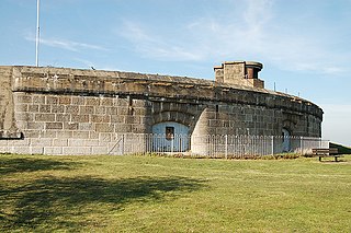
Coalhouse Fort is an artillery fort in the eastern English county of Essex. It was built in the 1860s to guard the lower Thames from seaborne attack. It stands at Coalhouse Point on the north bank of the river, at a location near East Tilbury which was vulnerable to raiders and invaders. It was the last in a series of fortifications dating back to the 15th century and was the direct successor to a smaller mid-19th century fort built on the same site. Constructed during a period of tension with France, its location on marshy ground caused problems from the start and led to a lengthy construction process. The fort was equipped with a variety of large-calibre artillery guns and the most modern defensive facilities of the time, including shell-proof casemates protected by granite facing and cast-iron shields. Its lengthy construction and the rapid pace of artillery development at the time meant that it was practically obsolete for its original purpose within a few years of its completion.


Ouvrage Boussois is a petit ouvrage of the Maginot Line, built as part of the "New Fronts" program to address shortcomings in the Line's coverage of the border with Belgium. Like the other three ouvrages near Maubeuge, it is built on an old Séré de Rivières fortification, near the town of Boussois. The fortification surrendered to the Germans twice, in the First World War on 6 September 1914, and in the Second World War on 22 May 1940. The site is now abandoned.
Ouvrage Barbonnet is a work of the Maginot Line's Alpine extension, the Alpine Line, also called the Little Maginot Line. The ouvrage consists of one entry block and one infantry block facing Italy. The ouvrage was built somewhat behind the main line of fortifications on the old Fort Suchet, which was already armed with two obsolete Mougin 155mm gun turrets.

The Séré de Rivières system was an ensemble of fortifications built from 1874 along the frontiers, ridges and coasts of France. The fortifications were named after their architect, Brigadier-General Raymond Adolphe Séré de Rivières. The fortresses were obsolescent by 1914 but were used during the First World War.

The Batterie de Bouviers is located in the commune of Guyancourt, Yvelines, France. It is a former fortification built beginning in 1879 and occupied by the army until 1932. From 1933 it was leased by the Hispano Suiza company as a factory, surrounded by other industrial structures. The site was abandoned by Hispano Suiza in 1990, and was sold by the Ministry of Defense in 1999. In 2006 the battery became the "Cafe Musiques", surrounded by office buildings and a music school.
Fort de Champigny was built following the Franco-Prussian War to defend Paris. Located to the southeast of Paris in Chennevières-sur-Marne, the fort was part of an outer ring of fortifications built in response to improvements in the range and effectiveness of artillery since the construction of the Thiers fortifications of the 1840s. It was built in accordance with improved principles of fortification developed for the Séré de Rivières system.

Fort de Villey-le-Sec, also known as Fort Trévise, is a fortification of the 19th century, built as part of the Séré de Rivières system of fortifications in Villey-le-Sec, France, one of the defenses of Toul. It is a unique example for its time of a defensive enclosure around a village. Conceived after the defeat of the Franco-Prussian War of 1870-71, the fort was located away from the main combat zone of World War I and has remained almost intact. The fort's preservation association has been at work since 1961 to restore and interpret the site. It has been included in the Inventory of Historic Sites and has been designated as a preserved natural area.

The Fort de Liouville, also known as Fort Stengel, located between the communes of Saint-Agnant-sous-les-Côtes and Saint-Julien-sous-les-Côtes, near the town of Commercy in the Meuse departement of France, is one of the forts built at the end of the 19th century to defend the valley of the Meuse. The fort was located on what was then the French frontier facing the German-occupied province of Lorraine. The Fort de Liouville was located between the Fort de Gironville and the Camp des Romains.

The Fort du Bruissin is a fort in Francheville, France, near the city of Lyon. Built between 1878 and 1881, the fort is part of the Séré de Rivières system of fortifications built in the late 19th century. It has been rehabilitated as a contemporary artists' community. The Fort en Jazz festival is held there each year.
The Fort de Châtillon was a fortification located about 5 kilometres (3.1 mi) south of Paris in the communes of Châtillon-sous-Bagneux and Fontenay-aux-Roses. It was built in 1874 and was razed beginning in 1957, making way for expansion of the French nuclear research facility at Fontenay-aux-Roses.

The Fort de Maulde, also known as Fort de Beurnonville and the Ensemble de Maulde, is located to the south of Maulde, France. It is part of the Fortified Sector of the Escaut, an extension of the Maginot Line. The Séré de Rivières system fort was built 1881–1884. In 1936–1937 the old fort, commanding high ground behind Maulde, was altered for more modern fortifications. It was evacuated by its garrison in 1940 during the Battle of France as part of the French retreat from the border with Belgium.

The Fort des Ayvelles, also known as the Fort Dubois-Crancé, is a fortification near the French communes of Villers-Semeuse and Les Ayvelles in the Ardennes, just to the south of Charleville-Mézières. As part of the Séré de Rivières system of fortifications, the fort was planned as part of a new ring of forts replacing the older citadel of Mézières with dispersed fortifications. With advances in the range and destructive power of artillery, the city's defensive perimeter had to be pushed away from the city center to the limits of artillery range. The Fort des Ayvelles was the only such fortification to be completed of the ensemble, as resources were diverted elsewhere. At the time of its construction the fort controlled the Meuse and the railway line linking Reims, Montmédy, Givet and Hirson. The Fort des Ayvelles was reduced in status in 1899, its masonry construction rendered obsolete by the advent of high-explosive artillery shells. However, it was re-manned for the First World War before it was captured by the Germans on 29 August 1914. The fort was partly destroyed in 1918. During the Battle of France in 1940 the fort was bombarded. French resisters were executed at Ayvelles during both world wars. At present the fort is maintained by a preservation society, and may be visited.

The Fort de Bourlémont, or Fort Choiseul, was built between 1878 and 1881. The fort was built as part of the Séré de Rivières system of fortifications, which were conceived in response to the increasing power and range of artillery. The Fort de Bourlémont was part of the defenses of the Charmes Gap, in the town of Mont-lès-Neufchâteau, 3 kilometres (1.9 mi) west of Neufchâteau.
The Fort de Condé, or Fort Pille, is a fortification of the Séré de Rivières system, built in France between 1877 and 1883 to defend the area between Soissons and Laon. It is located on the heights of the confluence of the Aisne and the Vesle near the communes of Condé-sur-Aisne and Chivres-Val. Although the fort was considered obsolete at the start of World War I, its command of strategic ground made it a coveted objective throughout the war, changing hands several times. Following the war it was used in support service before its abandonment and purchase by a local community. It has been under preservation since 1979 and may be visited.
The Fort de Montmorency was built following the Franco-Prussian War to defend Paris. Located to the north of Paris in Montmorency, the fort was part of an outer ring of fortifications built in response to improvements in the range and effectiveness of artillery since the construction of the Thiers fortifications of the 1840s. It was built between 1875 and 1879 in accordance with improved principles of fortification developed for the Séré de Rivières system.

The Fort de Cormeilles-en-Parisis was constructed between 1874 and 1877 as part of a new plan for the defense of Paris developed by General Raymond Adolphe Séré de Rivières, near the town of Cormeilles-en-Parisis. During the Franco-Prussian War, German troops had used the hill upon which the fort sits as a spotting and firing location, ideal for the siting of new rifled guns whose range was increased over old-fashioned smooth-bore guns. These weapons could attack Paris from Cormeilles, so a new outer ring of forts had to be built outside the first ring of forts built in 1840–1860 to deny the area to enemy gunners. The Séré de Rivières system was designed as a response to these technological innovations, and to the loss of French territories in Alsace and Lorraine.
A polygonal fort is a type of fortification originating in France in the late 18th century and fully developed in Germany in the first half of the 19th century. Unlike earlier forts, polygonal forts had no bastions, which had proved to be vulnerable. As part of ring fortresses, polygonal forts were generally arranged in a ring around the place they were intended to protect, so that each fort could support its neighbours. The concept of the polygonal fort proved to be adaptable to improvements in the artillery which might be used against them, and they continued to be built and rebuilt well into the 20th century.

