Fort Douaumont

Last updated
Forts around Verdun. Douaumont is north-east of Verdun at upper right. Limits of German advance as at 26 February and 6 September 1916 are black lines, the river Meuse, flowing to the north, is the blue line at left. Fort Douaumont location map 300px.jpg
Forts around Verdun. Douaumont is north-east of Verdun at upper right. Limits of German advance as at 26 February and 6 September 1916 are black lines, the river Meuse, flowing to the north, is the blue line at left.

Fort Douaumont (French : Fort de Douaumont) was the largest and highest fort on the ring of 19 large defensive works which had protected the city of Verdun, France, since the 1890s. By 1915, the French General Staff had concluded that even the best-protected forts of Verdun could not withstand bombardments from the German 420 mm (16.5 in) Gamma guns. These new super-heavy howitzers had easily taken several large Belgian forts out of action in August 1914. Fort Douaumont and other Verdun forts were judged ineffective and had been partly disarmed and left virtually undefended since 1915. On 25 February 1916, Fort Douaumont was entered and occupied without a fight by a small German raiding party comprising only 19 officers and 79 men, entering via an open window by the moat. The easy fall of Fort Douaumont, only three days after the beginning of the Battle of Verdun, shocked the French Army. It set the stage for the rest of a battle which lasted nine months, at enormous human cost. Douaumont was finally recaptured by three infantry divisions of the Second Army, during the First Offensive Battle of Verdun on 24 October 1916. This event brought closure to the battle in 1916. [1]

Contents

History

Aerial view early in 1916 before major destruction in the Battle of Verdun. North is approximately at top Douaumontfort.jpg
Aerial view early in 1916 before major destruction in the Battle of Verdun. North is approximately at top

Construction work started in 1885 near the village of Douaumont, on some of the highest ground in the area and the fort was continually reinforced until 1913. It has a total surface area of 30,000 m2 (36,000 sq yd) and is approximately 400 m (440 yd) long, with two subterranean levels protected by a steel reinforced concrete roof 12 m (13 yd) thick resting on a sand cushion. These improvements had been completed by 1903. The entrance to the fort was at the rear. Two main tunnels ran east–west, one above the other, with barrack rooms and corridors to outlying parts of the fort branched off of the main tunnels. [2] The fort was equipped with numerous armed posts, a 155 mm rotating/retractable gun turret, a 75 mm gun rotating/retractable gun turret, four other 75 mm guns in flanking "Bourges Casemates" that swept the intervals and several machine-gun turrets. [2] Entry into the moat around the fort was interdicted by Hotchkiss anti-personnel revolving cannons located in wall casemates or "Coffres" present at each corner. [2]

With hindsight, Douaumont was much better prepared to withstand the heaviest bombardments than the Belgian forts that had been crushed by German 420 mmGamma howitzers in 1914. The German invasion of Belgium in 1914 had forced military planners to radically rethink the utility of fortification in war. The Belgian forts had been quickly destroyed by German artillery and easily overrun. However, the Belgian forts were built with unreinforced concrete, with many layers that easily broke apart. In August 1915, General Joseph Joffre approved the reduction of the garrison at Douaumont and at other Verdun forts. Douaumont was stripped of all its weaponry except for the two turreted guns that were too difficult to remove: a 155 mm and a 75 mm gun. The two "Casemates de Bourges" bunkers, one on each side of the fort, were disarmed of their four 75s. [2] The garrison was mostly middle-aged reservists, under the command of the city's military governor and not the field army. [2]

Capture

Main communication passage, Fort Douaumont Main communication passage, Fort Douaumont.jpg
Main communication passage, Fort Douaumont
Captain Hans-Joachim Haupt, Lieutenant-Colonel von Oven, Captain Cordt von Brandis OffiziereHauptOvenBrandis.jpg
Captain Hans-Joachim Haupt, Lieutenant-Colonel von Oven, Captain Cordt von Brandis

On 21 February 1916, the German 5th Army began an offensive which started the Battle of Verdun. Douaumont was the largest and highest fort on the two concentric rings of forts protecting the city and thus the keystone to the city defenses. The German offensive was already four days old and progressing rapidly from the north when, on 24 February, it came within reach of Fort Douaumont. Fort Douaumont was still only manned by a maintenance crew of only 56 troops and a few gunners. The highest-ranked soldier in the fort was an NCO named Chenot. On 25 February, elements of the German 24th Brandenburg Regiment (6 Infanterie-Division, III Armeekorps) approached Fort Douaumont from the north, as a reconnaissance or raiding party. Most of the French garrison had already gone to the lower levels of the fort to escape the incessant German shelling with large-calibre guns. A battery of super-heavy 420 mm M-Gerät howitzers was intermittently pounding the fort, damaging the 75 mm gun turret.

The occupants had been without communication with the outside world for some time. The observation cupolas were unoccupied. Only a small gunnery team was manning the 155 mm gun turret, which was firing at distant targets. The dry moats which could have been swept by French machine-gun fire from the wall "casemates" or "coffres" had been left undefended. About 10 combat engineers from the Brandenburg regiment, led by Pioneer-Sergeant Kunze, managed to approach the fort unopposed. Visibility was poor due to bad weather, and French machine gunners in the village of Douaumont thought the Germans were French colonial troops returning from a patrol. [2] Kunze and his men reached the moat and found that the wall casemates (coffres) defending the moat were unoccupied. Kunze managed to climb inside one of them to open a door. [2] Kunze's men refused to go inside the fortification, fearing an ambush. Armed only with a rifle, the Pioneer-Sergeant entered alone. [3] He wandered around the empty tunnels until he found the artillery team, captured them and locked them up. [2]

By now, another group from the Brandenburg regiment, led by reserve-officer Lieutenant Radtke, was also entering the fort through its unoccupied defences. Radtke then made contact with Kunze's troops and organised them before they spread out, capturing a few more French defenders and securing the fort. Later, more columns of German troops under Hauptmann Haupt and Oberleutnant von Brandis arrived. No shots were ever fired in the capture of Fort Douaumont. The only casualty was one of Kunze's men, who scraped a knee. Despite being the last officer to enter the fort, von Brandis was the one who dispatched the report on the capture of Douaumont to the German High Command. [2] A few days later, the Prussian officer was telling Crown Prince Wilhelm about its heroic seizure. No mention was made of the efforts of Lieutenant Radtke or Sergeant Kunze. Instead von Brandis became the "Hero of Douaumont" and was awarded the Pour le Mérite , (Haupt received it later, too). Kunze, who broke in and locked up the garrison and Radtke, who took command during the fort's capture, received no award. It was not until the 1930s, after historians from the German Great War committee had time to review the capture of Fort Douaumont that credit was belatedly given. Kunze, now a member of the Ordnungspolizei , received a promotion and the order of Pour le Mérite, while Lieutenant Radtke got an autographed portrait of former Crown Prince Wilhelm.

Douaumont, the keystone of the system of forts that was to protect Verdun against a German invasion, had been given up without a fight. In the words of one French divisional commander, its loss would cost the French army 100,000 lives. [4] Douaumont's easy fall was a disaster for the French and a glaring example of the lack of judgment prevailing in the General Staff at the time, under General Joffre. The French General Staff had decided in August 1915 to partially disarm all the Verdun forts, acting under the erroneous assumption that the forts could not resist the effects of modern heavy artillery. After its capture, Douaumont became an invulnerable shelter and operational base for German forces just behind their front line. The German soldiers at Verdun came to refer to the place as "Old Uncle Douaumont". [2]

Recapture

Aerial view towards the end of 1916, showing trenches and shell craters. North is approximately at top Fort Douaumont Ende 1916 rotated North at top.jpg
Aerial view towards the end of 1916, showing trenches and shell craters. North is approximately at top

The French Second Army made a first attempt to recapture the fort in late May 1916. They occupied the western end of the fort for 36 hours but were dislodged after suffering heavy losses, mostly from German artillery and trench mortars nearby. The Germans stubbornly held onto the fort, as it provided shelter for troops and served as first aid station and supply dump. French artillery continued to shell the fort, turning the area into a pockmarked moonscape, traces of which are still visible. On 8 May 1916, an unattended cooking fire had detonated grenades and flamethrower fuel, which detonated an ammunition cache. Apparently some of the soldiers tried to heat coffee using flamethrower fuel, which proved to be too flammable and spread to shells which were without caution placed right next to such environments. A firestorm ripped through the fort, killing hundreds of soldiers instantly, including the 12th Grenadiers regimental staff. Some of the 1,800 wounded and soot-blackened survivors attempting to escape from the inferno were mistaken for French colonial infantry and were fired upon by their comrades; 679 German soldiers perished in this fire. [5] Their remains were gathered inside the fort at the time and placed into a casemate which was walled off. The site is underground, inside the fort and has long been an official German war grave. A commemorative plaque in German and a cross stand at the foot of the grave's sealing wall. The memorial is open to visitors.

Recapture of Fort Douaumont on 24 October 1916. La reprise de Douaumont, le 24 octobre 1916.PNG
Recapture of Fort Douaumont on 24 October 1916.

A French offensive involving three infantry divisions began on 24 October 1916, to recapture the fort. This took place on the same day and was carried out by the elite Régiment d'infanterie-chars de marine (At that time designated the Régiment d'infanterie coloniale du Maroc, R.I.C.M (Regiment of Colonial Infantry of Morocco)). Douaumont had been pounded for days by two super heavy 400 mm (16 in) long-range French railway guns named "Alsace" and "Lorraine", emplaced at Baleycourt, south-west of Verdun. [6] Douaumont had become untenable under their fire and was in the process of being evacuated when it was recaptured. [2] Millions of smaller shells had been fired at the fort since its capture by the Germans to little avail and tens of thousands of men had died in attempts to recapture it.

See also

Notes

  1. "German troops capture Fort Douaumont (Verdun)". History.com.
  2. 1 2 3 4 5 6 7 8 9 10 11 Duchesneau, Robert E. "The Forts of Verdun" . Retrieved 30 January 2013.
  3. Durschmied, Erik (2003). Unsung Heroes. London: Coronet Books. pp. 5–53. ISBN   978-0-340-82520-4.
  4. Horne, Alistair (1963). The Price of Glory. New York: St. Martin's Press. p. 116. OCLC   779062916.
  5. Mosier, John. Verdun: The Lost History of the Most Important Battle of World War I, 1914–1918. Penguin Group: 2013. p. 302.[ ISBN missing ]
  6. "Historique du 77e Régiment d'Artillerie Lourde à Grande Portée" (PDF). p. 10.

Related Research Articles

<span class="mw-page-title-main">Battle of Verdun</span> Battle on the Western Front during the First World War

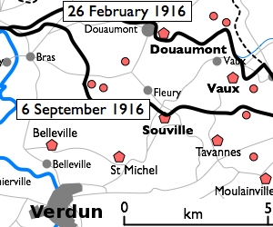
The Battle of Verdun was fought from 21 February to 18 December 1916 on the Western Front in France. The battle was the longest of the First World War and took place on the hills north of Verdun-sur-Meuse. The German 5th Army attacked the defences of the Fortified Region of Verdun and those of the French Second Army on the right (east) bank of the Meuse. Using the experience of the Second Battle of Champagne in 1915, the Germans planned to capture the Meuse Heights, an excellent defensive position, with good observation for artillery-fire on Verdun. The Germans hoped that the French would commit their strategic reserve to recapture the position and suffer catastrophic losses at little cost to the German infantry.
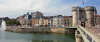
<span class="mw-page-title-main">Verdun</span> Subprefecture and commune in Grand Est, France

Verdun is a large city in the Meuse department in Grand Est, northeastern France. It is an arrondissement of the department.

<span class="mw-page-title-main">Siege of Maubeuge</span>

The siege of Maubeuge took place from 24 August – 7 September 1914, at the Entrenched Camp of Maubeuge the start of the First World War on the Western Front. The railway from Thionville to Luxembourg City, Arlon and Namur into Belgium had been cut by the demolition of the rail bridge over the Meuse at Namur in Belgium. During the siege, the German armies in the north could use only the single-track line from Trier to Liège, Brussels, Valenciennes and Cambrai, which could accommodate a maximum of forty trains a day.

<span class="mw-page-title-main">Fort Vaux</span> Fort located in Vaux-Devant-Damloup, Meuse, France

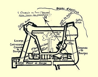
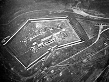
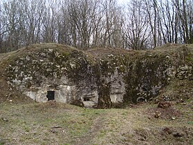
Fort Vaux, in Vaux-Devant-Damloup, Meuse, France, was a polygonal fort forming part of the ring of 19 large defensive works intended to protect the city of Verdun. Built from 1881 to 1884 for 1,500,000 francs, it housed a garrison of 150 men. Vaux was the second fort to fall in the Battle of Verdun after Fort Douaumont, which was captured by a small German raiding party in February 1916 in the confusion of the French retreat from the Woëvre plain. Vaux had been modernised before 1914 with reinforced concrete top protection like Fort Douaumont and was not destroyed by German heavy artillery fire, which had included shelling by 16-inch (410 mm) howitzers. The superstructure of the fort was badly damaged but the garrison, the deep interior corridors and stations were intact when the fort was attacked on 2 June by German Stormtroops.

<span class="mw-page-title-main">Fort Drum (Philippines)</span> Abandoned sea fort in Manila Bay

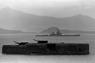
Fort Drum, also known as El Fraile Island, is a heavily fortified island situated at the mouth of Manila Bay in the Philippines, due south of Corregidor Island. Nicknamed a "concrete battleship", the reinforced concrete sea fort, shaped like a battleship, was built by the United States in 1909 as one of the harbor defenses at the wider South Channel entrance to the Bay during the American colonial period.

<span class="mw-page-title-main">Séré de Rivières system</span> Fortifications in France

The Séré de Rivières system was an ensemble of fortifications built from 1874 along the frontiers, ridges and coasts of France. The fortifications were named after their architect, Brigadier-General Raymond Adolphe Séré de Rivières. The fortresses were obsolescent by 1914 but were used during the First World War.

<span class="mw-page-title-main">Battle of Fort Ében-Émael</span> Battle (WW2)

The Battle of Fort Ében-Émael was a battle between Belgian and German forces that took place between 10 May and 11 May 1940, and was part of the Battle of Belgium and Fall Gelb, the German invasion of the Low Countries and France. An assault force of German paratroopers, Fallschirmjäger, was tasked with assaulting and capturing Fort Ében-Émael, a Belgian fortress whose strategic position and strong artillery emplacements dominated several important bridges over the Albert Canal. These carried roads which led into the Belgian heartland and were what the German forces intended to use to advance. As some of the German airborne forces assaulted the fortress and disabled the garrison and the artillery pieces inside it, others simultaneously captured three bridges over the Canal. Having disabled the fortress, the airborne troops were then ordered to protect the bridges against Belgian counter-attacks until they linked up with ground forces from the German 18th Army.

<span class="mw-page-title-main">French Army in World War I</span>

During World War I, France was one of the Triple Entente powers allied against the Central Powers. Although fighting occurred worldwide, the bulk of the French Army's operations occurred in Belgium, Luxembourg, France and Alsace-Lorraine along what came to be known as the Western Front, which consisted mainly of trench warfare. Specific operational, tactical, and strategic decisions by the high command on both sides of the conflict led to shifts in organizational capacity, as the French Army tried to respond to day-to-day fighting and long-term strategic and operational agendas. In particular, many problems caused the French high command to re-evaluate standard procedures, revise its command structures, re-equip the army, and to develop different tactical approaches.

<span class="mw-page-title-main">Fort de Liouville</span>


The Fort de Liouville, also known as Fort Stengel, located between the communes of Saint-Agnant-sous-les-Côtes and Saint-Julien-sous-les-Côtes, near the town of Commercy in the Meuse departement of France, is one of the forts built at the end of the 19th century to defend the valley of the Meuse. The fort was located on what was then the French frontier facing the German-occupied province of Lorraine. The Fort de Liouville was located between the Fort de Gironville and the Camp des Romains.

<span class="mw-page-title-main">Ouvrage La Ferté</span> Ouvrage in Maginot Line, Ardennes, France

Ouvrage La Ferté, also known as Ouvrage Villy-La Ferté, is a petit ouvrage of the Maginot Line, located in the Fortified Sector of Montmédy, facing Belgium. The ouvrage lies between the towns of Villy and La Ferté-sur-Chiers. It possesses two combat blocks linked by an underground gallery. The westernmost position in its sector, it was a comparatively weakly armed fortification in an exposed position that left it vulnerable to isolation and attack. After a sustained attack during the Battle of France, the position was overwhelmed by German forces and was destroyed with its entire garrison killed. The fighting at La Ferté was the heaviest of any position in the Maginot Line. It is preserved as a war memorial.

<span class="mw-page-title-main">Fortified Sector of Montmédy</span>

The Fortified Sector of Montmédy was the French military organisation that in 1940 controlled the section of the Maginot Line between Sedan and Longuyon, a distance of about 60 kilometres (37 mi). The sector was not as strongly defended as other sections of the Maginot Line, facing the southern Ardennes region of Belgium. Large portions of the Montmédy sector were defended by fortified houses, blockhouses or casemates. The sector includes only four ouvrages of the type found in stronger sections of the Line. The weakly defended area in front of Sedan was the scene of a major breakthrough by German forces in the opening of the Battle of France. This was followed by a German assault on the Maginot Ouvrage La Ferté, which killed the entire garrison, the only such event on the Maginot Line.

<span class="mw-page-title-main">Fort de Barchon</span> 19th-20th century defence for Liège, Belgium

The Fort de Barchon is one of twelve forts built around Liège, Belgium, in the late 19th century. The overall Fortified Position of Liège was a constituent part of the country's National Redoubt. Fort de Barchon was built between 1881 and 1884 according to the plans of General Henri Alexis Brialmont. Contrasting with the French forts built in the same era by Raymond Adolphe Séré de Rivières, the fort was built exclusively of unreinforced concrete, a new material, rather than masonry. The fort was heavily bombarded by German artillery in the Battle of Liège. Barchon was upgraded in the 1930s in an attempt to forestall or slow an attack from Germany. It saw action in 1940 during the Battle of Belgium, and was captured by German forces. It is preserved as a museum and may be visited by the public.

<span class="mw-page-title-main">Fortified Sector of Rohrbach</span>

The Fortified Sector of Rohrbach was the French military organization that in 1940 controlled the section of the Maginot Line in the vicinity of Bitche. The sector was bordered to the west by the Fortified Sector of the Sarre and to the east by the Fortified Sector of the Vosges. With lower priority than other sectors, the SF Rohrbach was built somewhat later than its neighbors to the east and west, and in company with positions on the extreme western end of the Maginot Line, became one of the "New Fronts." The sector contains several major ouvrages and was the scene of fighting in both 1940 and 1944. It was attacked in 1940 by German forces in the Battle of France. The sector was heavily engaged by German forces in mid-June 1940, with several casemates and the petit ouvrage Welschhof surrendering before the Second Armistice at Compiègne. The remaining positions and their garrisons finally surrendered on 27 June 1940. In 1944 German forces occupied several positions in the SF Rohrbach, forcing advancing American forces to attack them individually or to bypass them. The German Operation Nordwind offensive of early 1945 caused American forces to fall back, returning to complete the capture of the Rohrbach sector in March 1945. Following the war many positions were reactivated for use during the Cold War. Two locations are now preserved and open to the public.

<span class="mw-page-title-main">Fort d'Andoy</span>

The Fort d'Andoy is one of nine forts built as part of the Fortifications of Namur in the late 19th century in Belgium. It was built between 1888 and 1892 according to the plans of General Henri Alexis Brialmont. Contrasting with the French forts built in the same era by Raymond Adolphe Séré de Rivières, the fort was built exclusively of unreinforced concrete, a new material, rather than masonry. In 1914 the fort was heavily bombarded by German artillery in the Battle of Namur. Andoy was upgraded in the 1930s to become part of the fortified position of Namur in an attempt to forestall or slow an attack from Germany. It saw action in 1940 during the Battle of Belgium, and was captured by German forces. The fort is now abandoned on private property.

<span class="mw-page-title-main">Obusier de 400 Modèle 1915/1916</span> Railway gun

The Obusier de 400 Modèle 1915/1916 were French railway howitzers that saw action during the First World War and World War II. The mle 1915/1916 was the largest caliber railway howitzers in service with the French Army during the First World War.

<span class="mw-page-title-main">Polygonal fort</span> Type of fortification

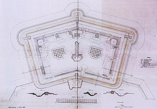
A polygonal fort is a type of fortification originating in France in the late 18th century and fully developed in Germany in the first half of the 19th century. Unlike earlier forts, polygonal forts had no bastions, which had proved to be vulnerable. As part of ring fortresses, polygonal forts were generally arranged in a ring around the place they were intended to protect, so that each fort could support its neighbours. The concept of the polygonal fort proved to be adaptable to improvements in the artillery which might be used against them, and they continued to be built and rebuilt well into the 20th century.

<span class="mw-page-title-main">5.7 cm Maxim-Nordenfelt</span> Fortress gun

The 5.7 cm Maxim-Nordenfelt"Canon de caponnière" was a fortress gun and infantry gun developed during the 1880s in Britain which was sold to Belgium and later produced under license by the Cockerill company. It saw action during World War I in both Belgian and German hands.

<span class="mw-page-title-main">Kurt Rackow</span>

Kurt Rackow was a German military officer and Pour le Mérite recipient who served in the Imperial German Army, Freikorps, and Reichswehr during World War I and the German Revolution of 1918–19. Rackow's most famous action was leading the capture of Fort Vaux during the Battle of Verdun.

<span class="mw-page-title-main">Fort Souville</span>

Fort Souville, briefly called Fort Lemoine, was one of the forts of the Verdun Fortification District, situated in the commune of Fleury-devant-Douaumont. Constructed between 1876 and 1879 at an altitude of 396m, it is a first generation fort. It served as a key battlefield in the 1916 Battle of Verdun during World War I. The fort was armed on its ramparts with 9 cannons and 5 mortars, with 8 pieces of artillery used as flanking fire. A Bussiere turret in attached battery was also present.

<span class="mw-page-title-main">Hans von Guretzky-Cornitz</span> Imperial German Army general (1855–1917)

Hans Karl von Guretzky-Cornitz (1855–1917) was a German army general of the First World War. He was commander of the 9th Reserve Division during the early part of the war. He is noted for an incident during the 1916 Battle of Verdun when he falsely reported capturing Fort Vaux and was awarded the Pour le Mérite.

References

49°13′1″N5°26′18″E / 49.21694°N 5.43833°E / 49.21694; 5.43833