Groix

Last updated • 1 min readFrom Wikipedia, The Free Encyclopedia

Groix
Groe
Aerial view of Groix.jpg
Aerial view of Groix
Blason ville fr Groix (Morbihan).svg
Location of Groix
Groix
France location map-Regions and departements-2016.svg
Red pog.svg
Groix
Bretagne region location map.svg
Red pog.svg
Groix
Coordinates: 47°38′22″N3°27′13″W / 47.6394°N 3.4536°W / 47.6394; -3.4536
Country France
Region Brittany
Department Morbihan
Arrondissement Lorient
Canton Lorient-2
Intercommunality Lorient Agglomération
Government
  Mayor (20202026) Dominique Yvon [1]
Area
1
14.82 km2 (5.72 sq mi)
Population
 (2021) [2]
2,282
  Density150/km2 (400/sq mi)
Time zone UTC+01:00 (CET)
  Summer (DST) UTC+02:00 (CEST)
INSEE/Postal code
56069 /56590
Elevation0–48 m (0–157 ft)
1 French Land Register data, which excludes lakes, ponds, glaciers > 1 km2 (0.386 sq mi or 247 acres) and river estuaries.

Groix (French pronunciation: [ɡʁwa] ; Breton : Enez Groe) is an island and a commune in the Morbihan department of the region of Brittany in north-western France.

Contents

Groix lies a few kilometres off the coast of Lorient. Several ferries a day run from Lorient to Groix.

There are a few small towns on the island. High cliffs are on its north coast and sandy beaches in secluded coves on the south coast. Groix is also home to a wide variety of sea birds. Groix is also famous for hosting the only convex beach in Europe, which also moves following sea currents. During the last 15 years, the beach moved half a kilometer westbound.

The geology of Groix is distinct from that of the nearby continent, and the east and south coasts have been designated a mineral nature reserve since 1982.[ citation needed ] More than 60 minerals can be found on the island, particularly blue glaucophane (observable on the surface), epidote or garnet.[ citation needed ] The island mainly consists of schist.[ citation needed ]

A major naval battle between Britain and France took place off Groix in 1795.

The island is the major setting in the fourth book of The Enzo Files - 'Freeze Frame' - by author Peter May.

Climate

Climate data for Groix (1981–2010 averages)
MonthJanFebMarAprMayJunJulAugSepOctNovDecYear
Record high °C (°F)15.4
(59.7)
16.6
(61.9)
22.8
(73.0)
25.8
(78.4)
29.7
(85.5)
35.6
(96.1)
35.3
(95.5)
35.2
(95.4)
31.0
(87.8)
26.5
(79.7)
19.5
(67.1)
16.0
(60.8)
35.6
(96.1)
Mean daily maximum °C (°F)9.5
(49.1)
9.5
(49.1)
11.5
(52.7)
13.6
(56.5)
16.6
(61.9)
19.2
(66.6)
21.0
(69.8)
21.3
(70.3)
19.8
(67.6)
16.3
(61.3)
12.7
(54.9)
10.2
(50.4)
15.1
(59.2)
Mean daily minimum °C (°F)5.7
(42.3)
5.3
(41.5)
6.8
(44.2)
7.9
(46.2)
10.8
(51.4)
13.3
(55.9)
15.1
(59.2)
15.3
(59.5)
13.8
(56.8)
11.7
(53.1)
8.8
(47.8)
6.4
(43.5)
10.1
(50.2)
Record low °C (°F)−9.4
(15.1)
−8.0
(17.6)
−6.2
(20.8)
−1.0
(30.2)
0.4
(32.7)
5.8
(42.4)
7.8
(46.0)
8.4
(47.1)
7.6
(45.7)
1.8
(35.2)
−2.4
(27.7)
−6.0
(21.2)
−9.4
(15.1)
Average precipitation mm (inches)95.7
(3.77)
70.6
(2.78)
65.0
(2.56)
61.3
(2.41)
59.2
(2.33)
42.2
(1.66)
42.7
(1.68)
39.1
(1.54)
56.4
(2.22)
92.3
(3.63)
91.3
(3.59)
98.9
(3.89)
814.7
(32.07)
Average relative humidity (%)87868582848383838386868884.7
Source 1: Météo France [3]
Source 2: Infoclimat.fr (humidity, 1961–1990) [4]

Population

Historical population
YearPop.±% p.a.
1968 3,161    
1975 2,727−2.09%
1982 2,605−0.65%
1990 2,472−0.65%
1999 2,275−0.92%
2007 2,291+0.09%
2012 2,223−0.60%
2017 2,263+0.36%
Source: INSEE [5]

Inhabitants of Groix are called Groisillons in French.

See also

Related Research Articles

<span class="mw-page-title-main">Charente-Maritime</span> Department of France

Charente-Maritime is a département in the Nouvelle-Aquitaine region on the southwestern coast of France. Named after the river Charente, its prefecture is La Rochelle. As of 2019, it had a population of 651,358 with an area of 6,864 square kilometres.

<span class="mw-page-title-main">Brittany (administrative region)</span> Administrative region of France

Brittany is the westernmost region of Metropolitan France. It covers about four fifths of the territory of the historic province of Brittany. It is one of two regions in Metropolitan France that do not contain any landlocked departments, the other being Corsica.

<span class="mw-page-title-main">Morbihan</span> Department of France

The Morbihan is a department in the administrative region of Brittany, situated in the northwest of France. It is named after the Morbihan, the enclosed sea that is the principal feature of the coastline. It had a population of 759,684 in 2019. It is noted for its Carnac stones, which predate and are more extensive than the Stonehenge monument in Wiltshire, England.

<span class="mw-page-title-main">Lorient</span> Subprefecture and commune in Brittany, France

Lorient is a town (commune) and seaport in the Morbihan department of Brittany in western France.

<span class="mw-page-title-main">Belle Île</span> Island off the coast of Brittany

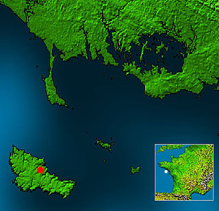
Belle-Île, Belle-Île-en-Mer, or Belle Isle is a French island off the coast of Brittany in the département of Morbihan, and the largest of Brittany's islands. It is 14 kilometres from the Quiberon peninsula.

<span class="mw-page-title-main">Ushant</span> Commune in Brittany, France

Ushant is a French island at the southwestern end of the English Channel which marks the westernmost point of metropolitan France. It belongs to Brittany and in medieval times, Léon. In lower tiers of government, it is a commune in the Finistère department. It is the only place in Brittany, save for Brittany itself, with a separate name in English.

<span class="mw-page-title-main">Houat</span> Island and commune in Brittany, France

Houat is a French island off the south coast of Brittany in the department of Morbihan. It is located, along with two other major islands, in the entrance to the Baie de Quiberon. Its "twin sister" island is Hoëdic.

<span class="mw-page-title-main">Hœdic</span> Island and commune in Brittany, France

Hœdic or Hoëdic is an island off the south coast of Brittany in northwestern France. Its bigger "twin sister" island is Houat.

<span class="mw-page-title-main">Baud, Morbihan</span> Commune in Brittany, France

Baud is a commune in the Morbihan département in Brittany in northwestern France.

<span class="mw-page-title-main">Arrondissement of Lorient</span> Arrondissement in Brittany, France

The arrondissement of Lorient is an arrondissement of France in the Morbihan department in the Brittany region. It has 58 communes. Its population is 312,063 (2016), and its area is 1,461.8 km2 (564.4 sq mi).

<span class="mw-page-title-main">Bangor, Morbihan</span> Commune in Brittany, France

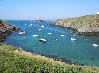
Bangor is a commune in the Morbihan department in the Brittany region of north-western France. It is one of the four communes on the island of Belle-Île.

<span class="mw-page-title-main">Lanester</span> Commune in Brittany, France

Lanester is a commune in the Morbihan department in Brittany, in north-western France.

<span class="mw-page-title-main">Ploemeur</span> Commune in Brittany, France

Ploemeur, sometimes written instead as Plœmeur, is a commune in the Morbihan department in the region of Brittany in north-western France. It is a western suburb of Lorient.

<span class="mw-page-title-main">Sauzon</span> Commune in Brittany, France

Sauzon is a commune on the island of Belle Île in the Morbihan department of the region of Brittany in north-western France. Inhabitants of Sauzon are called Sauzonnais.

<span class="mw-page-title-main">Larmor-Baden</span> Commune in Brittany, France

Larmor-Baden is a commune in the Morbihan department of Brittany in northwestern France. The inhabitants of Larmor-Baden are called in French Larmoriens.

<span class="mw-page-title-main">Locmaria</span> Commune in Brittany, France

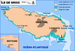
Locmaria is a commune in the Morbihan department in Brittany in north-western France. Locmaria is one of the four communes of Belle Île.

<span class="mw-page-title-main">Le Palais</span> Commune in Brittany, France

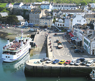
Le Palais is a commune in the Morbihan department of Brittany in northwestern France. It is one of the four communes on the island of Belle Île.

<span class="mw-page-title-main">Plouray</span> Commune in Brittany, France

Plouray is a commune in the Morbihan department of Brittany in north-western France. Inhabitants of Plouray are called in French Plouraysiens.

<span class="mw-page-title-main">Saint Barthélemy</span> Overseas collectivity of France

Saint Barthélemy, officially the Collectivité territoriale de Saint-Barthélemy, also known as St. Barts (English) or St. Barth (French), is an overseas collectivity of France in the Caribbean. The island lies about 30 kilometres (19 mi) southeast of the island of Saint Martin; it is northeast of the Dutch islands of Saba and Sint Eustatius, as well as north of the independent country of Saint Kitts and Nevis.

<span class="mw-page-title-main">Roadstead of Lorient</span> Roadstead or bay in France

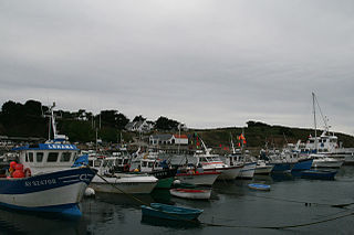
The roadstead of Lorient is a roadstead located to the west of Morbihan in Brittany, France.

References

  1. "Maires du Morbihan" (PDF). Préfecture du Morbihan. 7 July 2020.
  2. "Populations légales 2021" (in French). The National Institute of Statistics and Economic Studies. 28 December 2023.
  3. "Données climatiques de la station de Ile de Groix" (in French). Meteo France. Archived from the original on 7 February 2016. Retrieved 30 December 2015.
  4. "Normes et records 1961-1990: Ile de Groix - Beg Melen (56) - altitude 42m" (in French). Infoclimat. Retrieved 30 December 2015.
  5. Population en historique depuis 1968, INSEE

Bibliography