Séglien

Last updated • 1 min readFrom Wikipedia, The Free Encyclopedia

Séglien
Seglian
Seglien eglise Notre Dame de Lorette.jpg
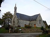
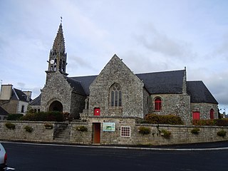
The parish church in Séglien
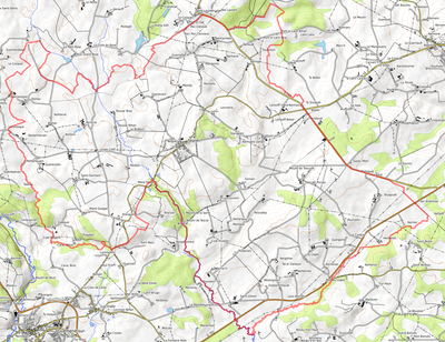
Location of Séglien
Seglien
France location map-Regions and departements-2016.svg
Red pog.svg
Séglien
Bretagne region location map.svg
Red pog.svg
Séglien
Coordinates: 48°06′28″N3°09′30″W / 48.1078°N 3.1583°W / 48.1078; -3.1583
Country France
Region Brittany
Department Morbihan
Arrondissement Pontivy
Canton Gourin
Intercommunality Pontivy Communauté
Government
  Mayor (20202026) Laurent Ganivet [1]
Area
1
38.36 km2 (14.81 sq mi)
Population
 (2021) [2]
638
  Density17/km2 (43/sq mi)
Time zone UTC+01:00 (CET)
  Summer (DST) UTC+02:00 (CEST)
INSEE/Postal code
56242 /56160
Elevation123–248 m (404–814 ft)
1 French Land Register data, which excludes lakes, ponds, glaciers > 1 km2 (0.386 sq mi or 247 acres) and river estuaries.

Séglien (French pronunciation: [seɡlijɛ̃] ; Breton : Seglian) is a commune in the Morbihan department of Brittany in north-western France. [3]

Contents

Demographics

Inhabitants of Séglien are called in French Ségliennais.

Historical population
YearPop.±% p.a.
1793 1,976    
1800 1,953−0.17%
1806 2,004+0.43%
1821 1,876−0.44%
1831 2,054+0.91%
1836 2,122+0.65%
1841 2,071−0.49%
1846 2,230+1.49%
1851 2,175−0.50%
1856 2,010−1.57%
1861 1,957−0.53%
1866 1,980+0.23%
1872 1,867−0.97%
1876 1,973+1.39%
1881 1,951−0.22%
1886 2,014+0.64%
1891 1,978−0.36%
1896 2,005+0.27%
YearPop.±% p.a.
1901 2,077+0.71%
1906 2,103+0.25%
1911 2,090−0.12%
1921 1,981−0.53%
1926 1,862−1.23%
1931 1,861−0.01%
1936 1,791−0.76%
1946 1,760−0.17%
1954 1,413−2.71%
1962 1,299−1.05%
1968 1,115−2.51%
1975 902−2.98%
1982 804−1.63%
1990 724−1.30%
1999 709−0.23%
2009 720+0.15%
2014 696−0.68%
2020 645−1.26%
Source: EHESS [4] and INSEE (1968-2020) [5]

Geography

Séglien is border by Silfiac to the north, by Langoëlan to the west, by Locmalo and Guern to the south and by Malguénac and Cléguérec to the east. Historically, Séglien belongs to Vannetais. The river Sarre, a tributary of the river Blavet, flows through the commune.

Map

Seglien opentopomap.png
Topographic map

History

From the Roman period there remains a section of the Roman road connecting Castennec to Carhaix, passing through Mané-Guégan, Quénécalec and Resterhierven. On this road, not far from Saint-Germain, there is a mutilated cylindrical stone, which could have been a milestone. [6]

See also

Related Research Articles

<span class="mw-page-title-main">Auray</span> Commune in Brittany, France

Auray is a commune in the Morbihan department, administrative region of Brittany, northwestern France.

<span class="mw-page-title-main">Plouay</span> Commune in Brittany, France

Plouay is a commune in the Morbihan department in Brittany in north-western France.

<span class="mw-page-title-main">Pontivy</span> Subprefecture and commune in Brittany, France

Pontivy is a commune in the Morbihan department in Brittany in north-western France. It lies at the confluence of the river Blavet and the Canal de Nantes à Brest. Inhabitants of Pontivy are called Pontivyens in French.

<span class="mw-page-title-main">Locmariaquer</span> Commune in Brittany, France

Locmariaquer is a commune in the Morbihan department in Brittany in north-western France.

<span class="mw-page-title-main">Baud, Morbihan</span> Commune in Brittany, France

Baud is a commune in the Morbihan département in Brittany in northwestern France.

<span class="mw-page-title-main">Guiscriff</span> Commune in Brittany, France

Guiscriff is a commune in the Morbihan department in Brittany in north-western France.

<span class="mw-page-title-main">Le Faouët, Morbihan</span> Commune in Brittany, France

Le Faouët is a commune in the Morbihan department of the region of Brittany in north-western France.

<span class="mw-page-title-main">Cléguérec</span> Commune in Brittany, France

Cléguérec is a commune in the Morbihan department of Brittany in north-western France.

<span class="mw-page-title-main">Gourin</span> Commune in Brittany, France

Gourin is a commune in the Morbihan département of Brittany in north-western France.

<span class="mw-page-title-main">Langoëlan</span> Commune in Brittany, France

Langoëlan is a commune in the Morbihan department of Brittany in north-western France. Inhabitants of Langoëlan are called in French Langoëlanais.

<span class="mw-page-title-main">Lignol, Morbihan</span> Commune in Brittany, France

Lignol is a commune in the Morbihan department of Brittany in north-western France.

<span class="mw-page-title-main">Malguénac</span> Commune in Brittany, France

Malguénac is a commune in the Morbihan department of Brittany in north-western France.

<span class="mw-page-title-main">Mauron</span> Commune in Brittany, France

Mauron is a commune in the Morbihan department and Brittany region of north-western France. It lies close to the borders of both Côtes d'Armor and Ille-et-Vilaine. Mauron's location make it a crossroads on the routes connecting Dinan to Vannes and Quimper to Rennes.

<span class="mw-page-title-main">Ploërdut</span> Commune in Brittany, France

Ploërdut is a commune in the Morbihan department in Brittany in north-western France.

<span class="mw-page-title-main">Priziac</span> Commune in Brittany, France

Priziac is a commune in the Morbihan department of Brittany in north-western France.

<span class="mw-page-title-main">Quistinic</span> Commune in Brittany, France

Quistinic is a commune in the Morbihan department of Brittany in north-western France. Its sister city is the rural village of Loughshinny, which is in County Dublin, Ireland.

<span class="mw-page-title-main">Silfiac</span> Commune in Brittany, France

Silfiac is a commune in the Morbihan department of Brittany in north-western France.

<span class="mw-page-title-main">Le Saint</span> Commune in Brittany, France

Le Saint is a commune in the Morbihan department of Brittany in north-western France.

<span class="mw-page-title-main">Arnay-sous-Vitteaux</span> Commune in Bourgogne-Franche-Comté, France

Arnay-sous-Vitteaux is a commune in the Côte-d'Or department in the Bourgogne-Franche-Comté region of eastern France.

<span class="mw-page-title-main">Saint-Germain-des-Essourts</span> Commune in Normandy, France

Saint-Germain-des-Essourts is a commune in the Seine-Maritime department in the Normandy region in northern France.

References

  1. "Maires du Morbihan" (PDF). Préfecture du Morbihan. 7 July 2020.
  2. "Populations légales 2021" (in French). The National Institute of Statistics and Economic Studies. 28 December 2023.
  3. INSEE commune file
  4. Des villages de Cassini aux communes d'aujourd'hui: Commune data sheet Séglien, EHESS (in French).
  5. Population en historique depuis 1968, INSEE
  6. Histoire des paroisses du Diocèse de Vannes, J-M Le Méné, 1891