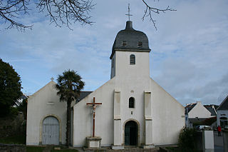
Le Palais

Last updated • 1 min readFrom Wikipedia, The Free Encyclopedia

Le Palais
Porzh-Lae
Ferry de Belle Ile.jpg
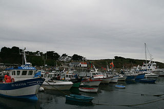
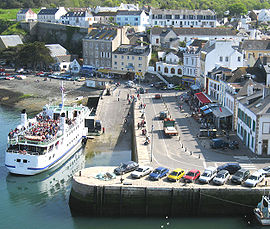
Ferry in the harbour
Flag of Belle-Ile-en-Mer.gif
Blason Le Palais 56.svg
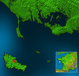
Location of Le Palais
Le Palais
France location map-Regions and departements-2016.svg
Red pog.svg
Le Palais
Bretagne region location map.svg
Red pog.svg
Le Palais
Coordinates: 47°20′50″N3°09′15″W / 47.3472°N 3.1542°W / 47.3472; -3.1542
Country France
Region Brittany
Department Morbihan
Arrondissement Lorient
Canton Quiberon
Intercommunality Belle-Île-en-Mer
Government
  Mayor (20202026) Tibault Grollemund [1]
Area
1
17.43 km2 (6.73 sq mi)
Population
 (2021) [2]
2,552
  Density150/km2 (380/sq mi)
Time zone UTC+01:00 (CET)
  Summer (DST) UTC+02:00 (CEST)
INSEE/Postal code
56152 /56360
Elevation0–58 m (0–190 ft)
1 French Land Register data, which excludes lakes, ponds, glaciers > 1 km2 (0.386 sq mi or 247 acres) and river estuaries.

Le Palais (French pronunciation: [palɛ] ; Breton : Porzh-Lae) is a commune in the Morbihan department of Brittany in northwestern France. [3] It is one of the four communes on the island of Belle Île.

Contents

Geography

Le Palais is one of the four communes of Belle île en Mer. It is the most populated. It houses the administrative center and the main port of the island. The town centre is located 4.5 km (2.8 mi) northeast of Bangor, 5.8 km (3.6 mi) southeast of Sauzon and 8 km (5.0 mi) northwest of Locmaria.

Map

Le palais opentopomap.png
Topographic map.

Population

Inhabitants of Le Palais are called in French Palantins. Le Palais's population peaked in 1872.

Historical population
YearPop.±% p.a.
1793 2,504    
1800 2,307−1.16%
1806 3,107+5.09%
1821 3,258+0.32%
1831 3,584+0.96%
1836 3,646+0.34%
1841 4,544+4.50%
1846 4,551+0.03%
1851 4,972+1.79%
1856 4,845−0.52%
1861 4,896+0.21%
1866 4,852−0.18%
1872 5,456+1.97%
1876 4,885−2.73%
1881 4,801−0.35%
1886 5,126+1.32%
1891 5,113−0.05%
1896 4,931−0.72%
YearPop.±% p.a.
1901 4,964+0.13%
1906 4,949−0.06%
1911 4,950+0.00%
1921 3,185−4.31%
1926 3,206+0.13%
1931 2,802−2.66%
1936 2,786−0.11%
1946 2,208−2.30%
1954 2,724+2.66%
1962 2,728+0.02%
1968 2,661−0.41%
1975 2,634−0.15%
1982 2,389−1.39%
1990 2,435+0.24%
1999 2,457+0.10%
2009 2,545+0.35%
2014 2,580+0.27%
2020 2,536−0.29%
Source: EHESS [4] and INSEE (1968-2020) [5]

See also

Related Research Articles

<span class="mw-page-title-main">Morbihan</span> Department of France

The Morbihan is a department in the administrative region of Brittany, situated in the northwest of France. It is named after the Morbihan, the enclosed sea that is the principal feature of the coastline. It had a population of 759,684 in 2019. It is noted for its Carnac stones, which predate and are more extensive than the Stonehenge monument in Wiltshire, England.

<span class="mw-page-title-main">Belle Île</span> Island off the coast of Brittany

Belle-Île, Belle-Île-en-Mer, or Belle Isle is a French island off the coast of Brittany in the département of Morbihan, and the largest of Brittany's islands. It is 14 kilometres from the Quiberon peninsula.

<span class="mw-page-title-main">Houat</span> Island and commune in Brittany, France

Houat is a French island off the south coast of Brittany in the department of Morbihan. It is located, along with two other major islands, in the entrance to the Baie de Quiberon. Its "twin sister" island is Hoëdic.

<span class="mw-page-title-main">Hœdic</span> Island and commune in Brittany, France

Hœdic or Hoëdic is an island off the south coast of Brittany in northwestern France. Its bigger "twin sister" island is Houat.

<span class="mw-page-title-main">Arrondissement of Lorient</span> Arrondissement in Brittany, France

The arrondissement of Lorient is an arrondissement of France in the Morbihan department in the Brittany region. It has 58 communes. Its population is 312,063 (2016), and its area is 1,461.8 km2 (564.4 sq mi).

<span class="mw-page-title-main">Bangor, Morbihan</span> Commune in Brittany, France

Bangor is a commune in the Morbihan department in the Brittany region of north-western France. It is one of the four communes on the island of Belle-Île.

<span class="mw-page-title-main">Île-aux-Moines</span> Commune in Brittany, France

Île-aux-Moines is a commune in the Morbihan department in the region of Brittany in northwestern France.

<span class="mw-page-title-main">Sauzon</span> Commune in Brittany, France

Sauzon is a commune on the island of Belle Île in the Morbihan department of the region of Brittany in north-western France. Inhabitants of Sauzon are called Sauzonnais.

<span class="mw-page-title-main">Le Faouët, Morbihan</span> Commune in Brittany, France

Le Faouët is a commune in the Morbihan department of the region of Brittany in north-western France.

<span class="mw-page-title-main">Baden, Morbihan</span> Commune in Brittany, France

Baden is a commune in the Morbihan département in Brittany in northwestern France.

<span class="mw-page-title-main">Le Croisty</span> Commune in Brittany, France

Le Croisty is a commune in the Morbihan department of Brittany in north-western France.

<span class="mw-page-title-main">Locmaria</span> Commune in Brittany, France

Locmaria is a commune in the Morbihan department in Brittany in north-western France. Locmaria is one of the four communes of Belle Île.

<span class="mw-page-title-main">Malguénac</span> Commune in Brittany, France

Malguénac is a commune in the Morbihan department of Brittany in north-western France.

<span class="mw-page-title-main">Pénestin</span> Commune in Brittany, France

Pénestin is a commune in the Morbihan department of Brittany in north-western France.

<span class="mw-page-title-main">Pleugriffet</span> Commune in Brittany, France

Pleugriffet is a commune in the Morbihan department of Brittany in north-western France. Inhabitants of Pleugriffet are called in French Pleugriffetois.

<span class="mw-page-title-main">Ploërdut</span> Commune in Brittany, France

Ploërdut is a commune in the Morbihan department in Brittany in north-western France.

<span class="mw-page-title-main">Plouharnel</span> Commune in Brittany, France

Plouharnel is a commune in the Morbihan department of Brittany in north-western France.

<span class="mw-page-title-main">Priziac</span> Commune in Brittany, France

Priziac is a commune in the Morbihan department of Brittany in north-western France.

<span class="mw-page-title-main">Le Saint</span> Commune in Brittany, France

Le Saint is a commune in the Morbihan department of Brittany in north-western France.

<span class="mw-page-title-main">Sainte-Brigitte</span> Commune in Brittany, France

Sainte-Brigitte is a commune in the Morbihan department of Brittany in north-western France.

References

  1. "Maires du Morbihan" (PDF). Préfecture du Morbihan. 7 July 2020.
  2. "Populations légales 2021" (in French). The National Institute of Statistics and Economic Studies. 28 December 2023.
  3. INSEE commune file
  4. Des villages de Cassini aux communes d'aujourd'hui: Commune data sheet Le Palais, EHESS (in French).
  5. Population en historique depuis 1968, INSEE