The Fort de Vancia is a former military installation built between 1872 and 1878 in the municipalities of Sathonay-Village and Rillieux-la-Pape, north of Lyon. It is part of the second belt Lyon and more generally the system Sere de Rivieres. This belt of forts included the forts of Bron, Vancia itself, Feyzin and Mont Verdun.
This pentagonal fort covers about 18 hectares. Located on the plateau and peak Vancia on Dombes to 332 meters, it is disposed between the height of Mont Verdun and Fort Meyzieu. It has been built primarily for the purpose of resisting German and Italian attack from Bourg-en-Bresse, but also in order to confine a potential revolt of the city of Lyon.
The fort consists of seven batteries of 50 guns and covered by three batteries: Sermenaz, Neyron and Sathonay.[1]
Its organization is very similar plans of the forts of Bron and Feyzin, it is not constructed of concrete but in stone,[2] surrounded by a dry ditch along a kilometer in a building concrete will be added to the barracks of the rider in 1895 . The fort was built on the ground and covered by a result of soil from outside.
The fort had a capacity of 800 soldiers divided into two two-story barracks and is 16,000 m², with fifty pieces, two coal-fired ovens, shops and arsenals, two stables, four kitchens, a bakery, four wells, a water tank, a laundry, an infirmary, a forge, and fifty guns. It cost at the time of building 3 million gold francs.
The barracks are composed, on the ground floor of a barn or a shop, with the garrison of the rooms upstairs. Each room has an area of 120 square meters, and housed 25 men arranged in two bunk beds and an officer in a single bed. Meals were served in your room, the bread was suspended in each to protect from rats. Grooves within each window can barricade in case of danger. The path along the barracks is called the street walls and was crossed by a rail allowing, through horse-drawn wagons, to supply the guns quickly.
Two magazines of 70t and 68T provide ammunition to eleven shooting platforms which are placed at the top of the structure on the ridge of high fire and bunkers indirect fire mortar type. Because of the ever-present risk of explosion of the powder by spark, access and layout of magazines included some points:
Skylights can move inside;
movements in the magazine were made in wooden shoes;
bins allow sand to absorb moisture.
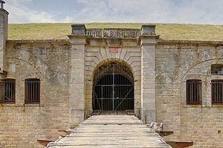
Access to the fort was controlled by a caponier placed on a ravelin built into the rock in front of the pit itself crossed by a crane on rollers. A thick wooden door studded prevents access of the caponier entrance. An iron gate will be added in 1906 before the bridge.
The fort served during the First World War to the French troops, a huge time sink collective is still visible today.
Before 1939 and after World War II, it served as a logistics centre consolidation for reservists and the volunteers, as well as deposit. In 1942, when the fort was still in the free zone. It was used for testing rocket EA-41 by Colonel Jean-Jacques Barre.[1][3]
The fort served as a prison for Germans towards the end of World War II, including opponents of the regime of Franco as well as Habib Bourguiba, former president of Tunisia.
It remained the property of the army until 1999.[citation needed]
Today
Unoccupied for a long time, the fort is now occupied by dense vegetation.
The fort of Vancia currently depend on a single-purpose municipal association, owned by the municipalities of Sathonay-Village and Rillieux-la-Pape . The fort served as occasional training fields for the police, emergency services. The shooting center has always remained property of the Department of Defense. The fort is regularly open for Heritage Days.
The fort was occupied illegally from 4 February 2011 at 18 May 2011 by a group called The fallow Vancia, strong collective self (CFA), the police carried out the evictions and deposited concrete blocks outside the gates and access.[4][5][6]
Panoramic view from the front gate from left to right: Ravelin, a bunker, grid, bridge, caponier gate, all surrounded by a moat.
Bron is a commune in the Metropolis of Lyon in Auvergne-Rhône-Alpes region in eastern France.
Shornemead Fort is a now-disused artillery fort that was built in the 1860s to guard the entrance to the Thames from seaborne attack. Constructed during a period of tension with France, it stands on the south bank of the river at a point where the Thames curves sharply north and west, giving the fort long views up and downriver in both directions. It was the third fort constructed on the site since the 18th century, but its location on marshy ground led to major problems with subsidence. The fort was equipped for a time with a variety of large-calibre artillery guns which were intended to support two other nearby Thamesside forts. However, the extent of the subsidence meant that it became unsafe for the guns to be fired and the fort was disarmed by the early 20th century.
The arrondissement of Lyon is an arrondissement of France in the Auvergne-Rhône-Alpes region. It has 135 communes. Its population is 1,585,411 (2016), and its area is 1,534.6 km2 (592.5 sq mi).
The A46 autoroute is a 47.6-kilometre-long (29.6 mi) highway in central France. It connects the town of Givors to Anse and eastern Lyon. It was completed in 1992.
Ouvrage Barbonnet is a work of the Maginot Line's Alpine extension, the Alpine Line, also called the Little Maginot Line. The ouvrage consists of one entry block and one infantry block facing Italy. The ouvrage was built somewhat behind the main line of fortifications on the old Fort Suchet, which was already armed with two obsolete Mougin 155mm gun turrets.
The Séré de Rivières system was named after Raymond Adolphe Séré de Rivières, its originator. The system was an ensemble of fortifications built from 1874 along the frontiers and coasts of France. The fortresses were obsolescent by 1914 but were still used during the First World War.
Fort de Sucy was built following the Franco-Prussian War to defend Paris. Located to the southeast of Paris in Sucy-en-Brie, the fort was part of an outer ring of eighteen major fortifications built in response to improvements in the range and effectiveness of artillery since the construction of the Thiers fortifications of the 1840s. It was built in accordance with improved principles of fortification developed for the Séré de Rivières system.
The Fort de Liouville, also known as Fort Stengel, located between the communes of Saint-Agnant-sous-les-Côtes and Saint-Julien-sous-les-Côtes, near the town of Commercy in the Meuse departement of France, is one of the forts built at the end of the 19th century to defend the valley of the Meuse. The fort was located on what was then the French frontier facing the German-occupied province of Lorraine. The Fort de Liouville was located between the Fort de Gironville and the Camp des Romains.
Fort du Mont Bart is located to the south of Montbéliard, France. It was built between November 1874 and July 1877 as part of the Séré de Rivières system of fortifications. The fort overlooks the valleys of the Doubs and the Allan at an elevation of 497 metres (1,631 ft), standing to the south and rear of the fortified region of Belfort and in control of the road to Besançon. The fort was intended to augment the Belfort fortifications and to prevent an enemy from bypassing them. The most striking feature of the Fort du Mont Bart is its "interior street", originally constructed in the open air as a sunken court, then covered before World War I with reinforced concrete.
The Fort de Bois l'Abbé, or Fort Poniatowski, is part of the fortifications of Épinal, France. It was built near the village of Uxegney between 1883 and 1885. It is an example of a Séré de Rivières system fortification. It escaped significant alteration in the years prior to World War I and is maintained as a museum.
The Fort des Adelphes, or Fort Richepance, is part of the fortifications of Épinal. It was built near the village of Deyvillers between 1883 and 1885, and was modernized beginning in 1907. It is an example of a Séré de Rivières system fortification. During World War II the fort surrendered to German forces and was then used by the Germans to fire on neighboring forts Longchamp and Dogneville. The fort is now occupied by an activity of the French Air Force associated with Base aerienne 133 Nancy-Ochey and is not accessible to the public.
The Fort du Bruissin is a fort in Francheville, France, near the city of Lyon. Built between 1878 and 1881, the fort is part of the Séré de Rivières system of fortifications built in the late 19th century. It has been rehabilitated as a contemporary artists' community. The Fort en Jazz festival is held there each year.
The Fort de Bourlémont, or Fort Choiseul, was built between 1878 and 1881. The fort was built as part of the Séré de Rivières system of fortifications, which were conceived in response to the increasing power and range of artillery. The Fort de Bourlémont was part of the defenses of the Charmes Gap, in the town of Mont-lès-Neufchâteau, 3 kilometres (1.9 mi) west of Neufchâteau.
Yuval Pick, born in 1970 in Israel, is a choreographer and the director of the National Choreographic Center of Rillieux-la-Pape (France).
Metropolitan Lyon, also known as Grand Lyon, is a French territorial collectivity located in the east-central region of Auvergne-Rhône-Alpes. Encompassing the city of Lyon and most of its suburbs, it has jurisdiction as both a department and a métropole, taking the territory out of the purview of the department of Rhône.
The Fort de Bron is a fortification built between 1875 and 1877, located in the commune of Bron. It is part of the second belt of fortifications around Lyon, which also includes Fort de Vancia, Fort de Feyzin and Fort du Mont Verdun.
The Fort Feyzin is a fort built between 1875 and 1877 in Feyzin. It is one of the forts of the second belt of forts around Lyon and more generally the Séré de Rivières fort system. This belt of forts included the forts of Bron, Vancia, Feyzin and Mont Verdun. It currently houses a riding stable managed by the UCPA on behalf of the city of Feyzin.
Fort Mont Verdun is the biggest highlight of the second belt of Forts around Lyon and is the only one considered to be a mountain fort. It rests at 630 meters altitude, dominating Lyon, Limonest, the lower Azergues valley and the Saône valley. It was covered by a low battery and four other associated batteries: Mont Thou, Les Carrières, Narcel and La Freta. It is now occupied by the Airbase 942 Lyon-Mont Verdun.
The ceintures de Lyon were a series of fortifications built between 1830 and 1890 around the city of Lyon, France to protect the city from foreign invasion.
References
1 2 Dallemagne, François (2006), Éditions Lyonnaises d'Art et d'Histoire (ed.), Les défenses de Lyon: enceintes et fortifications (in French), Georges Fessy(photographer), Lyon, p.197, ISBN2-84147-177-2
This page is based on this Wikipedia article Text is available under the CC BY-SA 4.0 license; additional terms may apply. Images, videos and audio are available under their respective licenses.