Mounsey Castle

Last updated

Mounsey Castle
Mounsey Castle Somerset Map.jpg
Plan of Mounsey Castle
Location Dulverton, Somerset, England
Coordinates 51°03′16″N3°35′36″W / 51.05444°N 3.59333°W / 51.05444; -3.59333
Area1.75 hectares (4.3 acres)
Built Iron Age
Official nameMounsey Castle and associated outwork 100m to the north
Reference no.35638 [1]
Somerset UK location map.svg
Red pog.svg
Location of Mounsey Castle in Somerset

Mounsey Castle is an Iron Age irregular triangular earthwork of 1.75 hectares (4.3 acres) north west of Dulverton, Somerset, England. It has been scheduled as an ancient monument. [1] [2] It has been added to the Heritage at Risk Register. [3] [4]

Contents

It is named after the Monceaux family, who were the local lords of the manor in the Middle Ages. [2] [5]

The earthwork is surrounded by the remains of coursed stone rampart which is between 1.5 metres (4 ft 11 in) and 2 metres (6 ft 7 in) high, [2] with an entrance to the west. [6] [7] For most of its circumference it is univallate however where the slope is not so steep on the eastern and southern sides there is a second rampart. [8] The remains of a stone building can be seen within the hillfort, which is likely to have been a charcoal burners hut. [2]

It overlooks the River Barle. [2]

Background

Hill forts developed in the Late Bronze and Early Iron Age, roughly the start of the first millennium BC. [9] The reason for their emergence in Britain, and their purpose, has been a subject of debate. It has been argued that they could have been military sites constructed in response to invasion from continental Europe, sites built by invaders, or a military reaction to social tensions caused by an increasing population and consequent pressure on agriculture. The dominant view since the 1960s has been that the increasing use of iron led to social changes in Britain. Deposits of iron ore were located in different places to the tin and copper ore necessary to make bronze, and as a result trading patterns shifted and the old elites lost their economic and social status. Power passed into the hands of a new group of people. [10] Archaeologist Barry Cunliffe believes that population increase still played a role and has stated "[the forts] provided defensive possibilities for the community at those times when the stress [of an increasing population] burst out into open warfare. But I wouldn't see them as having been built because there was a state of war. They would be functional as defensive strongholds when there were tensions and undoubtedly some of them were attacked and destroyed, but this was not the only, or even the most significant, factor in their construction". [11]

See also

Related Research Articles

<span class="mw-page-title-main">Cadbury Castle, Somerset</span> Hillfort in Somerset, England

Cadbury Castle is a Bronze and Iron Age hillfort in the civil parish of South Cadbury in the English county of Somerset. It is a scheduled monument and has been associated with King Arthur's legendary court at Camelot.

<span class="mw-page-title-main">Maesbury Castle</span> Iron Age hillfort in Somerset, England

Maesbury Castle is an Iron Age hill fort within the parish of Croscombe on the Mendip Hills, just north of Shepton Mallet, Somerset, England. It has been listed as a Scheduled Ancient Monument.

<span class="mw-page-title-main">Plainsfield Camp</span> Iron Age earthwork in Somerset, England

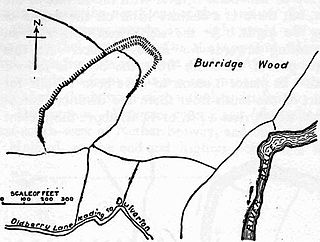
Plainsfield Camp is a possible Iron Age earthwork on the Quantock Hills near Aisholt in Somerset, England.

<span class="mw-page-title-main">Norton Camp</span> Bronze Age hillfort in Somerset, England

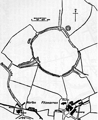
Norton Camp is a Bronze Age hill fort at Norton Fitzwarren near Taunton in Somerset, England.

<span class="mw-page-title-main">Bat's Castle</span> Iron Age hillfort in Somerset, England

Bats Castle is an Iron Age hillfort at the top of a 213 metres (699 ft) high hill in the parish of Carhampton south south west of Dunster in Somerset, England.

<span class="mw-page-title-main">Black Ball Camp</span> Iron Age hillfort in Somerset, England

Black Ball Camp is an Iron Age hillfort South West of Dunster, Somerset, England on the northern summit of Gallox Hill. It is a Scheduled Monument.

Blacker's Hill is an Iron Age hill fort at Chilcompton, 4.5 kilometres (3 mi) south west of Radstock, Somerset, England. It has been designated as a Scheduled Ancient Monument.

<span class="mw-page-title-main">Bury Castle, Selworthy</span> Iron Age hillfort in Somerset, England

Bury Castle is an Iron Age hillfort near Selworthy, Somerset, England. It has been designated as a scheduled monument.

<span class="mw-page-title-main">Clatworthy Camp</span> Iron Age hillfort in Somerset, England

Clatworthy Camp is an Iron Age hill fort 3 miles (4.8 km) North West of Wiveliscombe, Somerset, England. It has been scheduled as an Ancient Monument. Due to the vulnerability to scrub and tree growth it has been added to the Heritage at Risk Register.

<span class="mw-page-title-main">Cow Castle</span> Iron Age hillfort in Somerset, England

Cow Castle is an Iron Age hillfort 5.75 kilometres (4 mi) West South West of Exford, Somerset, England within the Exmoor National Park. It is a Scheduled Monument. It has been added to the heritage at Risk register because of the risk from bracken.

<span class="mw-page-title-main">Kenwalch's Castle</span> Historic site in Somerset, England

Kenwalch's Castle is probably an Iron Age hill fort that may have been converted into a Roman fortress, near Penselwood, Somerset, England, 6.6 kilometres (4 mi) east south east of Bruton at grid reference ST747335. It is a Scheduled Ancient Monument. It is believed to be named after Cenwalh of Wessex.

<span class="mw-page-title-main">Sweetworthy</span> Site of two Iron Age hillforts in Somerset, England

Sweetworthy is the site of two Iron Age hill forts or enclosures at Luccombe, 4 kilometres (2 mi) south of Porlock, Somerset, England. They are on the north-facing slope of Dunkery Hill. One has a single rampart and external ditch, enclosing 0.25 hectares. The rampart is still visible and the ditch on the east side is used as a trackway. There was a defended settlement above the main site.

Westbury Camp is a univallate Iron Age hill fort in the Mendip Hills in Somerset, England. The hill fort is situated in the parish of Rodney Stoke, approximately 1 mile (1.6 km) north-east of the village of Draycott and 1.5 miles (2.4 km) north-west of Westbury-sub-Mendip. The camp is largely situated in a hill slope. The north east defences have largely been destroyed by small quarries over the years. The narrow top of the hill bank suggests that it may have been surmounted by a dry stone wall. Along part of the east side of the camp there are traces of a berm between the bank and the outer ditch and at the western angle shallow quarry pits occur internally and externally set back from the 'rampart'.

<span class="mw-page-title-main">Roddenbury Hillfort</span> Iron Age hillfort in Somerset, England

Roddenbury Hillfort is a univallate Iron Age hillfort in the parish of Selwood, Somerset, England. It is a Scheduled Monument and it was on the Heritage at Risk Register in 2011. In 2012 it was announced that it was to undergo major repairs following damage by off road biking. It is close to the later Hales Castle.

<span class="mw-page-title-main">Oldberry Castle</span> Iron Age hillfort in Somerset, England

Oldberry Castle is an Iron Age hill fort north west of Dulverton, Somerset, England. It lies approximately 0.5 miles (0.80 km) north-west from Dulverton, close to the Devon border. It has been designated as a Scheduled Ancient Monument.

Brewer's Castle is a defended Iron Age settlement in the West Somerset district of Somerset, England. The hill fort is situated approximately 2 miles (3.2 km) west from the town of Dulverton.

Berry Castle is an early Roman hillslope enclosure in the West Somerset district of Somerset, England. The hill fort is situated approximately 3.2 miles (5.1 km) west from the village of Luccombe. A series of earthworks survive in Berry Castle; it dates from the late Iron Age or early Romano British period. It has been protected as a scheduled monument.

<span class="mw-page-title-main">Long Wood Enclosure</span> Historic site in Somerset, England

Long Wood Enclosure is an enclosure which may have been a univallate Iron Age hill fort, in the West Somerset district of Somerset, England. The hill fort is situated approximately 3.5 kilometres (2.2 mi) southwest of the village of Dunster. It has been scheduled as an ancient monument.

<span class="mw-page-title-main">Rodhuish Common</span> Iron Age hillfort in Somerset, England

Rodhuish Common is a univallate Iron Age hill fort in the West Somerset district of Somerset, England. There is a small oval enclosure which is thought to be of Iron Age date.

References

  1. 1 2 "Mounsey Castle". National Monuments Record. English Heritage . Retrieved 24 March 2011.
  2. 1 2 3 4 5 "Mounsey Castle and an associated outwork 100m to the north". National Heritage List for England. Historic England. Archived from the original on 2 May 2014. Retrieved 26 September 2016.
  3. "Mounsey Castle, Dulverton, West Somerset - Exmoor (NP)". Heritage at Risk. English Heritage. Archived from the original on 22 October 2013. Retrieved 20 October 2013.
  4. "Mounsey Castle, Dulverton, West Somerset - Exmoor (NP)". Heritage at Risk. Historic England. Retrieved 26 September 2016.
  5. Riley, Hazel; Wilson-North, Robert (2001). The Field Archaeology of Exmoor (PDF). English Heritage. p. 63. ISBN   1873592582.
  6. "Mounsey Castle". Exmoor National Park Historic Environment Record. English Heritage . Retrieved 16 January 2011.
  7. "Mounsey Castle and associated outwork 100m to the north". Historic Environment Record. Somerset County Council . Retrieved 28 February 2011.
  8. Moore, John H. "Iron Age". John H Moore. Retrieved 26 September 2016.
  9. Payne, Andrew; Corney, Mark; Cunliffe, Barry (2007), The Wessex Hillforts Project: Extensive Survey of Hillfort Interiors in Central Southern England, English Heritage, p. 1, ISBN   978-1-873592-85-4
  10. Sharples, Niall M (1991), English Heritage Book of Maiden Castle, London: B. T. Batsford, pp. 71–72, ISBN   0-7134-6083-0
  11. Time Team: Swords, skulls and strongholds, Channel 4, 19 May 2008, retrieved 16 September 2009