Monolith–monocline distinction
Mount Augustus is widely claimed in tourist promotional and information literature as the "world's largest monolith", [3] [4] but the claim does not originate from the geological literature, nor is it substantiated by any other scholarly research. [5]
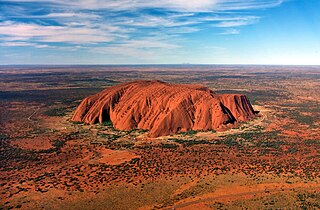
Mt. Augustus is more than twice the size of Uluru. [6] Unlike Uluru, which is a monolith and, in general, devoid of plant growth, Mt. Augustus is a monocline (an asymmetrical anticline).
According to the Geological Survey of Western Australia, Mount Augustus is an asymmetrical anticline (rock layers that have been folded into an arch-like structure) which is steeper on its north-eastern side than the south-west.
The rocks consist of sand and gravel that were deposited by an ancient, south-easterly flowing river system that drained the region about 1,600 million years ago. This river system flowed over a faulted and eroded surface of 1,800–1,620 million-year-old granitic and metamorphic rocks. The river deposits consolidated to form sandstone and conglomerate, and were then buried beneath younger marine sediments, which were laid down when shallow seas covered the region between 1,600–1,070 million years ago.
The rocks were buckled into their present-day structure about 900 million years ago when movement along faults in the underlying granitic and metamorphic rocks caused localised, strong, north-east directed compression. The marine sedimentary rocks that overlay the sandstone and conglomerate have since been eroded from Mount Augustus, but now form the hills around Cobra and Mount Augustus homesteads. Erosion has also removed sandstone and conglomerate from the north-western end of Mount Augustus to expose the underlying granitic rocks at The Pound. [7]

Bald Rock National Park is a national park in northern New South Wales, Australia, just north of Tenterfield on the Queensland border. The border passes over the rock on the Western side. On the other side of the border national park continues as the Girraween National Park.

Mount Augustus National Park is located 852 km north of Perth, 490 km by road east of Carnarvon and 390 km northwest of Meekatharra, in the Gascoyne region of Western Australia. Mount Augustus itself, the feature around which the national park is based, is known as Burringurrah to the local Wadjari Aboriginal people.

Uluru, also known as Ayers Rock and officially gazetted as Uluru / Ayers Rock, is a large sandstone rock formation in the southern part of the Northern Territory in central Australia. It lies 335 km (208 mi) south west of the nearest large town, Alice Springs.
A monolith is a geological feature consisting of a single massive stone or rock, such as some mountains, or a single large piece of rock placed as, or within, a monument or building. Erosion usually exposes the geological formations, which are often made of very hard and solid igneous or metamorphic rock.
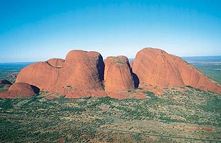
Kata Tjuṯa,, also known as the Olgas, is a group of large, domed rock formations or bornhardts located about 360 km (220 mi) southwest of Alice Springs, in the southern part of the Northern Territory, central Australia. Uluru, also known as Ayers Rock, located 25 km (16 mi) to the east, and Kata Tjuṯa form the two major landmarks within the Uluru-Kata Tjuṯa National Park. The park is considered sacred to the Aboriginal people of Australia.

Conglomerate is a clastic sedimentary rock that is composed of a substantial fraction of rounded to subangular gravel-size clasts. A conglomerate typically contain a matrix of finer grained sediments, such as sand, silt, or clay, which fills the interstices between the clasts. The clasts and matrix are typically cemented by calcium carbonate, iron oxide, silica, or hardened clay.

Arkose is a detrital sedimentary rock, specifically a type of sandstone containing at least 25% feldspar. Arkosic sand is sand that is similarly rich in feldspar, and thus the potential precursor of arkose.

The Narryer Gneiss Terrane is a geological complex in Western Australia that is composed of a tectonically interleaved and polydeformed mixture of granite, mafic intrusions and metasedimentary rocks in excess of 3.3 billion years old, with the majority of the Narryer Gneiss Terrane in excess of 3.6 billion years old. The rocks have experienced multiple metamorphic events at amphibolite or granulite conditions, resulting in often complete destruction of original igneous or sedimentary (protolith) textures. Importantly, it contains the oldest known samples of the Earth's crust: samples of zircon from the Jack Hills portion of the Narryer Gneiss have been radiometrically dated at 4.4 billion years old, although the majority of zircon crystals are about 3.6-3.8 billion years old.

The geology of Tasmania is complex, with the world's biggest exposure of diabase, or dolerite. The rock record contains representatives of each period of the Neoproterozoic, Paleozoic, Mesozoic and Cainozoic eras. It is one of the few southern hemisphere areas that were glaciated during the Pleistocene with glacial landforms in the higher parts. The west coast region hosts significant mineralisation and numerous active and historic mines.

Pine Mountain is a gigantic monolith, said to be 1.5 times bigger than Uluru, situated in the Burrowa-Pine Mountain National Park in Australia.
Geologically the Australian state of New South Wales consists of seven main regions: Lachlan Fold Belt, the Hunter-Bowen Orogeny or New England Orogen (NEO), the Delamerian Orogeny, the Clarence Moreton Basin, the Great Artesian Basin, the Sydney Basin, and the Murray Basin.
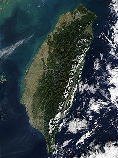
The island of Taiwan is active geologically, formed on a complex convergent boundary between the Yangtze Subplate of the Eurasian Plate to the west and north, the Okinawa Plate on the north-east, the Philippine Plate on the east and south, and the Sunda Plate to the southwest. Subduction changes direction at Taiwan. The upper part of the crust on the island is primarily made up of a series of terranes, mostly old island arcs which have been forced together by the collision of the forerunners of the Eurasian Plate and the Philippine Sea Plate, which is moving to the northwest. These have been further uplifted as a result of the detachment of a portion of the Eurasian Plate as it was subducted beneath remnants of the Philippine Sea Plate, a process which left the crust under Taiwan more buoyant.
Mount Wudinna is located near the locality of Wudinna, South Australia.
The geology of Liberia is largely extremely ancient rock formed between 3.5 billion and 541 million years ago in the Archean and the Neoproterozoic, with some rocks from the past 145 million years near the coast. The country has rich iron resources as well as some diamonds, gold and other minerals in ancient sediment formations weathered to higher concentrations by tropical rainfall.
The geology of Cameroon is almost universally Precambrian metamorphic and igneous basement rock, formed in the Archean as part of the Congo Craton and the Central African Mobile Zone and covered in laterite, recent sediments and soils. Some parts of the country have sequences of sedimentary rocks from the Paleozoic, Mesozoic and Cenozoic as well as volcanic rock produced by the 1600 kilometer Cameroon Volcanic Line, which includes the still-active Mount Cameroon. The country is notable for gold, diamonds and some onshore and offshore oil and gas.

The geological history of Zambia begins in the Proterozoic eon of the Precambrian. The igneous and metamorphic basement rocks tend to be highly metamorphosed and may have formed earlier in the Archean, but heat and pressure has destroyed evidence of earlier conditions. Major sedimentary and metamorphic groups formed in the mid-Proterozoic, followed by a series of glaciations in the Neoproterozoic and much of the Paleozoic which deposited glacial conglomerate as well as other sediments to form the Katanga Supergroup and rift-related Karoo Supergroup. Basalt eruptions blanketed the Karoo Supergroup in the Mesozoic and Zambia shifted to coal and sandstone formation. Geologically recent windblown sands from the Kalahari Desert and alluvial deposits near rivers play an important role in the modern surficial geology of Zambia. The country has extensive natural resources, particularly copper, but also cobalt, emeralds, other gemstones, uranium and coal.
The geology of Nigeria formed beginning in the Archean and Proterozoic eons of the Precambrian. The country forms the Nigerian Province and more than half of its surface is igneous and metamorphic crystalline basement rock from the Precambrian. Between 2.9 billion and 500 million years ago, Nigeria was affected by three major orogeny mountain-building events and related igneous intrusions. Following the Pan-African orogeny, in the Cambrian at the time that multi-cellular life proliferated, Nigeria began to experience regional sedimentation and witnessed new igneous intrusions. By the Cretaceous period of the late Mesozoic, massive sedimentation was underway in different basins, due to a large marine transgression. By the Eocene, in the Cenozoic, the region returned to terrestrial conditions.
The geology of Montana includes thick sequences of Paleozoic, Mesozoic and Cenozoic sedimentary rocks overlying ancient Archean and Proterozoic crystalline basement rock. Eastern Montana has considerable oil and gas resources, while the uplifted Rocky Mountains in the west, which resulted from the Laramide orogeny and other tectonic events have locations with metal ore.
The geology of Israel includes igneous and metamorphic crystalline basement rocks from the Precambrian overlain by a lengthy sequence of sedimentary rocks extending up to the Pleistocene and overlain with alluvium, sand dunes and playa deposits.
