Gill Pinnacle

Last updated

Gill Pinnacle
Australia relief map.jpg
Red triangle with thick white border.svg
Gill Pinnacle
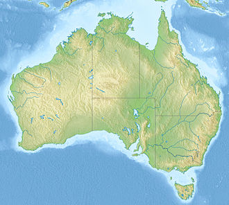
Location of Gill Pinnacle in central Australia
Highest point
Elevation 801 m (2,628 ft)
Coordinates 24°53′29″S128°46′31″E / 24.89139°S 128.77528°E / -24.89139; 128.77528
Geography
Location Western Australia
Parent range Petermann Ranges
Geology
Mountain type inselberg

Gill Pinnacle (or Gill's Pinnacle) is an inselberg located in the far east of Western Australia, on the Ngaanyatjarra Lands. It's part of the Petermann Ranges. It consists of a dome-shaped hill, surrounded by dense mulga; its top is bare rock. The hill has been useful as a landmark, because it marks the location of one of the area's most reliable freshwater rockholes, Gordon's Springs. This is located a few hundred metres to the north of the rock. [1] [2]

The area is called Kutjuṉṯari (also spelled Kudjuṉṯari or Kutjurntari) in Pitjantjatjara and Ngaanyatjarra.

The first European people to visit the area were the explorers Ernest Giles and W. H. Tietkens, in 1874. They saw the rock from Weld Pass, which is further to the west. Giles named the rock after his brother-in-law, and the waterhole, Gordon's Springs, after his nephew. [3] The closest town to Gill's Pinnacle is Kaltukatjara, which is about 31 kilometres (19 mi) to the east in the Northern Territory.
See also

Related Research Articles

Watarrka National Park is a protected area in the Northern Territory of Australia, which contains the popular Kings Canyon (Watarrka).

<span class="mw-page-title-main">Ernest Giles</span> Australian explorer

William Ernest Powell Giles, best known as Ernest Giles, was an Australian explorer who led five major expeditions to parts of South Australia and Western Australia.

<span class="mw-page-title-main">Kata Tjuta</span> Domed rock formations in the Northern Territory

Kata Tjuṯa, also known as The Olgas and officially gazetted as Kata Tjuta / Mount Olga, is a group of large, domed rock formations or bornhardts located about 360 km (220 mi) southwest of Alice Springs, in the southern part of the Northern Territory, central Australia. Uluṟu / Ayers Rock, located 25 km (16 mi) to the east, and Kata Tjuṯa / The Olgas form the two major landmarks within the Uluṟu-Kata Tjuṯa National Park. The park is considered sacred to the local Aboriginal community.

<span class="mw-page-title-main">Gibson Desert</span> Desert in Western Australia

The Gibson Desert is a large desert in Western Australia, largely in an almost pristine state. It is about 155,000 square kilometres (60,000 sq mi) in size, making it the fifth largest desert in Australia, after the Great Victoria, Great Sandy, Tanami and Simpson deserts. The Gibson Desert is both an interim Australian bioregion and desert ecoregion.

<span class="mw-page-title-main">Pitjantjatjara</span> Aboriginal people of Central Australia

The Pitjantjatjara are an Aboriginal people of the Central Australian desert near Uluru. They are closely related to the Yankunytjatjara and Ngaanyatjarra and their languages are, to a large extent, mutually intelligible.

Warburton or Warburton Ranges is an Aboriginal Australian community in Western Australia, just to the south of the Gibson Desert and located on the Great Central Road and Gunbarrel Highway. At the 2016 census, Warburton had a population of 576.

<span class="mw-page-title-main">Lough Gill</span> Lake in County Sligo, Ireland

Lough Gill is a freshwater lough (lake) mainly situated in County Sligo, but partly in County Leitrim, in Ireland. Lough Gill provides the setting for William Butler Yeats' poem "The Lake Isle of Innisfree".

<span class="mw-page-title-main">Shire of Ngaanyatjarraku</span> Local government area in Western Australia

The Shire of Ngaanyatjarraku is a remote local government area in Western Australia near the Northern Territory/South Australian border. It is 1,542 km (958 mi) from Perth.

<span class="mw-page-title-main">Calingiri, Western Australia</span> Town in Western Australia

Calingiri is a town located north-east of Perth, near New Norcia in Western Australia. It is in the Shire of Victoria Plains.

<span class="mw-page-title-main">Kings Canyon (Northern Territory)</span> Canyon in Northern Territory, Australia

Kings Canyon, also known as Watarrka, is a canyon in the Northern Territory of Australia located at the western end of the George Gill Range about 321 kilometres (199 mi) southwest of Alice Springs and about 1,316 kilometres (818 mi) south of Darwin, within the Watarrka National Park.

<span class="mw-page-title-main">Deserts of Australia</span> Deserts in Australia

The deserts of Australia or the Australian deserts cover about 2,700,000 km2 (1,000,000 sq mi), or 18% of the Australian mainland, but about 35% of the Australian continent receives so little rain, it is practically desert. Collectively known as the Great Australian desert, they are primarily distributed throughout the Western Plateau and interior lowlands of the country, covering areas from South West Queensland, Far West region of New South Wales, Sunraysia in Victoria and Spencer Gulf in South Australia to the Barkly Tableland in Northern Territory and the Kimberley region in Western Australia.

<span class="mw-page-title-main">Ngaanyatjarra</span> Indigenous people in Western Australia

The Ngaanyatjarra, also known as the Nana, are an Indigenous Australian cultural group of Western Australia. They are located in the Goldfields-Esperance region, as well as Northern Territory.

Ngaatjatjarra is an Australian Aboriginal dialect of the Western Desert language. It is spoken in the Western Desert cultural bloc which covers about 600 000 square kilometres of the arid central and central-western desert. It is very similar to its close neighbours Ngaanyatjarra, Pitjantjatjara and Pintupi, with which it is highly mutually intelligible.

Kiwirrkurra, gazetted as Kiwirrkurra Community, is a small community in Western Australia in the Gibson Desert, 1,200 kilometres (750 mi) east of Port Hedland and 700 kilometres (430 mi) west of Alice Springs. It had a population of 165 in 2016, mostly Aboriginal Australians. It has been described as the most remote community in Australia.

Wingellina or Irrunytju Community is a small Indigenous Australian community in Western Australia located about 1,700 kilometres (1,056 mi) north east of Perth near the Western Australian-South Australian border in the Goldfields–Esperance region of Western Australia. The local language of Wingellina is Pitjantjatjara.

<span class="mw-page-title-main">Parnngurr Community</span> Community in Western Australia

Parnngurr is a medium-sized Aboriginal community, located 370 km from Newman in the Pilbara region of Western Australia, within the Shire of East Pilbara. Parnngurr was originally known as Cotton Creek, the name of the ephemeral creek that runs beside the community.

Warakurna is a large Aboriginal community, located in the Goldfields-Esperance region of Western Australia, within the Shire of Ngaanyatjarraku and is situated on the Great Central Road. It is at the western end of the Rawlinson Ranges. At the 2016 census, Warakurna had a population of 268, including 237 who identified as Aboriginal Australians, most of whom speak Ngaanyatjarra at home.

<span class="mw-page-title-main">Sandy Blight Junction Road</span> Track in the Northern Territory and Western Australia

The Sandy Blight Junction Road is a remote outback track in Australia joining the Great Central Road, Western Australia and Gary Junction Road, Northern Territory. It was built under the direction of legendary surveyor Len Beadell as part of a network of roads for the Weapons Research Establishment at Woomera, South Australia. It is located approximately 500 km (310 mi) west of Alice Springs.

The Ngaatjatjarra are an Indigenous Australian people of Western Australia, with communities located in the north eastern part of the Goldfields-Esperance region.

<span class="mw-page-title-main">George Gill Range</span> Mountain range in Northern Territory, Australia

George Gill Range is a mountain range in the southern part of Australia's Northern Territory, 215 km (134 mi) southwest of Alice Springs. It is an extension of the MacDonnell Ranges and consists mainly of sandstone.

References

  1. Judy Robinson (2012). Bushman of the Red Heart. Boolarong Press. p. 82. ISBN   9781922109262.
  2. R. Ross (11 February 2010). "106AA: Gill Pinnacle". Lasseteria. Retrieved 24 March 2013.
  3. Ernest Giles (1889). Australia Twice Traversed. S. Low, Marston, Searle & Rivington. p.  316.