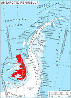
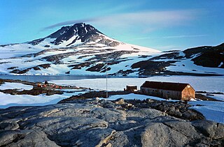
Castle Peak is a prominent ice-covered peak, 2,380 metres (7,800 ft) high, standing immediately south of Murphy Glacier and close off the west side of Avery Plateau in Graham Land. It is shaped like a truncated cone with a rounded summit and rises more than 610 metres (2,000 ft) above the surrounding ice. It was first surveyed in 1946 by the Falkland Islands Dependencies Survey, and so named by them because of its resemblance to a ruined medieval castle.
Mount Aaron is a mountain in the northwest part of the Latady Mountains in Palmer Land. Mapped by United States Geological Survey (USGS) from ground surveys and U.S. Navy air photos, 1961–67. It was named by the Advisory Committee on Antarctic Names (US-ACAN) for W.T. Aaron, electrician with the South Pole Station winter party in 1963.

Simon Peak is a mountain rising to about 1,000 m on the west side of the Havre Mountains, situated in the northwest portion of Alexander Island, Antarctica. The peak lies northeast of Umber Island, an island situated in Lazarev Bay off the west coast of Alexander Island. It is situated 9.9 km east-southeast of Buneva Point, 6.4 km northeast of Kamhi Point, 14.65 km west of Mount Pontida and 6.15 km north-northeast of Gazey Nunatak, and surmounts Pipkov Glacier to the north and Oselna Glacier to the southwest. Possibly sighted by FAE, 1908–10, in January 1909; surveyed by British Antarctic Survey in 1975-76. Named after Alec Edward Simon, British Antarctic Survey aircraft mechanic, who worked on nearby Adelaide Island during the summers of years 1972 to 1976.
Arrowstone Provincial Park is a provincial park in the Thompson Country of the Southern Interior of British Columbia, Canada, located to the northeast of the town of Cache Creek. The park was established by Order-in-Council in 1996 with an area of 6203 hectares. In 2000 its boundaries were slightly reduced, such that its area is now 6175 hectares.

O'Cain Point is a point lying 3 nautical miles (6 km) northwest of Duthoit Point on the east side of Nelson Island, in the South Shetland Islands. The name O'Cain's Island, after the American sealing vessel O'Cain from Boston, MA, was applied by the Stonington sealers in 1820-21 to Nelson Island, but this name did not become established. O'Cain Point was applied by the United Kingdom Antarctic Place-Names Committee (UK-APC) in 1961 to preserve the American name in the area.
Nansen Ice Sheet, or Nansen Ice Shelf, is a 30-mile-long (48 km) by 10-mile-wide (16 km) ice shelf. It is nourished by the Priestley and Reeves Glaciers and abutting the north side of the Drygalski Ice Tongue, along the coast of Victoria Land, Antarctica. This feature was explored by the South Magnetic Polar Party of the British Antarctic Expedition, 1907-09 and by the Northern Party of the British Antarctic Expedition, 1910-13. Frank Debenham, geologist with the latter expedition, applied the name Nansen Sheet as the feature is adjacent to Mount Nansen, the dominating summit in the area.
Mount Borgstrom is a mountain, 2,610 metres (8,560 ft) high, rising 2 nautical miles (4 km) southeast of Mount Meister on Nash Ridge of the Eisenhower Range, in Victoria Land. It was mapped by the United States Geological Survey from surveys and from U.S. Navy air photos, 1955–63, and named by the Advisory Committee on Antarctic Names for Commander Charles O. Borgstrom, an air operations officer with U.S. Navy Squadron VX-6 during Operation Deep Freeze 1966.
Mount Butters is the snowcapped summit, 2,440 metres (8,000 ft) high, of a buttress-type escarpment at the extreme southeast end of Anderson Heights, between Mincey Glacier on the south and Shackleton Glacier on the east. It was discovered and photographed by U.S. Navy Operation Highjump (1946–47) on the flights of February 16, 1947, and named by the Advisory Committee on Antarctic Names for Captain Raymond J. Butters, United States Marine Corps, navigator of Flight 8A.
Norfolk Glacier is a glacier, 12 nautical miles (22 km) long, draining westward from Wisconsin Range to enter Reedy Glacier between mounts Soyat and Bolton. Mapped by United States Geological Survey (USGS) from surveys and U.S. Navy air photos, 1960-64. Named by Advisory Committee on Antarctic Names (US-ACAN) after Norfolk, VA, location of Detachment Three, the Meteorological Support Unit of the U.S. Naval Support Force, Antarctica.

Mount Waldron is a mountain in Antarctica, the summit of Veregava Ridge in the Sentinel Range of Ellsworth Mountains. It is situated 3 nautical miles (6 km) north of Mount Tuck, and surmounts Dater Glacier to the west, Orizari Glacier to the north, Berisad Glacier to the northeast, and Hansen Glacier to the southeast.
Mount Wilbanks is a mound-shaped mountain that is partly ice covered but has a prominent bare rock east face, forming the east extremity of the Kohler Range in Marie Byrd Land in Antarctica. First roughly mapped by United States Geological Survey (USGS) from air photos obtained by U.S. Navy Operation Highjump in January 1947. Named by Advisory Committee on Antarctic Names (US-ACAN) for John R. Wilbanks, geologist with the United States Antarctic Research Program (USARP) Marie Byrd Land Survey party, 1966-67.

Mount Wild is a sharply defined rock ridge with several summits, the highest 945 m, standing at the north side of the entrance to Sjögren Inlet on the east coast of Trinity Peninsula in Graham Land, Antarctica. First charted by the Falkland Islands Dependencies Survey (FIDS) in 1945 and named for Frank Wild.
Krout Glacier is a tributary glacier, 4 nautical miles (7 km) long, draining the north slopes of the Prince Olav Mountains, Antarctica, between Mount Sellery and Mount Smithson and entering Gough Glacier just east of Mount Dodge. It was named by the Advisory Committee on Antarctic Names for Equipment Operator Walter L. Krout, U.S. Navy, of Operation Deep Freeze, 1964.

Dick Glacier is a tributary glacier, 7 nautical miles (13 km) long, flowing west from Mount Campbell to enter Shackleton Glacier just north of Taylor Nunatak, in the Queen Maud Mountains of Antarctica. It was named by the Advisory Committee on Antarctic Names for Lieutenant Alan L. Dick, a member of U.S. Navy Squadron VX-6 during Operation Deep Freeze 1964.
Mount Flower is a mountain with two summits, the highest at 1,465 metres (4,800 ft), standing 6.5 nautical miles (12 km) inland from Carse Point and George VI Sound, on the west coast of Palmer Land, Antarctica. This mountain lies partially within the margin of the area first photographed from the air on November 23, 1935 by Lincoln Ellsworth, and its northern extremity was mapped from these photographs by W.L.G. Joerg. It was first surveyed in 1936 by the British Graham Land Expedition (BGLE) under John Rymill, and was named by the UK Antarctic Place-Names Committee in 1954 for Geoffrey C. Flower, an instructor in survey at the Royal Geographical Society, 1933–40, who helped with the organization and working out of the surveys made by the BGLE, 1934–37.
Greegor Peak is a peak 550 metres (1,800 ft) high 3 nautical miles (6 km) west-southwest of the summit of Mount Passel in the Denfeld Mountains of the Ford Ranges, in Marie Byrd Land, Antarctica. It was mapped by the United States Antarctic Service (1939–41) and by the United States Geological Survey from surveys and U.S. Navy air photos (1959–65). It was named by the Advisory Committee on Antarctic Names for David H. Greegor, a biologist with the United States Antarctic Research Program Marie Byrd Land Survey II, 1967–68.
Mount Lira is a mountain located 5 nautical miles (9 km) east of the Condon Hills, in Enderby Land, Antarctica. The geology of this feature was investigated by the Soviet Antarctic Expedition of 1961–62, which called it "Gora Lira", probably because of its shape.
Mount Hyatt is a mountain in the southern part of the Latady Mountains, about 5 nautical miles (9 km) northwest of Schmitt Mesa, in Palmer Land, Antarctica. It was mapped by the United States Geological Survey from surveys and U.S. Navy air photos, 1961–67, and was named by the Advisory Committee on Antarctic Names for Gerson Hyatt, a builder with the McMurdo Station winter party in 1967, who assisted in building the United States Antarctic Research Program Plateau Station at 79°15′S40°30′E.
Skinner Peak is a mainly snow-covered peak, over 2,600 m, on the spur that descends northeast from Mount Schopf in Ohio Range, Horlick Mountains. Named by Advisory Committee on Antarctic Names (US-ACAN) for Courtney J. Skinner, geological assistant and camp manager with the Ohio State University expedition to the Horlick Mountains in 1961-62. Skinner visited Antarctica with United States Antarctic Research Program (USARP) every summer season from 1961-62 to 1966-67.
Rosselin Glacier is a glacier flowing southwest from the southern extremity of the Rouen Mountains into Palestrina Glacier, situated in the northern portion of Alexander Island, Antarctica. The glacier was first surveyed by the British Antarctic Survey in 1975-76. The feature was named by the United Kingdom Antarctic Place-Names Committee in late 1980 after F. Rosselin, Chief Engineer, FAE, 1908–10, in association with other FAE names in this area.


