Related Research Articles
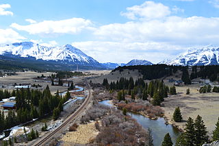
The Crowsnest River is a tributary to the Oldman River in southwestern Alberta, Canada.
Rock Bay Marine Provincial Park is a provincial park in British Columbia, Canada, located on the Inside Passage at the junction of Johnstone Strait and Discovery Passage. The park contains approximately 525 ha. Rock Bay is located on the shore of Vancouver Island, immediately south of East Thurlow Island.
De Winton is a hamlet in southern Alberta, Canada within the Foothills County. It is located just south of the City of Calgary and west of Highway 2A.

Saskatchewan River Crossing is a locality in western Alberta, Canada. It is located within Banff National Park at the junction of Highway 93 and Highway 11. It is administered by Improvement District No. 9.

Cherhill is a hamlet in Alberta, Canada within Lac Ste. Anne County. It is located along Highway 43, approximately 35 kilometres (22 mi) east of Mayerthorpe and 82 kilometres (51 mi) northwest of Edmonton.
Alhambra is a hamlet in Alberta, Canada within Clearwater County. It is located close to the David Thompson Highway, east of Rocky Mountain House.

The Rocky Mountain Foothills are an upland area flanking the eastern side of the Rocky Mountains, extending from the Liard River in British Columbia southward into Alberta. Bordering the Interior Plains system, they are part of the Rocky Mountain System or Eastern System of the Western Cordillera of North America.
Tonquin Pass, 1948 m (6393 ft), is a mountain pass in the Canadian Rockies, linking Tonquin Valley in Jasper National Park, Alberta, to Mount Robson Provincial Park and adjoining areas of British Columbia. It is at the headwaters of Tonquin Creek, which flows into British Columbia. Located on the interprovincial boundary, it is on the Continental Divide.

Alexis 133 is an Indian reserve of the Alexis Nakota Sioux Nation in Alberta, located within Lac Ste. Anne County. It is 70 kilometres northwest of Edmonton. In the 2016 Canadian Census, it recorded a population of 755 living in 173 of its 209 total private dwellings.
The Etherington Formation is a geologic formation in Alberta. It preserves fossils dating back to the Carboniferous period.
Mount Barwell is a summit in Alberta, Canada.
Mount Burney is a summit in Alberta, Canada.
Mount Burns is a summit in Alberta, Canada.
Cyclamen Ridge is a ridge in Alberta, Canada.
Mount Dyson is a summit in Alberta, Canada.
Fallentimber Creek is a stream in Alberta, Canada. It area is of 66 acres.
Fawcett River is a stream in Alberta, Canada.
Gravenstafel Ridge is a ridge in Alberta, Canada.
Isola Peak is a summit in Alberta, Canada.
References
- ↑ "Mount Burke". Geographical Names Data Base . Natural Resources Canada.
- ↑ Place-names of Alberta. Ottawa: Geographic Board of Canada. 1928. p. 27.
50°17′24″N114°31′30″W / 50.290°N 114.525°W
| | This article related to a mountain, mountain range, or peak in Canada is a stub. You can help Wikipedia by expanding it. |
| | This Alberta's Rockies location article is a stub. You can help Wikipedia by expanding it. |