
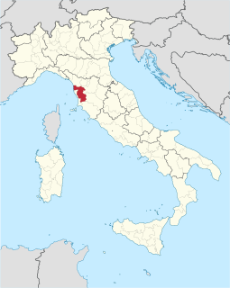
The Province of Caserta is a province in the Campania region of southern Italy. Its capital is the city of Caserta, situated about 36 kilometres (22 mi) by road north of Naples. The province has an area of 2,651.35 square kilometres (1,023.69 sq mi), and a total population of 924,414 as of 2016. The Palace of Caserta is located near to the city, a former royal residence which was constructed for the Bourbon kings of Naples. It was the largest palace and one of the largest buildings erected in Europe during the 18th century. In 1997, the palace was designated a UNESCO World Heritage Site.
The province of Pisa is a province in the Tuscany region of central Italy. Its capital is the city of Pisa. With an area of 2,448 square kilometres (945 sq mi) and a total population of 421,642, it is the second most populous and fifth largest province of Tuscany. It is subdivided into 37 comuni.
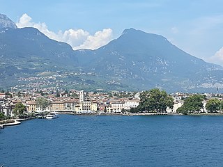
Riva del Garda is a town and comune in the northern Italian province of Trento of the Trentino Alto Adige region. It is also known simply as Riva and is located at the northern tip of Lake Garda.

San Biagio Saracinisco is a comune (municipality) in the Province of Frosinone in the Italian region of Lazio, located about 120 kilometres (75 mi) east of Rome and about 50 kilometres (31 mi) east of Frosinone.

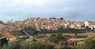
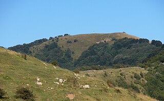
Cammarata is a comune (municipality) in the Province of Agrigento in the Italian region Sicily, located about 60 kilometres (37 mi) southeast of Palermo and about 35 kilometres (22 mi) north of Agrigento on the eponymous mountain, which has an elevation 1,578 metres (5,177 ft) above sea level in a territory rich in forests.
Cianciana is a comune (municipality) in the Province of Agrigento in the Italian region Sicily, located in the middle valley of the Platani river, about 70 kilometres (43 mi) south of Palermo and about 25 kilometres (16 mi) northwest of Agrigento. The Monte Cammarata, elevation 1,579 metres (5,180 ft) above sea level, part of the Monti Sicani chain, is nearby.
San Giovanni Gemini is a comune (municipality) in the Province of Agrigento in the Italian region Sicily, located about 60 kilometres (37 mi) southeast of Palermo and about 35 kilometres (22 mi) north of Agrigento.

Monte Titano is a mountain of the Apennines and the highest peak in San Marino. It stands 739 m (2,425 ft) above sea level and is located immediately to the east of the capital, San Marino. It was inscribed as a UNESCO World Heritage Site in 2008 under the combined title "San Marino Historic Centre and Mount Titano". Inscribed under reference no. 1245 criteria iii, the two together encompass an area of 55 ha with a buffer zone of 167 ha. It encompasses Mount Titano and the other structures such as the fortification towers, walls, gates and bastions, as well as a neo-classical basilica located on it and its slopes forming a small but unique urban conglomerate.

The Monti Sicani are a mountain chain in the central-southern Sicily, southern Italy, included between the Agrigento and Palermo. The name also indicates a series of comuni (municipalities) lying in the area.
Monte Buio is a mountain in Liguria, northern Italy, part of the Ligurian Appennines. It is located between the provinces of Genoa and Alessandria. It lies at an altitude of 1400 metres.
Monte Rama is a mountain in Liguria, northern Italy, part of the Ligurian Appennines.
The Monti Marsicani are the sixth-highest group of Apennines located in the Abruzzo region, mostly in the Province of L’Aquila and partly in the Province of Frosinone and Province of Isernia. The highest peak is Monte Greco (2285m). They are limited in north by the Fucino plateau and Peligna Valley, on the east by the River Gizio and Altopiano delle Cinque Miglia, on the south by the Valley Sangro and Volturno, on the east by valley Liri and Melfa.

Rocca Busambra is the highest peak in the Monti Sicani, in western Sicily, southern Italy. It has an elevation of 1,613 metres (5,292 ft).
Cima Fontanaccia is a 1153 metres high mountain in the Ligurian Apennines, in Italy.
Mount Bonifato is a mountain in north western Sicilly in the province of Trapani.

Monte Barraù is a mountain in the Monti Sicani, in Sicily, southern Italy. It has an elevation of 1,420 metres (4,659 ft), giving it the fourth highest elevation in the Monti Sicani after Rocca Busambra, Monte Cammarata and Monte delle Rose.

Ficuzza is a southern Italian village and hamlet (frazione) of Corleone, a municipality in the Metropolitan City of Palermo, Sicily. in 2011 it had a population of 112.

Cadet Peak is a 7,186 ft mountain summit near the western edge of the North Cascades, in Snohomish County of Washington state. The peak is located southeast of Barlow Pass along the Mountain Loop Highway, and two miles east of the historic Monte Cristo area. It is situated within the Henry M. Jackson Wilderness, on land administered by the Mount Baker-Snoqualmie National Forest. The mountain was originally called Foggy Peak, for the Foggy Mine claim on the mountain's north slope, but the name was changed in 1896 to its present name, and the Foggy Peak name was transferred to the peak immediately northwest of Cadet. Back in the old mining days, the long sub-range stretching from Cadet Peak to Sheep Mountain was known as Pride of the Mountains Range. Cadet's nearest higher neighbor is Kyes Peak, 1.59 mi (2.56 km) to the south-southeast. Precipitation runoff from the mountain drains into tributaries of the Sauk River.

The Italian geographical region, Italian physical region or Italian region is a geographical region of Southern and Western Europe delimited to the north and west by the mountain chains of the Alps. This region is composed of a continental part in the north, a main peninsular part and an insular part in the south. Located between the Balkan Peninsula and the Iberian Peninsula, it protrudes into the center of the Mediterranean Sea and overlooks the Adriatic Sea, Ionian Sea, Ligurian Sea, the Sardinian Channel, the Sea of Corsica, Sea of Sardinia, Strait of Sicily and the Tyrrhenian Sea.

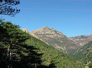
Monte San Petrone is a mountain in the department of Haute-Corse on the island of Corsica, France. It is the highest mountain in the Monte San Petrone massif, the southernmost of the schist massifs of the northeast of the island.
