Mount Dainichi

Last updated
Mount Dainichi
大日ヶ岳
Mount Dainichi from Mount Shirao 2008-3-23.JPG
Mount Dainichi from Mount Shirao
Highest point
Elevation 1,709 m (5,607 ft)
Coordinates 36°00′05″N136°50′16″E / 36.00139°N 136.83778°E / 36.00139; 136.83778 Coordinates: 36°00′05″N136°50′16″E / 36.00139°N 136.83778°E / 36.00139; 136.83778
Geography
Location Gujō and Takayama, Gifu Prefecture, Japan
Parent range Ryōhaku Mountains
Climbing
First ascent Taichō in 717

Mount Dainichi(大日ヶ岳,Dainichi-ga-take) is a mountain located in the cities of Gujō and Takayama in Gifu Prefecture, Japan. It is part of the Ryōhaku Mountains and has a height of 1,709 m (5,607 ft). The rain that falls on the mountain flows into three rivers: the Nagara River, the Shō River and the Kuzuryū River.

Gujō, Gifu City in Chūbu, Japan

Gujō is a city located in Gifu, Japan. As of 1 February 2019, the city had an estimated population of 41,858, and a population density of 41 persons per km2, in 15,341 households. The total area of the city was 851.21 square kilometres (328.65 sq mi).

Takayama, Gifu City in Chūbu, Japan

Takayama is a city located in Gifu, Japan. As of 1 January 2019, the city had an estimated population of 88,473 in 35,644 households, and a population density of 41 persons per km2. The total area of the city was 2,177.61 square kilometres (840.78 sq mi). The high altitude and separation from other areas of Japan kept the area fairly isolated, allowing Takayama to develop its own culture over about a 300-year period.

Gifu Prefecture Prefecture of Japan

Gifu Prefecture is a prefecture in the Chūbu region of central Japan. Its capital is the city of Gifu.

Contents

History

Taichō (泰澄, 682–April 20, 767) was the first person to climb Mount Dainichi in 717. From the peak of the mountain, hikers can pray to nearby Mount Haku.

Taichō was a shugendō monk in Nara period Japan. He was raised in Echizen Province, which was in the southern portion of present-day Fukui Prefecture. He was the second son of Mikami Yasuzumi (三神安角). He is said to be the first person to reach the top of Mount Haku in neighboring Kaga Province and other peaks in the Ryōhaku Mountains.

Mount Haku mountain in Ishikawa Prefecture, Japan

Mount Haku, or Mount Hakusan, is a dormant volcano. The stratovolcano is located on the borders of Gifu and Ishikawa prefectures in Japan. It is thought to have first been active 300,000 to 400,000 years ago, with the most recent eruption occurring in 1659. Along with Mount Tate and Mount Fuji, it is one of Japan's "Three Holy Mountains".

In pre-modern Japan, Mount Dainichi formed part of the border between Mino, Hida and Echizen provinces. Originally located in the village of Itoshiro in Fukui Prefecture, it became part of Gifu Prefecture during the "Great Shōwa Mergers" in 1958. It was first part of the town of Shirotori, which was later merged into the city of Gujō.

Mino Province one of the old provinces of Japan, encompassed part of modern-day Gifu Prefecture


Mino Province, one of the old provinces of Japan, encompassed the southern part of modern-day Gifu Prefecture. It was sometimes called Nōshū (濃州). Mino Province bordered Echizen, Hida, Ise, Mikawa, Ōmi, Owari, and Shinano Provinces.

Hida Province province of Japan

Hida Province was a province of Japan in the area that is today the northern portion of Gifu Prefecture in the Chūbu region of Japan. Hida bordered on Echizen, Mino, Shinano, Etchū, and Kaga Provinces. It was part of Tōsandō Circuit. Its abbreviated form name was Hishū (飛州). Under the Engishiki classification system, Hida was ranked as a "inferior country" (下国) and a middle country (中国) in terms of its importance and distance from the capital. Currently, the entire area of the former Hida Province consists of the cities of Hida, Takayama and most of the city of Gero, and the village of Shirakawa, in Ōno District.

Echizen Province province of Japan

Echizen Province was a province of Japan in the area that is today the northern portion of Fukui Prefecture in the Hokuriku region of Japan. Echizen bordered on Kaga, Wakasa, Hida, and Ōmi Provinces. It was part of Hokurikudō Circuit. Its abbreviated form name was '.

Related Research Articles

Seki, Gifu City in Chūbu, Japan

Seki is a city located in Gifu, Japan. As of 1 January 2019, the city had an estimated population of 89,020 and a population density of 190 persons per km2 in 35,366 households.. The total area of the city was 472.33 square kilometres (182.37 sq mi).

Mizuho, Gifu City in Chūbu, Japan

Mizuho is a city located in Gifu, Japan. As of 30 November 2018, the city had an estimated population of 54,686 and a population density of 1900 persons per km2, in 20866 households. The total area of the city was 28.19 square kilometres (10.88 sq mi).

Ōno, Fukui City in Chūbu, Japan

Ōno is a city located in Fukui Prefecture, Japan. As of 1 July 2018, the city had an estimated population of 33,640 in 11,747 households and the population density of 39 persons per km². The total area of the city was 872.43 square kilometres (336.85 sq mi). The town is encircled by a ring of mountains and the only way in or out is via tunnels or mountain roads.

Gero, Gifu City in Chūbu, Japan

Gero is a city located in Gifu, Japan. As of 31 October 2017, the city had an estimated population of 33,283, and a population density of 39 persons per km2, in 12,253 households. The total area of the city was 851.21 square kilometres (328.65 sq mi). The city is famous for its hot springs.

Mino, Gifu City in Chūbu, Japan

Mino is a city located in Gifu, Japan. As of 31 December 2018, the city had an estimated population of 20,749 in 8149 households, and a population density of 180 persons per km2. The total area of the city was 117.01 square kilometres (45.18 sq mi). The city is renowned for traditional Japanese Mino washi paper and its streets, which are in the style of the early Edo period (1603–1868). An urban area known as "Udatsu Townscape" (うだつのあがるまちなみ) is designated as an important traditional building group conservation area by the government on May 13, 1999.

Hakusan National Park national park of Japan

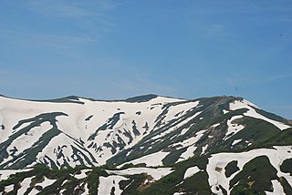
Hakusan National Park is a national park in the Chūbu region of Honshū, Japan. Established in 1962, it spans the borders of Fukui, Gifu, Ishikawa, and Toyama prefectures. Its main geographical feature is Mount Haku. In 1980 an area of 480 km² corresponding to the national park was designated a UNESCO Man and the Biosphere Reserve.

Japan National Route 472 road in Japan

National Route 472 is a highway between Imizu, Toyama Prefecture and Gujo, Gifu Prefecture in Japan.

Nagara River river flows thorough Chubu region of Japan

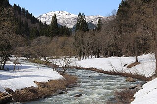
The Nagara River has its source in the city of Gujō, Gifu Prefecture, and its mouth in the city of Kuwana, Mie Prefecture, Japan. Along with the Kiso River and Ibi River, the Nagara River is one of the Kiso Three Rivers of the Nōbi Plain. Previously, the river was named Sunomata River. With a length of 166 km (103 mi), it drains an area of 1,985 square kilometres (766 sq mi) in the Chūbu region and empties into Ise Bay. The government of Japan classifies it as a Class 1 river.

The Hirugano Botanical Garden is a botanical garden located in the skiing region near Mount Dainichi in the Takasu area of the city of Gujō, Gifu Prefecture, Japan.

Gujō Hachiman Castle building in Gujo, Gifu Prefecture, Japan

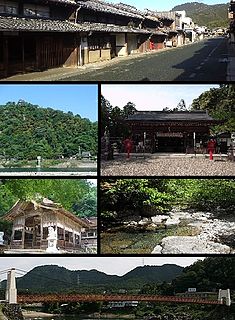
Gujō Hachiman Castle is a yamashiro, or mountain castle, located on Hachiman Mountain in Gujō, Gifu Prefecture, Japan.

Takasu, Gifu human settlement in Japan

Takasu was a village located in Gujō District, Gifu Prefecture, Japan.

Itoshiro River river in Japan

The Itoshiro River is a river through Gifu and Fukui prefectures in Japan.

Chūnō

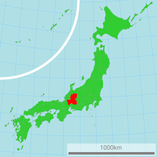
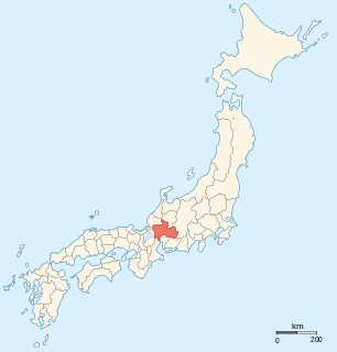
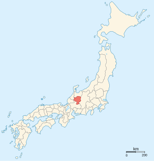
Chūnō (中濃) is the central portion of Gifu Prefecture in the Chūbu region of Japan. Before Gifu became a prefecture, the area was part of Mino Province. The Chūnō region received its name as a combination of the kanji for "middle" (中) and "Mino" (美濃). The borders of this region are not officially set, but it generally consists of thirteen municipalities. There are five cities in addition to the towns and village in the Kamo and Kani (Mitake) districts also fall into the Chūnō region. Occasionally, Gujō is separated from the Chūnō region and is said to be part of the Hokunō region.

Mount Bessan mountain in Ishikawa Prefecture, Japan

Mt. Bessan is located on the border of Gujō, Gifu Prefecture, and Hakusan, Ishikawa Prefecture, Japan, and rises to a height of 2,399 m (7,871 ft). There are two triangulation stations at the top of the mountain. Mount Haku can be seen from the north. Bessan Shrine is a short distance from the peak. This area is part of Hakusan National Park.(Note: there is a second Mt. Bessan in located in Toyama Prefecture.)

Mount Sannomine mountain in Japan

Mt. Sannomine is located on the border of Gujō, Gifu Prefecture, and Hakusan, Ishikawa Prefecture, Japan, and rises to a height of 2,128 m (6,982 ft).

Mount Iide mountain in Fukushima Prefecture, Japan

Mount Iide is the main peak of the Iide mountain range that spans the Fukushima, Niigata and Yamagata prefectures in Japan. On top of the mountain stands the Mount Iide Shrine (飯豊山神社). Mount Iide is, together with the rest of the range, one of the mountains described in Kyūya Fukada's book 100 Famous Japanese Mountains.

References