Related Research Articles

The Nevis River is in Otago, New Zealand. It flows north for 40 kilometres (25 mi) through rough country before meeting the Kawarau River, of which it is a tributary. A prominent rock outcrop close to this junction is known as the Nevis Bluff.
The Dennistoun Glacier is a glacier, 50 nautical miles long, draining the northern slopes of Mount Black Prince, Mount Royalist and Mount Adam in the Admiralty Mountains of Victoria Land, Antarctica. It flows northwest between the Lyttelton Range and Dunedin Range, turning east on rounding the latter range to enter the sea south of Cape Scott.
The Supporters Range is a rugged range in the Queen Maud Mountains of Antarctica. It is 25 nautical miles long, bordering the eastern side of Mill Glacier, from Keltie Glacier in the north to Mill Stream Glacier in the south. So named by the New Zealand Geological Survey Antarctic Expedition (NZGSAE) (1961–62) because several peaks of the range are named after supporters of Ernest Shackleton's British Antarctic Expedition (1907–09).
Tucker Glacier is a major valley glacier of Victoria Land, Antarctica, about 90 nautical miles long, flowing southeast between the Admiralty Mountains and the Victory Mountains to the Ross Sea. There is a snow saddle at the glacier's head, just west of Homerun Range, from which the Ebbe Glacier flows northwestward.
The Victory Mountains is a major group of mountains in Victoria Land, Antarctica, about 100 nautical miles long and 50 nautical miles wide, which is bounded primarily by Mariner and Tucker glaciers and the Ross Sea. They are north of the Mountaineer Range, east of the Freyberg Mountains and south of the Concord Mountains and the Admiralty Mountains. The division between the Victory Mountains and the Concord Mountains is not precise but apparently lies in the vicinity of Thomson Peak.
Jacquemart Island, one of the islets surrounding Campbell Island in New Zealand, lies 1 km south of Campbell Island and is the southernmost island of New Zealand.

Dent Island is a subantarctic 26-hectare (64-acre) rock stack, lying 3 km west of Campbell Island and belonging to the Campbell Island group. Dent Island is located at 52°31.15′S169°3.75′E. It was named by the French 1874 Transit of Venus Expedition to Campbell Island because of its resemblance to a tooth.
The Mariner Glacier is a major glacier over 60 nautical miles long, descending southeast from the plateau of Victoria Land, Antarctica, between Mountaineer Range and Malta Plateau, and terminating at Lady Newnes Bay, Ross Sea, where it forms the floating Mariner Glacier Tongue.
The Mountaineer Range is the range of mountains lying between the Mariner Glacier and Aviator Glacier in Victoria Land, Antarctica. It lies to the south of the Victory Mountains and northeast of the Southern Cross Mountains.

Folly Island or the Folly Islands is a subantarctic island located in New Zealand's Campbell Island group.

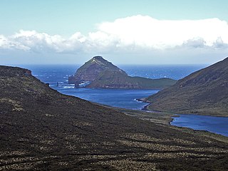
Mount Honey is the highest point on Campbell Island, the southernmost of New Zealand's subantarctic outlying islands. It is located to the south of Perseverance Harbour, a long lateral fissure which reaches the ocean in the island's southeast, and rises to a height of 558 metres (1,831 ft).
Venus Bay is located on Perseverance Harbour on New Zealand's subantarctic Campbell Island. It was named for an 1874 French astronomical expedition to view the Transit of Venus, which set up camp at the site. As a result of the expedition, many of Campbell Island's landforms have French names, including Mount Fizeau and Mount Dumas.
Mount Fizeau is located on New Zealand's subantarctic Campbell Island. It was named by members of the 1874 French astronomical expedition to view the Transit of Venus, which set up on the island at Venus Bay. Mount Fizeau rises to a height of 497 metres (1655 ft), and is the second-highest point on the island.

Robertson Bay is a large, roughly triangular bay that indents the north coast of Victoria Land between Cape Barrow and Cape Adare. Discovered in 1841 by Captain James Clark Ross, Royal Navy, who named it for Dr. John Robertson, surgeon on HMS Terror.
Daniell Peninsula is the large peninsula between Cape Daniell and Cape Jones on the coast of Victoria Land, Antarctica. It is an elongated basalt dome similar to Adare Peninsula and Hallett Peninsula and rises to 2,000 metres (6,600 ft). It is partly separated from the Victory Mountains by Whitehall Glacier, which is afloat in its lower reaches, but is joined to these mountains by the higher land in the vicinity of Mount Prior. It was named by the New Zealand Geological Survey Antarctic Expedition (NZGSAE), 1957–58, after Cape Daniell, and by analogy with the Adare and Hallett peninsulas.
Mūmū Nunatak is a nunatak in the north part of Kyle Hills, Ross Island. The feature is 2 nautical miles (3.7 km) west-southwest of Towle Point and 0.6 nautical miles (1.1 km) inland from steep cliffs that form the northeast edge of the island. The name Mūmū is one of several Maori wind names applied by New Zealand Geographic Board (NZGB) in this area.
Moubray Bay is a bay in the western Ross Sea, indenting the coast of Victoria Land, Antarctica, between Cape Roget and Cape Hallett. It was discovered in 1841 by Sir James Clark Ross and named by him for George H. Moubray, clerk in charge of the expedition ship Terror.
Cape Lyttelton is a cape forming the southern entrance point of Shackleton Inlet, along the western edge of the Ross Ice Shelf, Antarctica.
References
- Te Ara: The Encyclopedia of New Zealand – Campbell Island Landscapes
- National Library of New Zealand – View of Mt Dumas, Campbell Island, ca 1956
52°34′S169°04′E / 52.567°S 169.067°E
| | This article about the geography of New Zealand's outlying islands is a stub. You can help Wikipedia by expanding it. |