The protected areas of the Northern Territory consists of protected areas managed by the governments of the Northern Territory and Australia and private organisations with a reported total area of 335,527 square kilometres (129,548 sq mi) being 24.8% of the total area of the Northern Territory of Australia.
Litchfield National Park, covering approximately 1500 km2, is near the township of Batchelor, 100 km south-west of Darwin, in the Northern Territory of Australia. Each year the park attracts over 260,000 visitors.

Pine Creek is a small town in the Katherine region of the Northern Territory, Australia. As at the 2021 Census there were 319 residents of Pine Creek, which is the fourth largest town between Darwin and Alice Springs.

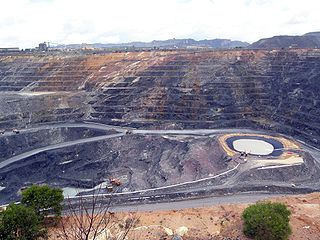
Rum Jungle is a locality in the Northern Territory of Australia located about 105 kilometres south of Darwin on the East Branch of the Finniss River. It is the site of a uranium deposit, found in 1949, which has been mined.
Compass Resources NL is an Australian mining and mineral exploration company listed on the Australian Stock Exchange and currently in voluntary administration since 29 January 2009.
Alpurrurulam, from the original Aboriginal name Ilperrelhelame, also known as Lake Nash, is a locality in the Northern Territory of Australia located in the territory's east about 1,206 kilometres (749 mi) south-east of the territory capital of Darwin and about 570.1 kilometres (354.2 mi) east of the municipal seat of Tennant Creek and about 17 kilometres (11 mi) from the border with the state of Queensland. The town is at the end of the Sandover Highway, which floods each year during the wet season and cuts all road access to the community.

The Coomalie Community Government Council is a local government area in Australia's Northern Territory, situated south of Darwin and Palmerston. The council governs an area of 2,056 km2 (794 sq mi). The shire had a population of 1,391 in June 2018.

Batchelor is a town in the Northern Territory of Australia. The town is the current seat and largest town of the Coomalie Shire local government area. It is located 98 kilometres (61 mi) south of the territory capital, Darwin. A number of residents commute to Darwin and its suburbs for work.

The Browns polymetallic ore deposit is a large ore deposit located at Mount Fitch, near Batchelor, 64 kilometres south of Darwin, Northern Territory, Australia.

Howard Springs is a locality in the Northern Territory. It is 29 kilometres (18 mi) SE of the Darwin CBD. Its local government area is the Litchfield Municipality. The suburb is mostly a rural area, but has been experiencing strong growth in population and development. From 2020, it has housed a major quarantine facility.

Radioactive ores were first extracted in South Australia at Radium Hill in 1906 and Mount Painter in 1911. 2,000 tons of ore were treated to recover radium for medical use. Several hundred kilograms of uranium were also produced for use in ceramic glazes.

The Daly River is a river in the Northern Territory of Australia. It is part of the Daly Catchment.

The Finniss River is a river south of Darwin, running west from the flank of Mount Minza, passing north of Litchfield National Park and flowing into the sea at Fog Bay. The East Branch of the Finniss was heavily polluted during the 1970s due to uranium mining at Rum Jungle mine about 105 km south of Darwin. The Finniss River Land Claim was presented to Judge John Toohey in 1981 but the former Rum Jungle mine site, contained within Area 4 of the Finniss River Land Claim (1981) was excluded from the grant to the Finniss River Land Trust due to the concerns of the Kungarakany and Warai peoples who are joint traditional Aboriginal owners of that area.
The Awarai (Warray) are an indigenous Australian people of the Northern Territory.
The Kungarakany people, also spelt Koongurrukuñ, Kungarrakany, Kungarakan and other variants, are an Aboriginal Australian people of the Northern Territory. They were called the "Paperbark People" by European settlers.
Mount Bundey is a locality in the Northern Territory of Australia located about 115 kilometres (71 mi) east of the territory capital of Darwin.
Micket Creek is a locality in the Northern Territory of Australia located about 12 kilometres (7.5 mi) east of the territory capital of Darwin.
Daly is a locality in the Northern Territory of Australia located about 51 kilometres (32 mi) south-east of the territory capital of Darwin.

Anmatjere is a locality in the Northern Territory of Australia located about 1,088 kilometres (676 mi) south of the territory capital of Darwin.


