Darwin is the capital city of the Northern Territory, Australia. With a population of 139,902 at the 2021 census, the city contains most of the sparsely populated Northern Territory's residents. It is the smallest, wettest, and most northerly of the Australian capital cities and serves as the Top End's regional centre.

Humpty Doo is a town in Australia's Northern Territory, situated just south of the Arnhem Highway, approximately 40 km from Darwin. At the 2016 census, Humpty Doo had a population of 4,313 people. Its local government area is Litchfield Municipality. The town is a popular stopping point for tourists travelling between Darwin and Kakadu National Park, and boasts many attractions of its own. The main industries are agriculture and tourism; however, most residents commute to Darwin or Palmerston for work, and many regard it as a dormitory town.
Palmerston is a planned satellite city of Darwin, the capital and largest city of Australia's Northern Territory. The city is situated approximately 20 kilometres from Darwin and 10 kilometres from Howard Springs and the surrounding rural areas. Palmerston had a population of 33,695 at the 2016 census, making it the second largest city in the Northern Territory.

Darwin Harbour is a body of water close to Darwin in the Northern Territory of Australia. It opens to the north at a line from Charles Point in the west to Lee Point in the east into the Beagle Gulf and connects via the Clarence Strait with the Van Diemen Gulf. It contains Port Darwin, which is flanked by Frances Bay to the east and Cullen Bay to the west.

Warragamba Dam is a heritage-listed dam in the outer South Western Sydney suburb of Warragamba, Wollondilly Shire in New South Wales, Australia. It is a concrete gravity dam, which creates Lake Burragorang, the primary reservoir for water supply for the city of Sydney. The dam wall is located approximately 65 kilometres (40 mi) W of Sydney central business district, 4½ km SW of the town of Wallacia, and 1 km NW of the village of Warragamba.

The Upper Nepean Scheme is a series of dams and weirs in the catchments of the Cataract, Cordeaux, Avon and Nepean rivers of New South Wales, Australia. The scheme includes four dams and two weirs, and a gravity-fed canal system that feeds into a large storage reservoir to provide water to the Macarthur and Illawarra regions, the Wollondilly Shire, and metropolitan Sydney. The four dams and associated infrastructure are individually listed on the New South Wales State Heritage Register.
Mount Fitch is a former uranium mining site located in the Northern Territory of Australia 56 kilometres SSE from the centre of Darwin and 13.4 kilometres NE from the town of Batchelor in the locality of Rum Jungle.

The Baroon Pocket Dam is a rock and earth-fill embankment dam with an un-gated spillway across the Obi Obi Creek, in North Maleny, Sunshine Coast Region, in South East Queensland, Australia. The main purpose of the dam is for potable water supply. The impounded reservoir is called Lake Baroon.
Leanyer is a northern suburb of Darwin, in the Northern Territory of Australia.

Howard Springs is a locality in the Northern Territory. It is 29 kilometres (18 mi) SE of the Darwin CBD. Its local government area is the Litchfield Municipality. The suburb is mostly a rural area, but has been experiencing strong growth in population and development. From 2020, it has housed a major quarantine facility.
The Calvert River is a river in the Northern Territory of Australia.
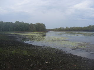
Blackmore River flows into Darwin Harbour close to Darwin in the Northern Territory of Australia.
The Tod Reservoir is located on the Eyre Peninsula in South Australia, in the localities of Whites Flat and Koppio, 27 km north of Port Lincoln. It is situated on the Tod River, the only stream on Eyre Peninsula, South Australia providing reliable flows; the reservoir is supplied by concrete channels fed from weirs constructed across the Tod River and its major tributary, Pillaworta Creek. The river was named after Robert Tod, who discovered it during explorations in 1839. The Tod River flows into Louth Bay in Spencer Gulf. The reservoir is listed on the South Australian Heritage Register.
The Wildman River is a river in the Darwin Coastal bioregion of the Northern Territory, Australia.
Liverpool River is a river in the Northern Territory of Australia. It is the largest of the tidal river systems of northern Arnhem Land, which includes two major tributaries, the Tomkinson and Mann Rivers.
The Walker River is a river in the Northern Territory, Australia.
The Black Jungle Conservation Reserve is a protected area in the Northern Territory of Australia near the territorial capital of Darwin. The rural area of Darwin and its development has a contrasting history to the more southern regions and their rural zones. The development of the rural area around Darwin occurred after 1950 as agricultural ventures were trialed. Prior to this the area was tropical savanna with pockets of monsoon rainforest and melaleuca swamps, unchanged for thousands of years, except by the traditional Aboriginal owners of the land who hunted and gathered and managed the landscape with fire. Black Jungle Conservation Reserve is a part of the Adelaide River Coastal Floodplain system which encompasses Black Jungle and Lambells Lagoon Conservation Reserves, Fogg Dam, Leaning Tree Lagoon Nature Park, Melacca Swamp and Djukbinj National Park. These Reserves encompass a range of wetland types and form part of the internationally significant Adelaide River floodplain.
The Settlement Creek is a creek in the Northern Territory and the state of Queensland, Australia.
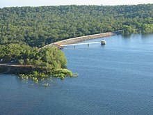
Manton Dam is a small concrete arch dam on the Manton River, approximately 70 km (43 mi) south of Darwin, Northern Territory in Australia. The dam was originally constructed by the Department of Defence during the Second World War to provide a reliable supply of fresh water to Darwin, completed in 1942. The reservoir itself is now mostly used for recreation, such as fishing, boating and water skiing, surrounded by a conservation area for native flora and fauna.