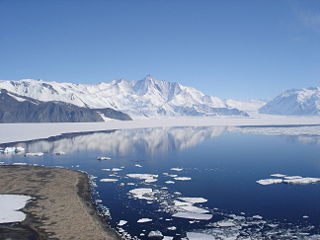
The Admiralty Mountains is a large group of high mountains and individually named ranges and ridges in northeastern Victoria Land, Antarctica. This mountain group is bounded by the Ross Sea, the Southern Ocean, and by the Dennistoun, Ebbe, and Tucker glaciers. The mountain range is situated on the Pennell Coast, a portion of Antarctica lying between Cape Williams and Cape Adare.

The Queen Elizabeth Range is a rugged mountain range of the Transantarctic Mountains System, located in the Ross Dependency region of Antarctica.
The Geologists Range is a mountain range about 55 km (34 mi) long, standing between the heads of Lucy and Nimrod Glaciers in Antarctica. Seen by the northern party of the New Zealand Geological Survey Antarctic Expedition (NZGSAE) (1961–62) and named to commemorate the work of geologists in Antarctic exploration.

The Queen Alexandra Range is a major mountain range of the Transantarctic Mountains System, located in the Ross Dependency region of Antarctica.

The Churchill Mountains are a mountain range group of the Transantarctic Mountains System, located in the Ross Dependency region of Antarctica. They border on the western side of the Ross Ice Shelf, between Byrd Glacier and Nimrod Glacier.

Lillie Glacier is a large glacier in Antarctica, about 100 nautical miles (190 km) long and 10 nautical miles (19 km) wide. It lies between the Bowers Mountains on the west and the Concord Mountains and Anare Mountains on the east, flowing to Ob' Bay on the coast and forming the Lillie Glacier Tongue.

The Scaife Mountains is a group of mountains rising west of Prehn Peninsula and between the Ketchum and Ueda glaciers, in Palmer Land, at the base of Antarctic Peninsula.

The Usarp Mountains is a major Antarctic mountain range, lying westward of the Rennick Glacier and trending N-S for about 190 kilometres (118 mi). The feature is bounded to the north by Pryor Glacier and the Wilson Hills. Its important constituent parts include Welcome Mountain, Mount Van der Hoeven, Mount Weihaupt, Mount Stuart, Mount Lorius, Smith Bench, Mount Roberts, Pomerantz Tableland, Daniels Range, Emlen Peaks, Helliwell Hills and Morozumi Range.

The Scott Mountains are a large number of isolated peaks lying south of Amundsen Bay in Enderby Land of East Antarctica, Antarctica. Discovered on 13 January 1930 by the British Australian New Zealand Antarctic Research Expedition (BANZARE) under Sir Douglas Mawson. He named the feature Scott Range after Captain Robert Falcon Scott, Royal Navy. The term mountains is considered more appropriate because of the isolation of its individual features.
The Humboldt Mountains are a group of mountains immediately west of the Petermann Ranges, forming the westernmost portion of the Wohlthat Mountains in Queen Maud Land, Antarctica.
Wilson Hills is a group of scattered hills, nunataks and ridges that extend NW-SE for about 110 kilometres (68 mi) between Matusevich Glacier and Pryor Glacier in Antarctica. They were discovered by Lieutenant Harry Pennell, Royal Navy, on the Terra Nova Expedition in February 1911 during Robert Falcon Scott's last expedition, and named after Dr. Edward A. Wilson, a zoologist with the expedition, who perished with Scott on the return journey from the South Pole.

Explorers Range is a large mountain range in the Bowers Mountains of Victoria Land, Antarctica, extending from Mount Bruce in the north to Carryer Glacier and McLin Glacier in the south. Named by the New Zealand Antarctic Place-Names Committee (NZ-APC) for the northern party of New Zealand Geological Survey Antarctic Expedition (NZGSAE), 1963–64, whose members carried out a topographical and geological survey of the area. The names of several party members are assigned to features in and about this range. All of the geographical features listed below lie situated on the Pennell Coast, a portion of Antarctica lying between Cape Williams and Cape Adare.
Mount Widerøe is a large mountain rising to 2,994 m between Mount Walnum and Mount Nils Larsen in the Sør Rondane Mountains on the continent of Antarctica.

The Sverdrup Mountains are a group of mountains about 80 km (50 mi) long, standing just west of the Gjelsvik Mountains in Queen Maud Land, East Antarctica. With its summit at 2,655 metres (8,711 ft), the massive Mount Krüger forms the highest point in the Sverdrup Mountains.
Mount Neustruyev is a peak in East Antarctica, 2,900 m, standing 5 mi NNE of Gneiskopf Peak in Südliche Petermann Range, Wohlthat Mountains, Queen Maud Land.

The Gruber Mountains are a small group of mountains consisting of a main massif and several rocky outliers, forming the northeast portion of the Wohlthat Mountains in Queen Maud Land, Antarctica. They were discovered and plotted from air photos by the Third German Antarctic Expedition (GerAE), 1938–39, under Alfred Ritscher. The mountains were remapped by the Sixth Norwegian Antarctic Expedition, 1956–60, who named them for Otto von Gruber, the German cartographer who compiled maps of this area from air photos taken by the GerAE. This feature is not to be confused with "Gruber-Berge," an unidentified toponym applied by the GerAE in northern the Mühlig-Hofmann Mountains.
The Östliche Petermann Range is one of the Petermann Ranges, trending in a north-south direction for 15 nautical miles (28 km) from Per Spur to the Gornyye Inzhenery Rocks, in the Wohlthat Mountains of Queen Maud Land. It was discovered and plotted from air photos by German Antarctic Expedition of 1938–39, and so named by them for its eastern location in the Petermann Ranges.
Mount Schicht is a prominent mountain with several summits, rising 4 nautical miles (7 km) west-southwest of Ritscher Peak in the Gruber Mountains of Queen Maud Land. The feature was discovered by the German Antarctic Expedition under Ritscher, 1938–39, and named Schichtberge because of its appearance.


