Monroe or Monroes may refer to:

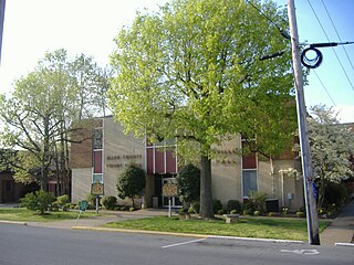
Monroe County is a county located in the Eastern Pennyroyal Plateau region of the U.S. state of Kentucky. Its county seat is Tompkinsville. The county is named for President James Monroe. It was a prohibition or dry county until November 7, 2023, when voters approved the sale of alcohol.
Allen County is a county located in the U.S. state of Kentucky. As of the 2020 census, the population was 20,588. Its county seat and only municipality is Scottsville. The county is named for Colonel John Allen, a state senator and soldier who was killed leading the 1st Regiment of Kentucky Rifleman at the Battle of Frenchtown, Michigan during the War of 1812. Allen County was a dry county until 2023, when it voted to legalize the sale of alcohol. It was formed in 1815 from parts of Barren and Warren counties. Allen County is included in the Bowling Green, KY Metropolitan Statistical Area.

Hermon is a town in St. Lawrence County, New York, United States. The population was 1,108 at the 2010 census. Hermon is named after Mount Hermon in Israel, which is the name corresponding to Mount Jabal al-Sheikh in Syria. The town contains a hamlet also called Hermon, and is in the south-central part of the county, southwest of Canton.

Mount Hermon is a mountain cluster constituting the southern end of the Anti-Lebanon mountain range. Its summit straddles the border between Syria and Lebanon and, at 2,814 m (9,232 ft) above sea level, is the highest point in Syria. On the top, in the United Nations buffer zone between Syrian and Israeli-occupied territories, is the highest permanently manned UN position in the world, known as "Hermon Hotel", located at 2814 metres altitude. The southern slopes of Mount Hermon extend to the Israeli-occupied portion of the Golan Heights, where the Mount Hermon ski resort is located with a top elevation of 2,040 m (6,690 ft). A peak in this area rising to 2,236 m (7,336 ft) is the highest elevation in Israeli-controlled territory.

Northfield Mount Hermon School, often abbreviated as NMH, is a co-educational college-preparatory school for boarding and day students in grades 9–12, along with a post-graduate year. Located in Gill, Massachusetts, it is a member of the Eight Schools Association and Six Schools League.

Mount Hermon is an unincorporated community and census-designated place (CDP) in Santa Cruz County, California.
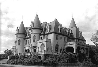
The Northfield Chateau, also variously known as Chalet Schell and Birnam House, was a large mansion on Highland Avenue in Northfield, Massachusetts. It no longer exists.

Maryland Route 350 is a state highway in the U.S. state of Maryland. Known as Mount Hermon Road, the state highway runs 11.80 miles (18.99 km) from Main Street in Salisbury east to MD 354 in Powellville. MD 350 provides access to a large area of farmland and forest in southeastern Wicomico County as well as Salisbury–Ocean City–Wicomico Regional Airport. The state highway was constructed from Salisbury to Mount Hermon in the 1910s and from Mount Hermon to Powellville in the first half of the 1930s.
Mount Hermon is a high mountain on the border between Syria and Lebanon. The name may also refer to:
Mount Hermon is an unincorporated community in Alamance County, North Carolina, United States. The community is centered between North Carolina Highway 87, and North Carolina Highway 49, in south-central Alamance County.

Mount Hermon is a township in Pasquotank County, North Carolina. Bordering Nixonton, Providence, Elizabeth City, and Perquimans County, this township has an area of 34.7 square miles and a population of 4,206.
Mount Hermon is a census-designated place (CDP) in Pittsylvania County, Virginia, United States. The population as of the 2010 Census was 3,966.
Mount Hermon is an unincorporated community and census-designated place (CDP) located within Hope Township in Warren County, in the U.S. state of New Jersey, that was defined as part of the 2010 United States Census. As of the 2010 Census, the CDP's population was 141.

Kentucky Route 63 (KY 63) is a north–south state highway that traverses Monroe and Barren counties in south central Kentucky.


