The Alexandra Mountains are a group of low, separated mountains in the north portion of Edward VII Peninsula, just southwest of Sulzberger Bay in Marie Byrd Land, Antarctica.

Marie Byrd Land (MBL) is an unclaimed region of Antarctica. With an area of 1,610,000 km2 (620,000 sq mi), it is the largest unclaimed territory on Earth. It was named after the wife of American naval officer Richard E. Byrd, who explored the region in the early 20th century.
The Haines Mountains are a range of ice-capped mountains trending northwest–southeast for about 25 nautical miles and forming the southwest wall of Hammond Glacier, in the Ford Ranges of Marie Byrd Land, Antarctica.

The Executive Committee Range is a mountain range consisting of five major volcanoes, which trends north-south for 80 km (50 mi) along the 126th meridian west, in Marie Byrd Land, Antarctica.

The Fosdick Mountains are an east–west trending mountain range with marked serrate outlines, standing along the south side of Balchen Glacier at the head of Block Bay, in the Ford Ranges of Marie Byrd Land, Antarctica.
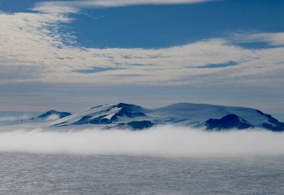
The Ford Ranges are a collection of mountain groups and ranges standing east of Sulzberger Ice Shelf and Block Bay in the northwest part of Marie Byrd Land, Antarctica.
The Mackay Mountains are a prominent group of peaks 10 nautical miles south of the Allegheny Mountains in the Ford Ranges of Marie Byrd Land, Antarctica.
Sulzberger Ice Shelf is an ice shelf about 85 nautical miles long and 50 nautical miles wide bordering the coast of Marie Byrd Land between Edward VII Peninsula and Guest Peninsula in Antarctica.
The Guest Peninsula is a snow-covered peninsula about 45 nautical miles long between the Sulzberger Ice Shelf and Block Bay, in the northwest part of Marie Byrd Land, Antarctica.

The Billboard is a massive granite monolith in the Sarnoff Mountains of the Ford Ranges of Marie Byrd Land, West Antarctica, standing just west of Mount Rea between Arthur Glacier and Boyd Glacier. It was discovered in November 1934 by a Second Byrd Antarctic Expedition (1933–35) sledge party under Paul Siple, and is so named because of its form and appearance with vertical faces rising above the continental ice.
Hershey Ridge is a low, ice-covered ridge trending in a northwest–southeast direction for about 30 nautical miles between McKinley Peak and the Haines Mountains, in the Ford Ranges of Marie Byrd Land, Antarctica.
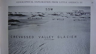
Mount Gilmour is a mountain 4 nautical miles (7 km) southeast of Mount Passel on the central part of the irregular ridge separating Crevasse Valley Glacier and Arthur Davis Glacier, in the Edsel Ford Ranges of Marie Byrd Land, Antarctica.
Block Bay is a long ice-filled bay lying east of Guest Peninsula along the coast of Marie Byrd Land, Antarctica.
The Denfeld Mountains are a group of scattered mountains between Crevasse Valley Glacier and Arthur Glacier in the Ford Ranges of Marie Byrd Land, Antarctica.
The Phillips Mountains are a range of mountains on the north side of Balchen Glacier and Block Bay in the Ford Ranges, Marie Byrd Land, Antarctica.
Sarnoff Mountains is a range of mountains, 251 nautical miles long and 4 to 8 nautical miles wide separating the west-flowing Boyd Glacier and Arthur Glacier in the Ford Ranges of Marie Byrd Land, Antarctica.
Thompson Ridge is a rock ridge, 2 nautical miles (3.7 km) long and trending north–south on the south shore of Block Bay, 2.1 nautical miles (3.5 km) northwest of Mount Luyendyk, Fosdick Mountains in Marie Byrd Land, Antarctica. It is composed wholly of Fosdick Metamorphic Rocks. These are determined to be of Cretaceous age.

Warpasgiljo Glacier is a valley glacier about 25 mi (40 km) long, flowing West to Sulzberger Ice Shelf between the Swanson Mountains on the North and Mounts Rea and Cooper on the South, in the Edsel Ford Ranges of Marie Byrd Land. This glacier was discovered by and named for the four Geological Party Expedition members of the West Base of the United States Antarctic Service (USAS), in aerial flights and from ground surveys in November–December 1940, as part of the Antarctic Expedition of 1939-1941 led by Rear Admiral Richard E. Byrd.

Mount Luyendyk is a summit in the western Fosdick Mountains of the Ford Ranges of Marie Byrd Land, West Antarctica. It forms a prominent exposure in the northwestern Iphigene massif. The peak is named in recognition of Bruce P. Luyendyk, professor (emeritus), University of California, Santa Barbara, who was active in ground- and ocean-based Antarctic research from 1989 to 2015, significantly advancing the scientific knowledge of the Ross Embayment region of Antarctica. Luyendyk led two on-land expeditions in the Ford Ranges, and was principal investigator for five marine geophysical expeditions in the Ross Sea.

Bruce Peter Luyendyk is an American geophysicist and oceanographer, currently professor emeritus of marine geophysics at the University of California, Santa Barbara. His work spans marine geology of the major ocean basins, the tectonics of southern California, marine hydrocarbon seeps, and the tectonics and paleoclimate of Antarctica. His research includes tectonic rotations of the California Transverse Ranges, participation in the discovery of deep-sea hydrothermal vents, quantitative studies of marine hydrocarbon seeps, and geologic exploration of the Ford Ranges in Marie Byrd Land, Antarctica.
