
Joinville Island is the largest island of the Joinville Island group, about 40 nautical miles long in an east–west direction and 12 nautical miles wide, lying off the northeastern tip of the Antarctic Peninsula, from which it is separated by the Antarctic Sound.

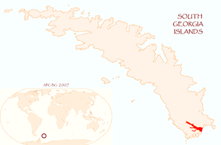
King Edward Cove is a sheltered cove in the west side of Cumberland East Bay, South Georgia. This cove and its surrounding features, frequented by early sealers at South Georgia, was charted by the Swedish Antarctic Expedition, 1901–04, under Otto Nordenskiöld who named it Grytviken. That name, meaning 'Pot Bay,' was subsequently assumed by the whaling station and settlement built in 1904. The cove got its present name in about 1906 for King Edward VII of the United Kingdom.

Antarctic Bay is a bay 1 mile (1.6 km) wide which recedes southwest 4 miles (6 km), entered between Antarctic Point and Morse Point on the north coast of South Georgia. It was probably first sighted by a British expedition under James Cook in 1775, and was explored in 1902 by members of the Swedish Antarctic Expedition, under Otto Nordenskiöld, who named it for their ship, the Antarctic. An alternative (defunct) name for it was Woodward Harbour.
Drygalski Fjord is a bay 1 mile (1.6 km) wide which recedes northwestwards 7 miles (11 km), entered immediately north of Nattriss Head along the southeast coast of South Georgia. It was charted by the Second German Antarctic Expedition, 1911–12, under Wilhelm Filchner, and named for Professor Erich von Drygalski, the leader of the First German Antarctica Expedition, 1901–03.
Novosilski Glacier is a glacier, 8 miles (13 km) long and 2 miles (3.2 km) wide, flowing in a westerly direction from the southwest slopes of the Salvesen Range to Novosilski Bay on the south coast of South Georgia. First surveyed and named by a German expedition 1928–29, under Kohl-Larsen. The name derives from nearby Novosilski Bay.
Hindle Glacier is a glacier 6 miles (10 km) long, flowing north from the vicinity of Mount Paterson into Royal Bay on the north coast of South Georgia. It was surveyed by the South Georgia Survey (SGS), 1951–52. The name "Bruce Glacier" was used unofficially by the British South Georgia Expedition, 1954–55, but a number of Antarctic features are named for Dr. William S. Bruce. The UK Antarctic Place-Names Committee recommended in 1957 that the glacier be named for Dr. Edward Hindle, a British zoologist who, as Honorary Secretary of the Royal Geographical Society, was of great assistance to the SGS expeditions.
Paget Glacier is a glacier in South Georgia, 4 miles (6 km) long and 1 mile (1.6 km) wide, which flows northeast from the north slopes of Mount Paget into the west side of Nordenskjold Glacier. The glacier was roughly surveyed in 1928–29 by a German expedition under Kohl-Larsen, and resurveyed in 1951–52 by the SGS. The name, which is derived from nearby Mount Paget, was given by the SGS in 1951–52.
Mount Worsley is a mountain, 1,105 m, on the west side of Briggs Glacier in South Georgia. It was surveyed by the South Georgia Survey in the period 1951–57, and named by the United Kingdom Antarctic Place-Names Committee (UK-APC) for Frank Arthur Worsley (1872–1943), skipper of the Endurance on 1914-16 Imperial Trans-Antarctic Expedition. Worsley accompanied Ernest Shackleton in the James Caird from Elephant Island to King Haakon Bay, South Georgia, and made the overland crossing with him to Stromness whaling station.

Larsen Harbour is a narrow 2.6 miles (4.2 km) long inlet of indenting volcanic rocks and sheeted dykes known as the Larsen Harbour Formation. It is a branch of Drygalski Fjord, entered 2.5 miles (4 km) west-northwest of Nattriss Head, at the southeast end of South Georgia Island. It was charted by the Second German Antarctic Expedition, 1911–12, under Filchner, who named it for Captain Carl Anton Larsen a Norwegian explorer, who made significant contributions to the exploration of Antarctica. The most significant of these was the first discovery of fossils on the continent, for which he received the Back Grant from the Royal Geographical Society. Larsen is also considered the founder of the Antarctic whaling industry and the settlement and whaling station of Grytviken, South Georgia.

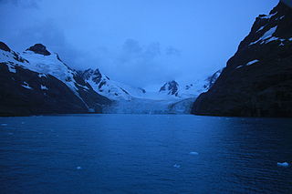
Hamberg Glacier is a glacier which flows in an east-northeasterly direction from the northeast side of Mount Sugartop to the west side of the head of Moraine Fjord, South Georgia. It was charted by the Swedish Antarctic Expedition, 1901–04, under Otto Nordenskiöld, who named it for Axel Hamberg, a Swedish geographer, mineralogist and Arctic explorer.
Heaney Glacier is a glacier, 4 nautical miles (7 km) long, which lies close northwest of Cook Glacier and flows northeast and then east toward Saint Andrews Bay on the north coast of South Georgia. It was surveyed by the South Georgia Survey, 1951–52, and named by the UK Antarctic Place-Names Committee for John B. Heaney, a surveyor with that expedition.
Philippi Glacier is a glacier flowing east into Brandt Cove on the southwest side of Drygalski Fjord, at the southeast end of South Georgia. Charted by the German Antarctic Expedition, 1911–12, under Wilhelm Filchner, who named it for Emil Philippi, glaciologist with the German Antarctic Expedition, 1901–03, under Erich von Drygalski, and professor of geology at the University of Jena.
Risting Glacier is a glacier, 4.5 nautical miles (8 km) long, lying north of Jenkins Glacier and flowing southeast into the head of Drygalski Fjord in the south part of South Georgia. Surveyed by the South Georgia Survey (SGS) under Duncan Carse in the period 1951–57, and named by the United Kingdom Antarctic Place-Names Committee (UK-APC) for Sigurd Risting (1870-1935), Norwegian whaling historian; secretary of Norsk Hvalfangerforening, 1918–35, and editor of Norsk Hvalfangst-Tidende, 1922–35. The German Antarctic Expedition under Wilhelm Filchner, 1911–12, named Drygalski Fjord and this glacier for Erich von Drygalski, leader of the German Antarctic Expedition, 1901–03, but the name for the glacier did not survive. A number of features in Antarctica, including Drygalski Glacier, are named for Drygalski.
Mount Back is a peak, 650 metres (2,130 ft) high, located 1.5 nautical miles (3 km) south of Doris Bay, South Georgia. It was named by the UK Antarctic Place-Names Committee for Squadron Leader Anthony H. Back, Royal Air Force, assistant surveyor with the British Combined Services Expedition of 1964–65, who assisted in the survey of this peak.
Coffin Top is a mountain with a flattened summit, 745 metres (2,440 ft) high, located 1.4 nautical miles (2.6 km) east-northeast of Mount Fagan and 1.6 nautical miles (3 km) northwest of Moltke Harbour, South Georgia. The feature was named "Sarg-Berg" by the German group of the International Polar Year Expedition, 1882–83. An English form of the name, Coffin Top, was recommended by UK Antarctic Place-Names Committee in 1954.
Sutton Crag is a crag, 1,490 metres (4,890 ft), standing north of and connected by a long ridge to the west peak of Mount Paget in the Allardyce Range of South Georgia. Charted and unofficially named Sentinel or Sentinel Peak by the British South Georgia Expedition, 1954–55. To avoid duplication with other "sentinel" names, the United Kingdom Antarctic Place-Names Committee (UK-APC) in 1957 named this feature for George A. Sutton, leader of the expedition, who reached the summit in 1954.
Douglas Crag is a crag, 1,670 metres (5,480 ft) high, standing 1 nautical mile (2 km) southeast of Mount Macklin at the south end of the Salvesen Range of South Georgia. It was surveyed by the South Georgia Survey in the period 1951–57, and named by the UK Antarctic Place-Names Committee for George V. Douglas, a geologist with the British expedition under Ernest Shackleton, 1921–22.
Mount Fagan is a mountain rising to 930 metres (3,050 ft) 1.4 nautical miles (2.6 km) west-southwest of Coffin Top and 2.75 nautical miles (5.1 km) west of Moltke Harbour, South Georgia. It was named by the UK Antarctic Place-Names Committee in 1971 for Captain P.F. Fagan, Royal Engineers, surveyor on the British Combined Services Expedition of 1964–65, and the first person to climb the mountain.
McIlroy Peak is a peak rising to 745 metres (2,440 ft) west of Husvik Harbour and 0.8 nautical miles (1.5 km) south of Mount Barren, South Georgia. It was named by the UK Antarctic Place-Names Committee in 1990 after Dr. James A. McIlroy, surgeon on the British Imperial Trans-Antarctic Expedition, 1914–16, in the Endurance, and on the Shackleton–Rowett Expedition, 1921–22, in the Quest.
Mount Macklin is a mountain having 2 peaks, the higher at 1,900 metres (6,200 ft), between Mount Carse and Douglas Crag in the southern part of the Salvesen Range of South Georgia. It was surveyed by the South Georgia Survey in the period 1951–57, and was named by the UK Antarctic Place-Names Committee for Alexander H. Macklin, the medical officer of the Imperial Trans-Antarctic Expedition under Ernest Shackleton, 1914–16. Macklin accompanied Shackleton in the voyage of the James Caird from Elephant Island to King Haakon Bay, South Georgia.