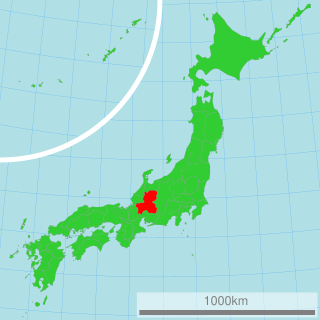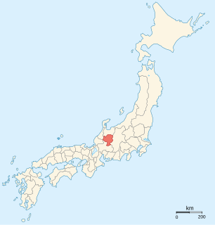
Hida Province was a province of Japan in the area that is today the northern portion of Gifu Prefecture in the Chūbu region of Japan. Hida bordered on Echizen, Mino, Shinano, Etchū, and Kaga Provinces. It was part of Tōsandō Circuit. Its abbreviated form name was Hishū (飛州). Under the Engishiki classification system, Hida was ranked as a "inferior country" (下国) and a middle country (中国) in terms of its importance and distance from the capital. Currently, the entire area of the former Hida Province consists of the cities of Hida, Takayama and most of the city of Gero, and the village of Shirakawa, in Ōno District.
Akaishi Mountains is a mountain range in central Honshū, Japan, bordering Nagano, Yamanashi and Shizuoka prefectures. It is also called the Southern Alps, as it joins with the Hida Mountains and the Kiso Mountains to form the Japanese Alps.

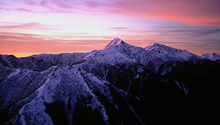
The Hida Mountains, or Northern Alps, is a Japanese mountain range which stretches through Nagano, Toyama and Gifu prefectures. A small portion of the mountains also reach into Niigata Prefecture. William Gowland coined the phrase "Japanese Alps" during his time in Japan, but he was only referring to the Hida Mountains when he used that name. The Kiso and Akaishi mountains received the name in the ensuing years.

Hida is a city located in Gifu, Japan. As of 1 December 2017, the city had an estimated population of 24,726, and a population density of 31 persons per km2, in 8,905 households. The total area of the city was 792.53 square kilometres (306.00 sq mi). The official kanji for the city is actually 飛驒, which uses the old (kyūjitai) rendering of the 騨 character. However, the 驒 character is not included on the official list of usable characters, so the 騨 character is often used outside of the city.
Shirakawa is a village located in Ōno District, Gifu Prefecture, Japan. It is best known for being the site of Shirakawa-gō, a small, traditional village showcasing a building style known as gasshō-zukuri. Together with Gokayama in Nanto, Toyama, it is one of UNESCO's World Heritage Sites.

The Kurobe River is a river in Toyama Prefecture, Japan. 86 kilometres (53 mi) in length, it has a watershed of 689 km².
The Dragu is a tributary of the river Almaș in Romania. It flows into the Almaș in Hida.

The Hida River has its source in Mount Norikura in Takayama, Gifu Prefecture, Japan. It flows from the northern to the southern section of the prefecture before emptying into the Kiso River in Minokamo.
Mount Yake literally, "Burning mountain" is an active volcano in the Hida Mountains, lying between Matsumoto, Nagano Prefecture, and Takayama, Gifu Prefecture, Japan. It is one of the 100 Famous Japanese Mountains, reaching 2,455 m (8,054 ft) at the highest peak.

Hida-Osaka Station is a railway station on the Takayama Main Line in the city of Gero, Gifu Prefecture, Japan, operated by Central Japan Railway Company.
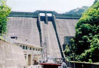
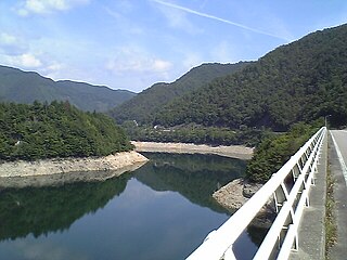
Asahi Dam (朝日ダム) is a dam built on the class 1 Hida River, located in the city of Takayama, Gifu Prefecture, Japan.

The river Chibit is in the Altai Republic, Russia. It is the right arm of the Chuya River.
The Maze River is a river in Japan which originates in Takayama, Gifu. It flows through Gero before emptying into the Hida River. Due to its clear waters, it is home to the Japanese giant salamander.

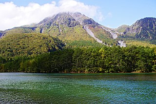
Mount Norikura is a potentially active volcano located on the borders of Gifu and Nagano prefectures in Japan. It is part of the Hida Mountains and is listed among the 100 Famous Japanese Mountains and the New 100 Famous Japanese Mountains.

The Hida-Kisogawa Quasi-National Park is a quasi-national park in Japan. The park covers the Hida River from Gero to Minokamo in Gifu Prefecture; it also covers the middle reaches of the Kiso River from Mizunami, Gifu Prefecture, to Inuyama, Aichi Prefecture. It was designated a quasi-national park in March 1964.

Mount Kasa is one of the 100 Famous Japanese Mountains, reaching the height of 2,897 m (9,505 ft). It is situated in Japan's Hida Mountains in Gifu Prefecture and in Chūbu-Sangaku National Park. The shape of the mountain looks like the Umbrella("Kasa"-笠) in the triangle. Therefore, it became this name. There are many mountains with same name in Japan and this is the tallest.

Mount Jōnen is one of the 100 Famous Japanese Mountains, reaching the height of 2,857 m (9,373 ft). It is situated in Japan's Hida Mountains in Nagano Prefecture and in Chūbu-Sangaku National Park. The shape of the mountain looks like the triangle. It can be seen from Azumi Basin.

Mount Kurobegorō is one of the 100 Famous Japanese Mountains, reaching the height of 2,839.58 m (9,316 ft). It is situated in Japan's Hida Mountains in Gifu Prefecture and Toyama Prefecture. It was specified for Chūbu-Sangaku National Park on December 4, 1934.
Events in the year 1968 in Japan.