The Larsen Islands are a small group of islands north-west of Moreton Point, the western extremity of Coronation Island, in the South Orkney Islands of Antarctica. They were discovered by Captains George Powell and Nathaniel Palmer on the occasion of their joint cruise in December 1821. The islands were named on Petter Sørlle's chart, based upon his survey of the South Orkney Islands in 1912–1913, in honour of Carl Anton Larsen.
The Trojan Range is a mountain range rising to 2,760 metres (9,055 ft), extending northward from Mount Francais along the east side of Iliad Glacier, Anvers Island, in the Palmer Archipelago of the British Antarctic Territory. It was surveyed by the Falkland Islands Dependencies Survey (FIDS) in 1955 and named by the UK Antarctic Place-Names Committee (UK-APC) for the Trojans, one of the opposing sides in the Trojan War in Homer's Iliad.
White Island is an island in the Ross Archipelago of Antarctica. It is 15 nautical miles long, protruding through the Ross Ice Shelf immediately east of Black Island. It was discovered by the British National Antarctic Expedition (1901–04) and so named by them because of the mantle of snow that covers it.

Jason Peninsula is a large peninsula on the east coast of Graham Land comprising several mainly snow-covered summits. It rises above the Larsen Ice Shelf and extends from the narrow neck of land east of Medea Dome for 42 nautical miles (78 km), terminating in Cape Framnes. This feature was first seen from seaward on December 1, 1893, by Carl Anton Larsen, who named one of the high peaks "Mount Jason" after his ship, the Jason. Larsen was too distant to map the area in detail, but in 1902 the Swedish Antarctic Expedition under Otto Nordenskiöld observed the area from Borchgrevink Nunatak and reported the peaks seen by Larsen to be separated from the mainland. The name "Jason Island" was subsequently used for Larsen's discovery, but in 1955 the Falkland Islands Dependencies Survey determined this feature to be a large peninsula.

Quito Glacier is a glacier draining the northeast slopes of Mount Plymouth and flowing northeastwards into the sea west of Canto Point in north Greenwich Island, South Shetland Islands. It was named after the capital of Ecuador, c. 1990, by the Ecuadorian Antarctic Expedition.

Black Island, is an island in the Ross Archipelago, 12 nautical miles long, projecting through the Ross Ice Shelf to a height of 1,040 metres (3,410 ft).meters. It was discovered by the British National Antarctic Expedition and named by them for its appearance. The island is largely ice free and principally composed of black volcanic rock. The island's northernmost point is named Cape Hodgson, commemorating Thomas Vere Hodgson, one of the oldest members of the Discovery Expedition.

Cumberland West Bay is a bay forming the western arm of Cumberland Bay, South Georgia. It is entered southward of Larsen Point, where it is 2.5 miles (4 km) wide and extends 7 miles (11 km) in a southwest direction. It is separated from Cumberland East Bay by Thatcher Peninsula. Papua Beach is situated on its southeast shore.
Drygalski Fjord is a bay 1 mile (1.6 km) wide which recedes northwestwards 7 miles (11 km), entered immediately north of Nattriss Head along the southeast coast of South Georgia. It was charted by the Second German Antarctic Expedition, 1911–12, under Wilhelm Filchner, and named for Professor Erich von Drygalski, the leader of the First German Antarctica Expedition, 1901–03.

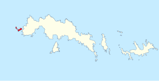
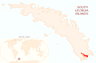
Larsen Harbour is a narrow 2.6 miles (4.2 km) long inlet of indenting volcanic rocks and sheeted dykes known as the Larsen Harbour Formation. It is a branch of Drygalski Fjord, entered 2.5 miles (4 km) west-northwest of Nattriss Head, at the southeast end of South Georgia Island. It was charted by the Second German Antarctic Expedition, 1911–12, under Filchner, who named it for Captain Carl Anton Larsen a Norwegian explorer, who made significant contributions to the exploration of Antarctica. The most significant of these was the first discovery of fossils on the continent, for which he received the Back Grant from the Royal Geographical Society. Larsen is also considered the founder of the Antarctic whaling industry and the settlement and whaling station of Grytviken, South Georgia.
William Glacier is a glacier flowing south from the interior highlands of Anvers Island to the head of Börgen Bay on the southeast coast of the island, in the Palmer Archipelago. Discovered by the Belgian Antarctic Expedition, 1897–99, under Gerlache, and charted by them simply as a "grand glacier." The name William Glacier first appears on a chart based upon a 1927 survey by DI personnel on the Discovery. Gateway Ridge separates William Glacier from Hooper Glacier.

Brown Peninsula is a nearly ice-free peninsula, 10 nautical miles long and 4 nautical miles wide, which rises above the Ross Ice Shelf northward of Mount Discovery, to which it is connected by a low isthmus. It was discovered by the British National Antarctic Expedition, 1901–04 (BrNAE), which named it "Brown Island" because of its color and its island-like character. Since it is a peninsula, the name has been altered accordingly.
Douglas Strait is a strait 2 nautical miles (4 km) wide between Thule Island and Cook Island, in the South Sandwich Islands. The existence of this strait was first noted by a Russian expedition under Fabian Gottlieb von Bellingshausen in 1820. It was charted in 1930 by Discovery Investigations personnel on the Discovery II and named for Vice-Admiral Sir Percy Douglas, a member of the Discovery Committee.
Cape Flannery is a cape which forms the west end of Thule Island in the South Sandwich Islands. It was charted in 1930 by Discovery Investigations personnel on the RSS Discovery II, who named it for Sir Fortescue Flannery, a member of the Discovery Committee.

Moreton Point is a point 1 nautical mile (2 km) north of Return Point at the western end of Coronation Island, in the South Orkney Islands off Antarctica. It was roughly charted by Captains George Powell and Nathaniel Palmer in 1821, and was named by Discovery Investigations personnel on the Discovery II who charted the islands in 1933.
Mount Harmer is an ice-covered peak, 1,115 metres (3,660 ft) high, in the north-central portion of Cook Island, in the South Sandwich Islands. It was charted in 1930 by Discovery Investigations personnel on the Discovery II, who named it for Sir Sidney F. Harmer, Vice-Chairman of the Discovery Committee.
The Haslam Heights are a line of peaks trending north-northeast–south-southwest, rising to about 1,000 metres (3,300 ft) to the west of Vallot Glacier and Nye Glacier in Arrowsmith Peninsula, Graham Land, Antarctica. They were probably first seen by the French Antarctic Expedition, 1908–10 under Jean-Baptiste Charcot, which roughly charted the area in 1909. They were roughly mapped by the Falkland Islands Dependencies Survey (FIDS) in 1948, and named in 1985 by the UK Antarctic Place-Names Committee (UK-APC) after Rear Admiral Sir David W. Haslam, Hydrographer of the Navy, 1975–85.
Vallot Glacier is a glacier flowing northwest to Laubeuf Fjord close south of Lewis Peaks, on Arrowsmith Peninsula in Graham Land. It was mapped by the Falkland Islands Dependencies Survey (FIDS) from surveys and air photos, 1948–59, and was named by the United Kingdom Antarctic Place-Names Committee (UK-APC) for Joseph Vallot, a French naturalist and glaciologist who first measured the surface velocity of a glacier over a long period, in Switzerland, 1891–99.
Lincoln Nunatak is a snow-capped nunatak with a rocky west face, at the end of a ridge running westward from Mount Mangin on Adelaide Island, Antarctica. It was named by the UK Antarctic Place-Names Committee for Flight Lieutenant Warren D. Lincoln, Royal Air Force, a pilot with the British Antarctic Survey Aviation Unit based at Adelaide Station in 1962–63.
