The Victory Mountains is a major group of mountains in Victoria Land, Antarctica, about 100 nautical miles long and 50 nautical miles wide, which is bounded primarily by Mariner and Tucker glaciers and the Ross Sea. They are north of the Mountaineer Range, east of the Freyberg Mountains and south of the Concord Mountains and the Admiralty Mountains. The division between the Victory Mountains and the Concord Mountains is not precise but apparently lies in the vicinity of Thomson Peak.
Belgica Mountains is an isolated chain of mountains about 10 miles (16 km) long, standing 60 miles (97 km) east-southeast of the Sor Rondane Mountains in Queen Maud Land, in the Antarctic. The chain was discovered by the Belgian Antarctic Expedition (1957-1958) under Gaston de Gerlache, and named after the ship Belgica, commanded by his father, Lt. Adrien de Gerlache, leader of the Belgian Antarctic Expedition of 1897–99.

The Prince Charles Mountains are a major group of mountains in Mac. Robertson Land in Antarctica, including the Athos Range, the Porthos Range, and the Aramis Range. The highest peak is Mount Menzies, with a height of 3,228 m (10,591 ft). Other prominent peaks are Mount Izabelle and Mount Stinear. These mountains, together with other scattered peaks, form an arc about 420 km (260 mi) long, extending from the vicinity of Mount Starlight in the north to Goodspeed Nunataks in the south.
The Trojan Range is a mountain range rising to 2,760 metres (9,055 ft), extending northward from Mount Francais along the east side of Iliad Glacier, Anvers Island, in the Palmer Archipelago of the British Antarctic Territory. It was surveyed by the Falkland Islands Dependencies Survey (FIDS) in 1955 and named by the UK Antarctic Place-Names Committee (UK-APC) for the Trojans, one of the opposing sides in the Trojan War in Homer's Iliad.
The Scott Mountains are a large number of isolated peaks lying south of Amundsen Bay in Enderby Land of East Antarctica, Antarctica. Discovered on 13 January 1930 by the British Australian New Zealand Antarctic Research Expedition (BANZARE) under Sir Douglas Mawson. He named the feature Scott Range after Captain Robert Falcon Scott, Royal Navy. The term mountains is considered more appropriate because of the isolation of its individual features.
The Sør Rondane Mountains are a group of mountains about 100 miles (160 km) long with main peaks rising to 3400 m, between the Queen Fabiola Mountains and Wohlthat Mountains in Queen Maud Land. They were discovered and photographed from the air by members of the Lars Christensen Expedition (LCE) on February 6, 1937, and named after Rondane, a mountain massif in southern Norway. The mountains and their constituent features were mapped in greater detail and named in 1957 by Norwegian cartographers working with air photos taken by U.S. Navy Operation Highjump, 1946–47.

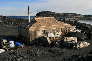
Cape Royds is a dark rock cape forming the western extremity of Ross Island, facing on McMurdo Sound, Antarctica. It was discovered by the British National Antarctic Expedition (BrNAE) (1901–1904) and named for Lieutenant Charles Royds, Royal Navy, who acted as meteorologist on the expedition. Royds subsequently rose to become an Admiral and was later Commissioner of the Metropolitan Police, London. The cape is the site of Shackleton's Hut, the expedition camp of the British Antarctic Expedition, 1907–09.
The Porthos Range is the second range south in the Prince Charles Mountains of Antarctica, extending for about 30 miles in an east-to-west direction between Scylla Glacier and Charybdis Glacier. First visited in December 1956 by the Australian National Antarctic Research Expeditions (ANARE) southern party under W.G. Bewsher (1956-57) and named after Porthos, a character in Alexandre Dumas, père's novel The Three Musketeers, the most popular book read on the southern journey.

Wright Upper Glacier is an ice apron at the upper west end of Wright Valley in the Asgard Range, Antarctica. It is formed by a glacier flowing east from the inland ice plateau. It was named by the Victoria University of Wellington Antarctic Expedition (VUWAE) (1958–59) for C. S. Wright, a member of the British Antarctic Expedition (1910–13), after whom the "Wright Glacier" was named.

The Gruber Mountains are a small group of mountains consisting of a main massif and several rocky outliers, forming the northeast portion of the Wohlthat Mountains in Queen Maud Land, Antarctica. They were discovered and plotted from air photos by the Third German Antarctic Expedition (GerAE), 1938–39, under Alfred Ritscher. The mountains were remapped by the Sixth Norwegian Antarctic Expedition, 1956–60, who named them for Otto von Gruber, the German cartographer who compiled maps of this area from air photos taken by the GerAE. This feature is not to be confused with "Gruber-Berge," an unidentified toponym applied by the GerAE in northern the Mühlig-Hofmann Mountains.
Mount Dewar is a mountain rising to about 1,600 metres (5,200 ft) to the southwest of Aronson Corner in the Pioneers Escarpment, Shackleton Range. It was photographed from the air by the U.S. Navy in 1967 and surveyed by the British Antarctic Survey from 1968 to 1971. In association with the names of pioneers of polar life and travel grouped in this area, it was named in 1971 by the UK Antarctic Place-Names Committee after Sir James Dewar, a Scottish chemist and physicist who invented the thermos flask about 1892.
Mount Grytøyr is a broad ice-topped mountain, 2,695 metres (8,840 ft) high, between Flogeken Glacier and Stuttflog Glacier in the Mühlig-Hofmann Mountains of Queen Maud Land, Antarctica. It was mapped by Norwegian cartographers from surveys and air photos by the Sixth Norwegian Antarctic Expedition (1956–60) and named for B. Grytøyr, a meteorologist with the expedition (1956–58).

Giaever Glacier is a glacier flowing northwest between Mount Kerckhove de Denterghem and Mount Lahaye in the Belgica Mountains of Antarctica. It was discovered by the Belgian Antarctic Expedition, 1957–58, under Gaston de Gerlache, who named it for Norwegian explorer John Schjelderup Giæver, counselor for the expedition, and leader of the Norwegian–British–Swedish Antarctic Expedition, 1949–52.
Gluvrekletten Peak is a peak, 2,200 metres (7,200 ft) high, between Terningskarvet Mountain and Nupskammen Ridge in the Gjelsvik Mountains of Queen Maud Land, Antarctica. It was photographed from the air by the Third German Antarctic Expedition (1938–39). It was mapped by Norwegian cartographers from surveys and air photos by the Norwegian–British–Swedish Antarctic Expedition (1949–52) and the Norwegian expedition (1958–59) and named Gluvrekletten.
Mount Hampson is a mountain 1 nautical mile (2 km) north of Mount Rhodes, in the northern part of the Tula Mountains in Enderby Land, Antarctica. It was plotted from air photos taken from Australian National Antarctic Research Expeditions aircraft in 1956, and was named by the Antarctic Names Committee of Australia for R.V. Hampson, a member of the crew of the Discovery during the British Australian New Zealand Antarctic Research Expedition of 1929–31.
The Hamrane Heights are ice-free heights between Skarsdalen Valley and Hei Glacier in the Sverdrup Mountains of Queen Maud Land, Antarctica. They were photographed from the air by the Third German Antarctic Expedition (1938–39). The heights were mapped by Norwegian cartographers from surveys and air photos by Norwegian–British–Swedish Antarctic Expedition (1949–52) and from air photos by the Norwegian expedition (1958–59) and named Hamrane.
Mount Harding is the largest mountain in the Grove Mountains of Antarctica, in the south-central part of the range and about 4 nautical miles (7 km) west of Gale Escarpment. It was mapped by the Australian National Antarctic Research Expeditions (1956–60) from aerial photographs, and was named by the Antarctic Names Committee of Australia for N.E. Harding, a topographic draftsman with the Division of National Mapping, Australian Department of National Development, who contributed substantially to the production of Antarctic maps.
Mount Lorette is an ice-free mountain resembling a cathedral in form, rising to 2,200 metres (7,200 ft) close west of Mount Loodts in the Belgica Mountains of Antarctica. It was discovered by the Belgian Antarctic Expedition, 1957–58, under G. de Gerlache, who named it for Notre Dame de Lorette, a patron saint of aviators.
Mount Maere is a mountain, 2,300 metres (7,500 ft) high, on the west side of Norsk Polarinstitutt Glacier immediately southwest of Mount Bastin, in the Belgica Mountains of Antarctica. It was discovered by the Belgian Antarctic Expedition, 1957–58, under G. de Gerlache, who named it for Xavier de Maere d'Aertrijcke, second-in-command and chief meteorologist of the expedition.


