Mount Ng'iro

Last updated
Mount Ngiro
Kenya relief location map.jpg
Red triangle with thick white border.svg
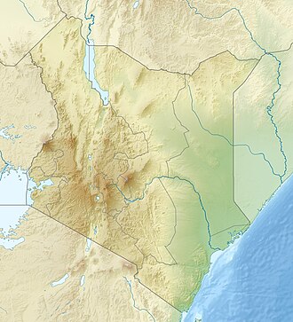
Mount Ngiro
Location in Kenya
Highest point
Elevation 2,848 m (9,344 ft) [1] [2]
Prominence 1,501 m (4,925 ft) [1]
Listing Ultra
Coordinates 02°11′30″N36°48′57″E / 2.19167°N 36.81583°E / 2.19167; 36.81583 [1]
Geography
Location Kenya
Parent range Nyiru Range

Mount Ng'iro, also known as Mount Nyiru or Mount Nyiro, is a mountain in the north of Kenya overlooking the Suguta Valley, part of the Great Rift Valley, to the west. The mountain is surrounded by desert, but is forested on its upper slopes. [3] It lies in the territory of the Samburu people. Some subclans under the Lmasula phratry cultivate bees on the mountain, and as bee-keepers claim exclusive rights to the land and water. [4]

Contents

There are 78.9 square kilometres of montane forest on the mountain. African juniper ( Juniperus procera ) is the predominant tree at lower elevations and in drier areas, growing in pure stands or with Myrsine africana . Faurea saligna and Ilex mitis are the predominant trees in more humid high-elevation areas. In high-elevation areas with the most condensing mist the bamboo Oldeania alpina forms dense thickets 6 to 8 meters tall. Lasiosiphon glaucus is the dominant tree in summit forests, forming close stands up to 8 meters tall. There are grassy clearings around the summit, maintained by regular burning and heavy livestock grazing by Samburu pastoralists. The clearings are interspersed with thickets of Hypericum revolutum and young junipers. [5] [6]

The Nyiro shrew ( Crocidura macowi ) and Mount Nyiro bearded chameleon ( Kinyongia asheorum ) are endemic to the mountain.

Mount Nyiru Forest Reserve was established in 1956, and covers an area of 454.96 km2. [7]

See also

Related Research Articles

<span class="mw-page-title-main">Mount Kenya</span> Highest mountain in Kenya

Mount Kenya is an extinct volcano in Kenya and the second-highest peak in Africa, after Kilimanjaro. The highest peaks of the mountain are Batian, Nelion and Point Lenana. Mount Kenya is located in the former Eastern and Central provinces of Kenya; its peak is now the intersection of Meru, Embu, Kirinyaga, Nyeri and Tharaka Nithi counties, about 16.5 kilometres south of the equator, around 150 km (90 mi) north-northeast of the capital Nairobi. Mount Kenya is the source of the name of the Republic of Kenya.

<span class="mw-page-title-main">Mount Bartle Frere</span> Mountain in Queensland, Australia

Mount Bartle Frere is the highest mountain in Queensland at an elevation of 1,611 metres (5,285 ft). The mountain was named after Sir Henry Bartle Frere, a British colonial administrator and then president of the Royal Geographical Society by George Elphinstone Dalrymple in 1873. Bartle Frere was British Governor of Cape Colony at the outset of the Anglo-Zulu War.

<span class="mw-page-title-main">Samburu National Reserve</span> Game reserve in Kenya

Samburu National Reserve is a game reserve on the banks of the Ewaso Ng'iro river in Kenya. It is 165 km2 (64 sq mi) in size and is 350 km (220 mi) from Nairobi. It ranges in elevation from 800 to 1,230 m. Geographically and administratively, it is part of Samburu County.

<span class="mw-page-title-main">Aberdare Range</span> Mountain range in Kenya

The Aberdare Range is a 160 km (99 mi) long mountain range of upland, north of Kenya's capital Nairobi with an average elevation of 3,500 metres (11,480 ft). It straddles the counties of Nyandarua, Nyeri, Muranga, Kiambu and Laikipia. The mountain range is located in west central Kenya, northeast of Naivasha and Gilgil and lies just south of the Equator. The mountain range is called Nyandarua among the Agikuyu people in whose territory this forest and mountain range is located. The name Nyandarua comes from the Kikuyu word rwandarua meaning a drying hide, due to the distinctive fold of its silhouette.

<span class="mw-page-title-main">Hualapai Mountains</span> Landform in Arizona, US

The Hualapai Mountains are a mountain range located in Mohave County, east of Kingman, Arizona. Rising up to 8,417 feet at its highest peak, the higher elevations of the Hualapai Mountains support Madrean Sky Island habitats, and are host to a plethora of unique flora and fauna in a wide range of microclimates, high above the surrounding Mojave Desert.

<span class="mw-page-title-main">Coastal forests of eastern Africa</span> Tropical moist forest region in Africa

The Coastal forests of eastern Africa, also known as the East African Coastal Forests or Zanzibar–Inhambane forests, is a tropical moist forest region along the east coast of Africa. The region was designated a biodiversity hotspot by Conservation International.

<span class="mw-page-title-main">Forests of the Iberian Peninsula</span> Overview of forests of the Iberian Peninsula

The woodlands of the Iberian Peninsula are distinct ecosystems on the Iberian Peninsula. Although the various regions are each characterized by distinct vegetation, the borders between these regions are not clearly defined, and there are some similarities across the peninsula.

<span class="mw-page-title-main">Natural history of Mount Kenya</span>

The flora and fauna of Mount Kenya are diverse, due to the variation in altitude, rainfall, aspect and temperature. The mountain slopes can be divided into vegetation zones, with each zone having different dominant plant species. Although many plants on Mount Kenya have local names, here they are reported only with their English and scientific names.

<span class="mw-page-title-main">Sanetti Plateau</span> High plateau in Ethiopia.

The Sanetti Plateau is a major plateau of the Ethiopian Highlands, in the Oromia Region of Ethiopia. The plateau is the highest part of the Bale Mountains, and is located within Bale Mountains National Park.

The Ethiopian montane grasslands and woodlands is a montane grasslands and shrublands ecoregion in Ethiopia. It occupies the middle elevations of the Ethiopian Highlands, between the high-elevation Ethiopian montane moorlands and lowland woodlands, savannas, shrublands, and thickets.

<span class="mw-page-title-main">East African montane forests</span>

The East African montane forests is a montane tropical moist forest ecoregion of eastern Africa. The ecoregion comprises several separate areas above 2000 meters in the mountains of South Sudan, Uganda, Kenya, and Tanzania.

<span class="mw-page-title-main">Northern Zanzibar–Inhambane coastal forest mosaic</span> Tropical forest ecoregion of East Africa

Northern Zanzibar–Inhambane coastal forest mosaic, also known as the Northern Swahili coastal forests and woodlands, is a tropical moist broadleaf forest ecoregion of coastal East Africa. The ecoregion includes a variety of habitats, including forest, savanna and swamps.

<span class="mw-page-title-main">Rwenzori–Virunga montane moorlands</span> Montane ecoregion in central Africa

The Ruwenzori-Virunga montane moorlands is a montane grasslands and shrublands ecoregion of the Rwenzori Mountains and Virunga Mountains in central Africa.

<span class="mw-page-title-main">Ethiopian montane forests</span> Tropical moist broadleaf forest ecoregion in Ethiopia

The Ethiopian montane forests is a tropical moist broadleaf forest ecoregion in Ethiopia. It covers the southwestern and southeastern portions of the Ethiopian Highlands. The ecoregion includes distinctive Afromontane evergreen forests. The ecoregion's biodiversity is threatened by deforestation, conversion to agriculture, and overgrazing.

Northern <i>Acacia</i>–<i>Commiphora</i> bushlands and thickets

The Northern AcaciaCommiphora bushlands and thickets are a tropical grasslands, savannas and shrublands ecoregion in eastern Africa. The ecoregion is mostly located in Kenya, extending north into southeastern South Sudan, northeastern Uganda and southwestern Ethiopia and south into Tanzania along the Kenya-Tanzania border.

Somali <i>Acacia</i>–<i>Commiphora</i> bushlands and thickets

The Somali AcaciaCommiphora bushlands and thickets is a semi-arid tropical grasslands, savannas, and shrublands ecoregion in the Horn of Africa. It is home to diverse communities of plants and animals, including several endemic species.

<span class="mw-page-title-main">Somali montane xeric woodlands</span>

The Somali montane xeric shrublands is a desert and xeric scrubland ecoregion in Somalia. The ecoregion lies in the rugged Karkaar Mountains, which run parallel and close to Somalia's northern coast on the Gulf of Aden, and follows coast from Cape Guardafui south to Eyl on the Arabian Sea.

Erica trimera is a species of flowering plant. It is a shrub or tree which grows in the mountains of eastern and central Africa.

Erica mannii is a species of flowering plant in the heath family, Ericaceae. It is a shrub or tree native to tropical Africa, ranging across Central Africa from Kenya to Mozambique, Angola, and Democratic Republic of the Congo, and to Nigeria, Cameroon, and the Gulf of Guinea Islands.

The Ndoto Mountains are a mountain range in northern Kenya.

References

  1. 1 2 3 Africa Ultra-Prominences Peaklist.org. Retrieved 2012-01-30.
  2. Crowther 1987, p. 143.
  3. Walking Jade Sea Journey.
  4. Spencer 2004, p. 287.
  5. Rainer W. Bussmann (2002). "Islands in the Desert—Forest Vegetation of Kenya's Smaller Mountains and Highland Areas (Nyiru, Ndoto, Kulal, Marsabit, Loroghi, Ndare, Mukogodo, Porror, Mathews, Gakoe, Imenti, Ngaia, Nyambeni, Loita, Nguruman, Nairobi)," Journal of East African Natural History, 91(1), 27-79, (1 January 2002)
  6. Benny Bytebier, Rainer W. Bussmann (2000). "The Vegetation of Mount Nyiru (Samburu District, Kenya): A Checklist and Syntaxonomical Survey," Journal of East African Natural History, 89(1), 45-71, (1 January 2000)
  7. UNEP-WCMC (2024). Protected Area Profile for Mount Nyiru from the World Database on Protected Areas. Retrieved 4 June 2024.

Sources