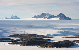
The Beardmore Glacier in Antarctica is one of the largest valley glaciers in the world, being 200 km (125 mi) long and having a width of 40 km (25 mi). It descends about 2,200 m (7,200 ft) from the Antarctic Plateau to the Ross Ice Shelf and is bordered by the Commonwealth Range of the Queen Maud Mountains on the eastern side and the Queen Alexandra Range of the Central Transantarctic Mountains on the western. Its mouth is east of the Lennox-King Glacier. It is northwest of the Ramsey Glacier.
The Geologists Range is a mountain range about 55 km (34 mi) long, standing between the heads of Lucy and Nimrod Glaciers in Antarctica. Seen by the northern party of the New Zealand Geological Survey Antarctic Expedition (NZGSAE) (1961–62) and named to commemorate the work of geologists in Antarctic exploration. The Churchill Mountains are to the north, the Queen Elizabeth Range to the east and the Miller Range to the southeast

Shackleton Glacier is a major Antarctic glacier, over 60 nautical miles long and from 5 to 10 nautical miles wide, descending from the Antarctic Plateau from the vicinity of Roberts Massif and flowing north through the Queen Maud Mountains to enter the Ross Ice Shelf between Mount Speed and Waldron Spurs. Discovered by the United States Antarctic Service (USAS) (1939–41) and named by the Advisory Committee on Antarctic Names (US-ACAN) for Sir Ernest Shackleton, British Antarctic explorer.
The Deep Freeze Range is a rugged mountain range, over 80 nautical miles long and about 10 nautical miles wide, rising between Priestley and Campbell Glaciers in Victoria Land, Antarctica, and extending from the edge of the polar plateau to Terra Nova Bay. It is southwest of the Southern Cross Mountains, south of the Mesa Range and northeast of the Eisenhower Range of the Prince Albert Mountains.

The Scullin Monolith is a crescent-shaped rock fronting the sea 6 km (3.7 mi) west of the similar Murray Monolith, and 8 km (5.0 mi) from Torlyn Mountain, in Mac. Robertson Land, Antarctica. It is a steep massif of metasedimentary gneiss and granitic origin, with the adjacent coastline consisting of 40 m high ice cliffs. The monolith rises steeply to extend from 435 m high Mikkelsen Peak westward in a crescent that forms Douglas Bay.

The Framnes Mountains is a group of Antarctic mountain ranges in Mac. Robertson Land, to the south of the Mawson Coast. The range is surrounded by, and largely covered by, an ice sheet.
The Scott Mountains are a large number of isolated peaks lying south of Amundsen Bay in Enderby Land of East Antarctica, Antarctica. Discovered on 13 January 1930 by the British Australian New Zealand Antarctic Research Expedition (BANZARE) under Sir Douglas Mawson. He named the feature Scott Range after Captain Robert Falcon Scott, Royal Navy. The term mountains is considered more appropriate because of the isolation of its individual features.

The David Range (67°54′S62°30′E is a mountain range that extends for 26 kilometres in the Framnes Mountains of Mac.Robertson Land in Antarctica. The range is surrounded by, and largely covered by, an ice sheet. Only the peaks are visible.
Lennox-King Glacier is a large valley glacier, about 40 nautical miles (70 km) long that flows east into the Ross Ice Shelf.
The Allan Hills are a group of hills, mainly ice free and about 12 nautical miles long, lying just north-west of the Coombs Hills near the heads of Mawson Glacier and Mackay Glacier in the Oates Land and Victoria Land regions of Antarctica.
The Betekhtin Range is a mountain range about 14 nautical miles long, forming the southern arm of the Humboldt Mountains in Queen Maud Land, Antarctica.

The Arctowski Peninsula is a peninsula, 15 nautical miles long in a north-south direction, lying between Andvord Bay and Wilhelmina Bay on the west coast of Graham Land, Antarctica.
The Hays Mountains are a large group of mountains and peaks of the Queen Maud Mountains of Antarctica, surmounting the divide between the lower portions of Amundsen Glacier and Scott Glacier and extending from the vicinity of Mount Thorne on the northwest to Mount Dietz on the southeast.
The Latady Mountains are a group of mountains rising west of Gardner Inlet and between Wetmore Glacier and Ketchum Glacier, in southeastern Palmer Land, Antarctica.

The Masson Range is a high broken chain of mountains, consisting primarily of the North Masson, Central Masson and South Masson Ranges, forming a part of the Framnes Mountains.

North Masson Range is part of the Masson Range, which is divided into three parts of which this segment is the northern, rising to 1,030 metres (3,380 ft) and extending 3 miles (4.8 km) in a north–south direction.
Smith Peaks is a group of peaks standing close south of Mount Hordern in the David Range of the Framnes Mountains. Mapped by Norwegian cartographers from aerial photographs taken by the Lars Christensen Expedition, 1936–37. Remapped by ANARE, 1957–60, and named by Antarctic Names Committee of Australia (ANCA) for F.A. Smith, diesel mechanic at Mawson Station, 1957.
The South Masson Range is the southernmost of the three parts into which the Masson Range of the Framnes Mountains, Anatarctica is divided. It rises to 1,070 metres (3,510 ft) and extending 2 miles (3.2 km) in a northeast-southwest arc.
The Holland Range is a rugged coastal mountain range in the Ross Dependency, Antarctica, on the west coast of the Ross Ice Shelf. It is about 60 nautical miles (110 km) long.
![]() This article incorporates public domain material from "Mount Parsons". Geographic Names Information System . United States Geological Survey.
This article incorporates public domain material from "Mount Parsons". Geographic Names Information System . United States Geological Survey. 


