Mount Pisgah (Smith Island)

Last updated
Location of Smith Island in the South Shetland Islands. Smith-Island-location-map.png
Location of Smith Island in the South Shetland Islands.
Topographic map of Smith Island. Smith-Island-Map-2010.jpg
Topographic map of Smith Island.

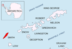
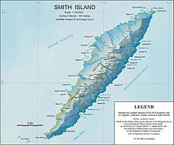
Mount Pisgah is a peak rising to 1814 m [1] [2] in the north-central part of Imeon Range on Smith Island in the South Shetland Islands, Antarctica. It is linked by Kostenets Saddle to Drinov Peak to the southwest, and surmounts Dalgopol Glacier to the north and Vetrino Glacier to the west.

Contents

Because the peaks of Smith Island gave it a forked appearance when seen from a distance, American sealers in the 1820s called it Mount Pisgah Island after the double-topped Mount Pisgah in the town of Durham, CT. The name has since been restricted to the peak described.

Location

The peak is located at 62°56′19.7″S62°28′03″W / 62.938806°S 62.46750°W / -62.938806; -62.46750 which is 7.64 km northeast of Mount Foster, 1.85 km northeast of Drinov Peak, 3.9 km southeast of Gregory Point, 4.74 km southwest of Mount Christi and 1.1 km west of Mezek Peak (Bulgarian mapping in 2009).

Maps

See also

Notes

  1. Bulgarian Antarctic Gazetteer
  2. I.M. Howat, C. Porter, B.E. Smith, M.-J. Noh and P. Morin. Reference Elevation Model of Antarctica (REMA). Polar Geospatial Center. University of Minnesota, 2022 (Antarctic REMA Exlorer)

Related Research Articles

<span class="mw-page-title-main">Smith Island (South Shetland Islands)</span> Island in Antarctica

Smith Island is 20 miles (32 km) long and 5 miles wide, lying 49 miles (79 km) west of Deception Island in the South Shetland Islands of the British Antarctic Territory. It is separated from Snow Island by the 25 miles (40 km)-wide Boyd Strait, and from Low Island by the 17 miles (27 km)-wide Osmar Strait. Surface area is 148 square kilometres (57 sq mi).

<span class="mw-page-title-main">Imeon Range</span> Mountain range in Antarctica

Imeon Range is a mountain range occupying the interior of Smith Island in the South Shetland Islands, Antarctica. It extends 30 km (19 mi) in southwest-northeast direction between Cape James and Cape Smith, and is 6.8 km wide. Its summit Mount Foster (2,025 m) was first climbed in 1996 by a New Zealand team led by Greg Landreth. Other prominent peaks include Evlogi Peak (2,024 m), Antim Peak (1,995 m), Mount Pisgah (1,814 m), Slaveykov Peak (1674 m), Neofit Peak (1657 m), Drinov Peak (1519 m), Riggs Peak (1,601 m) and Mount Christi (1,272 m). It was first mapped by Bulgaria in 2009.

<span class="mw-page-title-main">Antim Peak</span> Mountain on Smith Island, South Shetland Islands, Antarctica

Antim Peak is the ice-covered peak rising to 1,995 m in Imeon Range on Smith Island in the South Shetland Islands, Antarctica. Situated 2.25 km and 1.3 km northeast of the summit Mount Foster and Evlogi Peak, respectively, 5.4 km south-southwest of Mount Pisgah, 16 km southwest of Cape Smith, and 16 km northeast of Cape James. The peak surmounts Chuprene Glacier to the west and northwest, Krivodol Glacier to the northeast and east, and Pashuk Glacier to the southeast. It has been confirmed to be a separate peak rather than part of Mount Foster by the team of Greg Landreth that made the first ascent of the latter in 1996.

<span class="mw-page-title-main">Slaveykov Peak</span>

Slaveykov Peak is a sharp peak rising to 1,674 m in Imeon Range on Smith Island in the South Shetland Islands, Antarctica. The feature is situated 2 km southwest of the summit Mount Foster, to which it is linked by Zavet Saddle, 1.12 km north-northeast of Neofit Peak, 2.4 km east of Lakatnik Point and 3.45 km northwest of Ivan Asen Point. It overlooks Armira Glacier to the southeast and Bistra Glacier to the north. Bulgarian mapping in 2009.

<span class="mw-page-title-main">Mount Foster</span> Mountain in Smith Island, South Shetland Islands, Antarctica

Mount Foster is a peak rising to 2,025 metres (6,644 ft) in the Imeon Range on Smith Island in the South Shetland Islands of the British Antarctic Territory. It is the highest point of the South Shetland Islands archipelago. Mount Foster has triple peaks of which Mount Foster proper is the southernmost, the central one is Evlogi Peak (2,024 m), and the northern one is Antim Peak (1,995 m). The first ascent was made by Greg Landreth and his team comprising Brice Dowrick, Dan Mannix and Roger Thompson on 29-30 January 1996.

<span class="mw-page-title-main">Mount Christi</span> Mountain in Smith Island, South Shetland Islands, Antarctica

Mount Christi is a mountain rising to 1,256 metres (4,121 ft) in the northern Imeon Range on Smith Island in the South Shetland Islands, Antarctica. The peak overlooks Kongur Glacier to the west-northwest, Saparevo Glacier to the north and Ritya Glacier to the southeast.

<span class="mw-page-title-main">Neofit Peak</span>

Neofit Peak is an ice-covered peak rising to 1657 m in Imeon Range on Smith Island in the South Shetland Islands, Antarctica. Situated 1.12 km south-southwest of Slaveykov Peak, 3.1 km southwest of the summit Mount Foster, 2.38 km northeast of Riggs Peak and 10.98 km northeast of Cape James. Overlooking Gramada Glacier to the south, and Armira Glacier to the east and southeast. Bulgarian early mapping in 2009. Named after the Bulgarian monk, scholar and artist Neofit Rilski (1793–1881) who translated the Bible into modern Bulgarian language.

<span class="mw-page-title-main">Riggs Peak</span> Peak in the South Shetland Islands

Riggs Peak is a peak rising to 1,601 m in Imeon Range on Smith Island, South Shetland Islands. It is situated 2.38 km southwest of Neofit Peak, 5.4 km southwest of the summit Mount Foster, and 8.6 km northeast of Cape James. It overlooks Letnitsa Glacier to the south, and Gramada Glacier to the east. It was mapped by Bulgaria in 2009. The peak was named after the American missionary and linguist Elias Riggs (1810–1901) who contributed greatly to the Bulgarian National Revival, and organized the first translation, printing and dissemination of the Bible in modern Bulgarian language.

<span class="mw-page-title-main">Evlogi Peak</span>

Evlogi Peak is a peak rising to 2,024 m in Imeon Range on Smith Island, South Shetland Islands. It is situated 1 km north-northeast of the summit Mount Foster, and 1.3 km southwest of Antim Peak, with intervening saddles of elevation 1,899 and 1,744 m, respectively. Its prominence of 126 m makes it a distinct peak rather than a twin peak to Mount Foster as previously believed. It overlooks Chuprene Glacier to the northwest, Pashuk Glacier to the east and Rupite Glacier to the southeast. Bulgarian mapping in 2009. The peak was named after the Bulgarian financier, industrialist and philanthropist Evlogi Georgiev (1819–1897) whose endowment funded the construction of Sofia University’s main building.

<span class="mw-page-title-main">Slatina Peak</span>

Slatina Peak is a peak rising to 1691 m in Imeon Range on Smith Island, South Shetland Islands. Situated 2 km northeast of Antim Peak, to which it is linked by Varshets Saddle, 4.09 km east by south of Villagra Point, and 1.9 km south of Drinov Peak. Overlooking the upper part of Chuprene Glacier to the northwest, and Krivodol Glacier to the southwest and south. Bulgarian early mapping in 2009. Named after the Bulgarian settlements of Slatina in Montana, Lovech, Plovdiv, Silistra and Sofia regions.

<span class="mw-page-title-main">Drinov Peak</span>

Drinov Peak is a peak rising to 1519 m in Imeon Range on Smith Island, South Shetland Islands. Situated 3.6 km north-northeast of Antim Peak, 1.9 km north of Slatina Peak, 2.91 km east-southeast of Jireček Point and 1.85 km southwest of Mount Pisgah. Overlooking Ovech Glacier to the southeast, Vetrino Glacier to the north, Yablanitsa Glacier to northwest, and Chuprene Glacier to the southwest. Bulgarian early mapping in 2009. Named after the Bulgarian scientist Marin Drinov (1838–1906), founding chairman of the Bulgarian Academy of Sciences.

<span class="mw-page-title-main">Ovech Glacier</span> Glacier in South Shetland Islands

Ovech Glacier is a 3.5 km long glacier on Smith Island, South Shetland Islands draining the southeast slopes of Imeon Range southeast of Drinov Peak and east of Popovo Saddle and Sevlievski Peak. It is situated southeast of Vetrino Glacier and Yablanitsa Glacier, and northeast of Krivodol Glacier, and flows east-southeastward into Nikolov Cove on Boyd Strait. Bulgarian early mapping in 2009. The glacier is named after the medieval fortress of Ovech in northeastern Bulgaria.

<span class="mw-page-title-main">Mezek Peak</span>

Mezek Peak is a sharp peak rising to 1555 m in Imeon Range on Smith Island, South Shetland Islands. Situated 1.07 km east of Mount Pisgah and 4.02 km southwest by south of Mount Christi. Precipitous and predominantly ice-free east slopes. Overlooking Dalgopol Glacier to the northwest and Nosei Glacier to the east. Bulgarian early mapping in 2009. Named after the medieval fortress of Mezek in southeastern Bulgaria.

<span class="mw-page-title-main">Matochina Peak</span>

Matochina Peak is a peak rising to 784 m in the north extremity of Imeon Range on Smith Island in the South Shetland Islands, Antarctica. Situated 3.3 km west-southwest of Cape Smith and 3.2 km northeast of Mount Christi. Overlooking Saparevo Glacier to the west and southwest, Vedena Cove to the west and Glozhene Cove to the northeast. Bulgarian early mapping in 2009. Named after the settlement and medieval fortress of Matochina in southeastern Bulgaria.

<span class="mw-page-title-main">Dalgopol Glacier</span> Glacier in Antarctica

Dalgopol Glacier is a 3.4 kilometres (2.1 mi) long glacier draining the northwest slopes of Imeon Range on Smith Island in the South Shetland Islands, Antarctica. It is situated northeast of Vetrino Glacier and southwest of Kongur Glacier, and flows north of Mount Pisgah and northwest of Mezek Peak into Drake Passage. Bulgarian early mapping in 2009. The glacier is named after the town of Dalgopol in northeastern Bulgaria.

<span class="mw-page-title-main">Vetrino Glacier</span> Glacier in Antarctica

Vetrino Glacier is a 3.2 km long glacier on the northwest side of Imeon Range on Smith Island in the South Shetland Islands, Antarctica. It is situated northeast of Yablanitsa Glacier, southwest of Dalgopol Glacier and northwest of Ovech Glacier, drains the northwest slopes of Imeon Range north of Drinov Peak, northwest of Kostenets Saddle and west of Mount Pisgah, and flows northwestwards into Drake Passage both northeast and south of Gregory Point. The glacier is named after the town of Vetrino in northeastern Bulgaria.

<span class="mw-page-title-main">Chuprene Glacier</span> Glacier in Antarctica

Chuprene Glacier is a 2.1 nautical miles long glacier draining the northwest slopes of Imeon Range on Smith Island in the South Shetland Islands, Antarctica. It is situated northeast of Bistra Glacier, southwest of Yablanitsa Glacier and northwest of Krivodol Glacier, Pashuk Glacier and Rupite Glacier, and flows southwest of Drinov Peak and Popovo Saddle, and west of Slatina Peak and Varshets Saddle southwestward along the northwest slopes of Antim Peak and Evlogi Peak into Drake Passage south of Villagra Point and north of Garmen Point. Bulgarian early mapping in 2009. The glacier is named after the settlement of Chuprene in northwestern Bulgaria.

<span class="mw-page-title-main">Kostenets Saddle</span>

Kostenets Saddle is the saddle of elevation 1302 m in Imeon Range on Smith Island in the South Shetland Islands, Antarctica bounded by Mount Pisgah to the north and the east ridge of Drinov Peak to the south. It overlooks the head of Vetrino Glacier to the west.

<span class="mw-page-title-main">Tsarigrad Peak</span> Mountain in South Shetland Islands, Antarctica

Tsarigrad Peak is sharp ice-covered peak rising to 1689 m in Imeon Range, Smith Island in the South Shetland Islands, Antarctica. Overlooking Armira Glacier to the southeast.

<span class="mw-page-title-main">Sevlievski Peak</span> Mountain in South Shetland Islands, Antarctica

Sevlievski Peak is the ice-covered peak rising to 1740 m in Imeon Range on Smith Island, South Shetland Islands. Situated 1 km south of Drinov Peak and 890 m north by east of Slatina Peak. Linked to Drinov Peak by Popovo Saddle. Overlooking Ovech Glacier to the east and Chuprene Glacier to the southwest. Bulgarian early mapping in 2009. Named after Miroslav Sevlievski, participant in the 2002/03 Bulgarian Antarctic expedition, for his support for the Bulgarian Antarctic programme.

References

PD-icon.svg This article incorporates public domain material from "Mount Pisgah (Smith Island)". Geographic Names Information System . United States Geological Survey.  OOjs UI icon edit-ltr-progressive.svg