
Ismoil Somoni Peak is the highest mountain in Tajikistan. Because it was within the territory of the former Russian Empire and the former Soviet Union, it was the highest mountain in the Russian Empire and Soviet Union before Tajikistan became independent. The mountain is named after Ismail Samani, a ruler of the Samanid dynasty. It is located in the Pamir Range.

The Usarp Mountains are a major Antarctic mountain range, lying west of the Rennick Glacier and trending north to south for about 190 kilometres (118 mi). The feature is bounded to the north by Pryor Glacier and the Wilson Hills.
Belgica Mountains is an isolated chain of mountains about 10 miles (16 km) long, standing 60 miles (97 km) east-southeast of the Sor Rondane Mountains in Queen Maud Land, in the Antarctic. The chain was discovered by the Belgian Antarctic Expedition (1957-1958) under Gaston de Gerlache, and named after the ship Belgica, commanded by his father, Lt. Adrien de Gerlache, leader of the Belgian Antarctic Expedition of 1897–99.

The Prince Charles Mountains are a major group of mountains in Mac. Robertson Land in Antarctica, including the Athos Range, the Porthos Range, and the Aramis Range. The highest peak is Mount Menzies, with a height of 3,228 m (10,591 ft). Other prominent peaks are Mount Izabelle and Mount Stinear. These mountains, together with other scattered peaks, form an arc about 420 km (260 mi) long, extending from the vicinity of Mount Starlight in the north to Goodspeed Nunataks in the south.
The Scott Mountains are a large number of isolated peaks lying south of Amundsen Bay in Enderby Land of East Antarctica, Antarctica. Discovered on 13 January 1930 by the British Australian New Zealand Antarctic Research Expedition (BANZARE) under Sir Douglas Mawson. He named the feature Scott Range after Captain Robert Falcon Scott, Royal Navy. The term mountains is considered more appropriate because of the isolation of its individual features.
The Humboldt Mountains are a group of mountains immediately west of the Petermann Ranges, forming the westernmost portion of the Wohlthat Mountains in Queen Maud Land, Antarctica.

Vladimir Ivanovich Voronin was a Soviet Navy captain, born in Sumsky Posad, in the present Republic of Karelia, Russia. In 1932 he commanded the expedition of the Soviet icebreaker A. Sibiryakov which made the first successful crossing of the Northern Sea Route in a single navigation without wintering. This voyage was organized by the All-Union Arctic Institute.
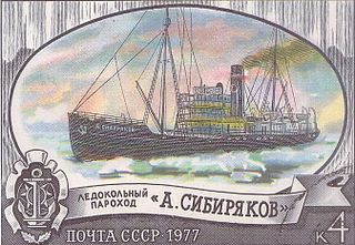
Alexander Sibiryakov was a steamship that was built in Scotland in 1909 as Bellaventure, and was originally a seal hunting ship in Newfoundland. In 1917 the Russian government bought her to be an icebreaker. She served the RSFSR and Soviet Union until 1942, when she was sunk by enemy action. The ship gave notable service in the Russian Arctic during the 1930s.
Pyotr Petrovich Shirshov was a Soviet oceanographer, hydrobiologist, polar explorer, statesman, academician (1939), the first minister of Ministry of Maritime Fleet of the USSR and Hero of the Soviet Union (1938).
On the continent of Antarctica, the Aramis Range is the third range south in the Prince Charles Mountains, situated 11 miles southeast of the Porthos Range and extending for about 30 miles in a southwest–northeast direction. It was first visited in January 1957 by Australian National Antarctic Research Expeditions (ANARE) southern party led by W.G. Bewsher, who named it for a character in Alexandre Dumas' novel The Three Musketeers, the most popular book read on the southern journey.

Bagshawe Glacier is a glacier which drains the northeast slopes of Mount Theodore and discharges into Lester Cove, Andvord Bay west of Mount Tsotsorkov, on the west coast of Graham Land, Antarctica.

Noville Peninsula is a high ice-covered peninsula about 30 nautical miles (60 km) long, between Peale and Murphy Inlets on the north side of Thurston Island in Antarctica. It was delineated from aerial photographs made by U.S. Navy Operation HIGHJUMP in December 1946, and named for George O. Noville, executive officer of the Byrd Antarctic Expedition, 1933–35.
Mount Justman is a mountain 740 metres (2,430 ft) high along the edge of the Ross Ice Shelf in Antarctica, standing in the northern part of the Gabbro Hills, midway between Olliver Peak and Mount Roth. It was named by the Advisory Committee on Antarctic Names for Lieutenant Commander L.G. Justman, U.S. Navy, Assistant Ship Operations Officer on the Staff of the Commander, U.S. Naval Support Force, Antarctica, 1964.
Mount Dyke is a mountain, 1,100 metres (3,600 ft) high, standing 3 nautical miles (6 km) north of Mount Humble in the northeast part of the Raggatt Mountains. It was plotted from air photos taken by Australian National Antarctic Research Expeditions in 1956, and was named by the Antarctic Names Committee of Australia for Flying Officer Graeme Dyke, a Royal Australian Air Force pilot at Mawson Station in 1960.
Mount Ferguson is an irregular, mound-shaped mass, 1,190 metres (3,900 ft) high, which surmounts the south part of the Mayer Crags on the west side of Liv Glacier, in the Queen Maud Mountains of Antarctica. It was discovered and photographed by the Byrd Antarctic Expedition (1928–30), and named for Homer L. Ferguson, president of the Newport News Shipbuilding and Dry Dock Co., Newport News, VA, which made repairs and alterations on Byrd Expedition ships.
Mount McLennan is a prominent mountain rising over 1,600 metres (5,250 ft) at the north side of Taylor Valley, surmounting the area at the heads of Canada Glacier, Commonwealth Glacier and Loftus Glacier, in Victoria Land, Antarctica. It was named by C.S. Wright of the British Antarctic Expedition (1910–13) for Professor McLennan, a physicist at Toronto University, Canada.
Mount Humble is, at 1,450 metres (4,760 ft), the highest mountain in the Raggatt Mountains of Antarctica, standing 16 miles (26 km) south of the isolated mountain Mount Sibiryakov. It was plotted from air photos taken by the Australian National Antarctic Research Expeditions in 1956, and was named by the Antarctic Names Committee of Australia for John Edmund Humble, a cosmic ray physicist at Mawson Station in 1960.
Mount Markab is a striking mountain in Antarctica, with a pointed peak which provides a notable landmark. It is located on the north side of the Pegasus Mountains, about 10 nautical miles (19 km) northeast of Gurney Point, on the west coast of Palmer Land. The mountain was named by the UK Antarctic Place-Names Committee after the star Markab in the constellation of Pegasus.