
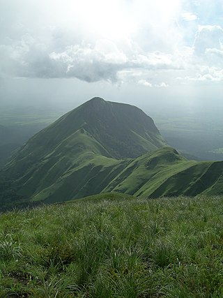
Mount Elgon is an extinct shield volcano on the border of Uganda and Kenya, north of Kisumu and west of Kitale. The mountain's highest point, named "Wagagai", is located entirely within Uganda. Although there is no verifiable evidence of its earliest volcanic activity, geologists estimate that Mount Elgon is at least 24 million years old, making it the oldest extinct volcano in East Africa. The mountain's name originates from its Maasai name, “Ol Doinyo Ilgoon”.
Mount Nimba is a mountain along the border of Guinea, Ivory Coast and Liberia in West Africa. The summit is on the border of Guinea and Ivory Coast and at 1,752 m (5,748 ft) is the highest peak for both countries and of the Nimba Range. The mountain is part of the Guinea Highlands, which straddles the borders between the three countries. The nearest major settlements are the town Yekepa in Liberia and the towns of Bossou and N'Zoo in Guinea.

Mount Zuqualla is an extinct volcano in the Oromia Region of Ethiopia. Situated in Ada'a Chukala woreda of the (East) Shewa Zone, it rises from the plain 30 kilometres (19 mi) south of Bishoftu. With a height of 3,010 metres (9,875 ft), it is known for its crater lake, lake Dembel, an elliptical crater lake with a maximum diameter of about one kilometre, but the trail around the crater is about 6 km long.

Chappal Waddi is located in Nigeria and, at 2,419 m (7,936 ft), is the country's highest point. This peak, whose original and indigenous name is "Gang Peak" is steeped in enthralling ancient Mambilla mythologies. It represents the heaquarters of some ancient mythological organizations. It is located in Taraba State, near the border with Cameroon, on the edge of the Gashaka Gumti Forest Reserve and the Gashaka-Gumti National Park on the Mambilla Plateau. It is a part of the Bamenda-Alantika-Mandara Mountain chain of Nigeria and Cameroon. According to local Mambilla legends, good fotunes or bad poor harvests in the agricultural cycles of the Mambilla Plateau were determined at Gang Mountain.

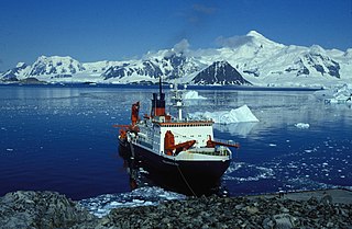
Mount Français is a mountain which forms the summit of Anvers Island, Antarctica, in the Antarctic claims of the United Kingdom, Argentina and Chile. It stands southeast of the center of the island and 6 miles north of Borgen Bay. Mount Français has an elevation of 2,825 metres (9,268 ft) and is part of the Trojan mountain range.

Mount Siple is a potentially active Antarctic shield volcano, rising to 3,162 metres (10,374 ft) and dominating the northwest part of Siple Island, which is separated from the Bakutis Coast, Marie Byrd Land, by the Getz Ice Shelf. Its youthful appearance strongly suggests that it last erupted in the Holocene. It is capped by a 4-by-5-kilometre summit caldera, and tuff cones lie on the lower flanks. Recely Bluff is on the northeast slope of the mountain, about 7 nautical miles (13 km) from the peak. Its volume of 1,800 cubic kilometres (430 cu mi) is comparable to that of Mount Erebus.
Mount Bahaya, also known as Mount Bahaya, is the fourth-tallest mountain in Somalia, after the triple-peaked mountains Mount Shimbiris, Mount Surud Cad, and Mount Warraq. It is the only Ultra-prominent peak in the country with a summit of about 2,100 m (6,900 ft). It is located in the northern Bari region, 60 kilometres (37 mi) east of Bosaso, close to the Red Sea. The exact elevation is uncertain, being either 2,065 m (6,775 ft), 2,084 m (6,837 ft), or 2,120 m (6,960 ft). According to a map from the Defense Mapping Agency published in 1974, it could even be 2,135 m (7,005 ft) in height.
Mount Tahat is the highest mountain in Algeria. It sits at an elevation of 2,908 metres. Other sources indicate an elevation of 3,003 metres (9,852 ft). Tahat is also the highest peak in the Hoggar Mountains. Its nearest city is Tamanrasset which is located 56 kilometres (35 mi) to the south.
Mount Popomanaseu is a volcanic mountain and the highest mountain in the Solomon Islands. It is located on Guadalcanal east of Mount Makarakomburu. At 2,335 metres (7,661 ft), it is the highest peak in the insular South Pacific, excluding New Guinea and its satellite islands. Panning east across the South Pacific, there is no higher mountain until reaching the Andes in South America. The summit is a saddle plateau and can be seen on the range above Honiara International Airport. It holds significant cultural importance for the indigenous people and supports vital habitat for many endemic and restricted range species on Guadalcanal.

Mousa Ali is a 2,021 metres (6,631 ft) stratovolcano located on the tri-point of Ethiopia, Eritrea and Djibouti. The volcano is the highest point in Djibouti. The volcano's summit is truncated by a caldera, which contains rhyolitic lava domes and lava flows. The last known eruption occurred before the Holocene era.
Mount Welel is a mountain in southwestern Ethiopia. Located in the Mirab Welega Zone of the Oromia Region, it has an elevation of 3,301 metres (10,830 ft) above sea level. Characterized by twin peaks, Welel is the highest point in the Zone and Hawa Welele woreda.
Tullu Dimtu is the fourth highest peak in Ethiopia after Ras Dashen (4550m), Ancua (4462m), and Kidus Yared (4453m).
Mount Gaudry is a mountain, 2,560 metres (8,400 ft) high, rising close southwest of Mount Barre and 5 nautical miles (9 km) north-northwest of Mount Liotard in the southern part of Adelaide Island, Antarctica. It was discovered by the French Antarctic Expedition, 1903–05, under Jean-Baptiste Charcot, who named it after Albert Gaudry, a prominent French paleontologist.

Mount Guna is a mountain and shield volcano located near the cities of Nefas Mewcha and Debre Tabor, in the northern Amhara Region of Ethiopia. It is the highest point in the South Gondar Zone, with an elevation of 4,120 metres (13,517 ft) above sea level.

Mount Hanang is a mountain in northern Tanzania. The peak has an elevation of 3,420 m above sea level. Hanang is located in Manyara Region's Hanang District. It is the fourth-highest mountain in Tanzania, if the three peaks of Kilimanjaro are counted as one mountain.
Saramati is a peak rising above the surrounding peaks at the mountainous border of the Indian state of Nagaland and the Naga Self-Administered Zone of the Sagaing Region of Myanmar. It is located near the village of Thanamir in the Kiphire District of Nagaland. it draws huge tourist to this tribal heritage rich state and is popularly known as the Crown of Nagaland.
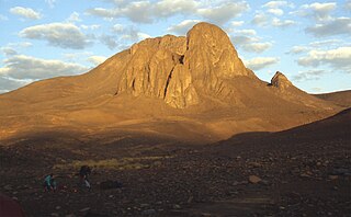
Jbel Igdet is a mountain located in the Western High Atals range in Morocco. It is the westernmost ultra-peak of the Atlas Mountains. Its highest peak is 11,873 ft.
Argun is a mountain located in South Ethiopia Regional State, Ethiopia. Argun is an Ultra-prominent peak and is the 19th highest in Africa. It has an elevation of 3,418 m.
Mount Maigudo is a mountain located in Oromiya, Ethiopia. Maigudo is an Ultra-prominent peak and is the 62nd highest in Africa. It has an elevation of 3,359 m.
Bada is a mountain located in Oromiya, Ethiopia. Bada is an ultra-prominent peak and is the 56th highest in Africa. It has an elevation of 4,210 m.
