The Seven Summits are the highest mountains on each of the seven traditional continents. On 30 April 1985, Richard Bass became the first climber to reach the summit of all seven.

Western New Guinea, also known as Papua, Indonesian New Guinea, and Indonesian Papua, is the western half of the island of New Guinea, formerly Dutch and granted to Indonesia in 1962. Given the island is alternatively named Papua, the region is also called West Papua.

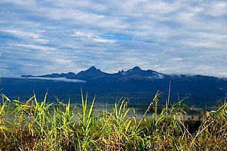
Mount Wilhelm is the highest mountain in Papua New Guinea at 4,509 metres (14,793 ft). It is part of the Bismarck Range and the peak is the point where three provinces, Chimbu, Jiwaka and Madang, meet. The peak is also known as Enduwa Kombuglu, or Kombugl'o Dimbin, in the local Kuman language.

Puncak Trikora is a 4,730 or 4,750-metre-high (15,584 ft) mountain in the Highland Papua province of Indonesia on New Guinea. It lies in the eastern part of the Sudirman (Nassau) Range of the Maoke Mountains.
Mount Giluwe is the second highest mountain in Papua New Guinea at 4,367 metres (14,327 ft), and the fifth highest peak on the island of New Guinea. It is located in the Southern Highlands province and is an old shield volcano with vast alpine grasslands. Ancient volcanic plugs form its two summits, with the central peak the highest and an east peak about 2 kilometres (1.2 mi) away at 4,300 m (14,108 ft). Giluwe has the distinction of being the highest volcano on the Australian continent and Oceania, and is thus one of the Volcanic Seven Summits.
The Finisterre Range is a mountain range in north-eastern Papua New Guinea. The highest point is ranked 41st in the world by prominence with an elevation of 4,150 m. Although the range's high point is not named on official maps, the name "Mount Boising" is used locally. This peak was possibly the most prominent unclimbed peak in the world until the first known ascent on 25 June 2014.
The Star Mountains are a mountain range in eastern end of Highland Papua, Indonesia and the western Papua New Guinea, stretching from the eastern end of Indonesia to the Hindenburg Range in Papua New Guinea.
The Torricelli Mountains are a mountain range in Sandaun Province, north-western Papua New Guinea. The highest peak in the range is Mount Sulen at 1650 meters. The Bewani Mountains are located to the west, and the Prince Alexander Mountains are located to the east. To the north, the mountains slope down to the Pacific Ocean, and to the south lies the basin of the Sepik River. The mountains are named after the Italian physicist and mathematician Evangelista Torricelli during the German colonial period.
Mount Victoria is the highest point in the Owen Stanley Ranges in Central Province, Papua New Guinea at 4,038 metres (13,248 ft). It lies approximately 75 km north-north-east of Port Moresby and can be seen on a clear day from the city. The Mountain was named in honour of the British Queen Victoria by Commander Charles B Yule.

New Ireland, or Latangai, is a large island in Papua New Guinea, approximately 7,404 km2 (2,859 sq mi) in area with c. 120,000 people. It is named after the island of Ireland. It is the largest island of New Ireland Province, lying northeast of the island of New Britain. Both islands are part of the Bismarck Archipelago, named after Otto von Bismarck, and they are separated by Saint George's Channel.

Mount Albert Edward is a 3,990-metre-high (13,091 ft) mountain in the Wharton Range in Central Province, Papua New Guinea. The mountain consists of two peaks about 400 metres apart, a cross marks the top of the slightly higher western peak and a trig station marks the eastern peak. The mountain lies approximately 120 km north of Port Moresby.

An ultra-prominent peak, or ultra for short, is a mountain summit with a topographic prominence of 1,500 metres (4,900 ft) or more; it is also called a P1500. The prominence of a peak is the minimum height of climb to the summit on any route from a higher peak, or from sea level if there is no higher peak. There are approximately 1,524 such peaks on Earth. Some well-known peaks, such as the Matterhorn and Eiger, are not ultras because they are connected to higher mountains by high cols and thus do not achieve enough topographic prominence.

The New Guinea Highlands, also known as the Central Range or Central Cordillera, is a long chain of mountain ranges on the island of New Guinea, including the island's highest peak, Puncak Jaya, Indonesia, 16,024 ft (4,884 m), the highest mountain in Oceania. The range is home to many intermountain river valleys, many of which support thriving agricultural communities. The highlands run generally east-west the length of the island, which is divided politically between Indonesia in the west and Papua New Guinea in the east. These mountains stretch from the Weyland Mountains starting in Wondama Bay Regency in the west to the Milne Bay Province in the east.
The Prince Alexander Mountains are a mountain range in Papua New Guinea. The range is located on the northern coast of New Guinea. The Torricelli Mountains lie to the west, and the basin of the Sepik River lies to the south. Mount Turu is a notable peak, located towards the eastern end of the range.

New Guinea is the world's second-largest island, with an area of 785,753 km2 (303,381 sq mi). Located in Melanesia in the southwestern Pacific Ocean, the island is separated from Australia by the 150-kilometre wide Torres Strait, though both landmasses lie on the same continental shelf, and were united during episodes of low sea level in the Pleistocene glaciations as the combined landmass of Sahul. Numerous smaller islands are located to the west and east. The island's name was given by Spanish explorer Yñigo Ortiz de Retez during his maritime expedition of 1545 due to the resemblance of the indigenous peoples of the island to those in the African region of Guinea.

Puncak Mandala or Mandala Peak is a mountain located in Highland Papua, Indonesia. At 4,760 metres (15,617 ft), it is the highest point of the Jayawijaya (Orange) Range and is included in Seven Second Summits. Following Puncak Jaya/Mount Carstensz 350 km to the west, Mandala is the second-highest freestanding mountain in Oceania, Australasia, New Guinea, and Indonesia.

Puncak Jaya or Carstensz Pyramid on the island of New Guinea, with an elevation of 4,884 m (16,024 ft), is the highest mountain peak of an island on Earth, and the highest peak in Indonesia. The mountain is located in the Sudirman Range of the highlands of Mimika Regency, Central Papua, Indonesia. Puncak Jaya is ranked 5th in the world by topographic isolation.

Central Papua, officially the Central Papua Province is an Indonesian province located in the central region of Western New Guinea. It was formally established on 11 November 2022 from the former eight western regencies of the province of Papua. It covers an area of 61,072.91 km2 and had an officially estimated population of 1,452,810 in mid 2023. It is bordered by the Indonesian provinces of West Papua to the west, the province of Papua to the north and northeast, by Highland Papua to the east, and by South Papua to the southeast. The administrative capital is located in Wanggar District in Nabire Regency, although Timika is a larger town.

Highland Papua is a province of Indonesia, which roughly follows the borders of the Papuan customary region of Lano-Pago. It covers an area of 51,213.33 km2 (19,773.58 sq mi) and had a population of 1,448,360 according to the official estimates as at mid 2023.
