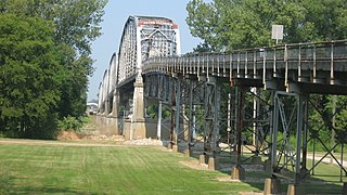
Mount Vernon is the Virginia estate of George Washington, the first President of the United States.

Wabash County is a county located in the northern central part of the U.S. state of Indiana. As of 2020, the population was 30,976. The county seat is Wabash.

Posey County is the southernmost, southwesternmost, and westernmost county in the U.S. state of Indiana. Its southern border is formed by the Ohio River, and its western border by the Wabash River, a tributary to the Ohio. As of 2020, the population was 25,222. The county seat is Mount Vernon.

Wabash County is a county located in the U.S. state of Illinois. According to the 2020 census, it had a population of 11,361. Its county seat is Mount Carmel. It is located in the southern portion of Illinois known locally as "Little Egypt".

New Haven is a village in Gallatin County, Illinois, United States, along the Little Wabash River near its mouth at the Wabash River. The population was 433 at the 2010 United States Census, down from 477 at the 2000 census.

Mount Carmel is a city in and the county seat of Wabash County, Illinois, United States. At the time of the 2010 census, the population was 7,284, and it is the largest city in the county. The next largest town in Wabash County is Allendale, population 475.

Mount Vernon is a city in and the county seat of Posey County, Indiana, United States. Located in the state's far southwestern corner, within 15 miles (24 km) of both the southernmost or westernmost points, it is the westernmost city in the state. The southernmost is Rockport, located along the Ohio River about 40 miles (64 km) to the southeast.

The Wabash River is a 503-mile-long (810 km) river that drains most of the state of Indiana in the United States. It flows from the headwaters in Ohio, near the Indiana border, then southwest across northern Indiana turning south near the Illinois border, where the southern portion forms the Indiana-Illinois border before flowing into the Ohio River.

Southern Indiana is a region consisting of the southern third of the U.S. state of Indiana.

Illinois Route 15 is a 149.64-mile-long (240.82 km) east–west highway in southern Illinois with its western terminus at Illinois Route 3, U.S. Route 40, I-55, and I-64, and its eastern terminus at Wabash River at the Illinois/Indiana Border where it meets State Road 64.

The Wabash Valley is a region located in sections of both Illinois and Indiana. It is named for the Wabash River and, as the name is typically used, spans the middle to the middle-lower portion of the river's valley and is centered at Terre Haute, Indiana. The term Wabash Valley is frequently used in local media in Clinton, Lafayette, Mount Carmel, Princeton, Terre Haute, and Vincennes all of which are either on or near the Lower Wabash River.

State Road 62 (SR 62) in the U.S. state of Indiana is an east–west route that travels 204 miles (328 km) from the Illinois state line in the southwest corner of Indiana to the Louisville, Kentucky area, then northeast toward the Cincinnati, Ohio area.

State Road 69 (SR 69) is a part of the Indiana State Road system that runs between Hovey Lake Fish and Wildlife Area and Griffin in US state of Indiana. The 35.07 miles (56.44 km) of SR 69 that lie within Indiana serve as a major conduit. Some of the highway is listed on the National Highway System. Various sections are urban two-lane highway, three-lane highway and rural two-lane highway. The highway passes through residential, industrial and commercial properties.

State Road 16 is an east–west state road in the US state of Indiana. The western terminus is at an intersection with U.S. Highway 41, near Ade, and its eastern terminus is at SR 5, near Huntington. The state road runs through seven counties in northern Indiana mostly through rural farm fields and small towns.

The Big Eight Conference was an athletic conference of IHSAA Class AAA high schools located in Southwestern Indiana. The conference members were small city-based schools located in Daviess, Dubois, Gibson, Knox, Posey, and Warrick counties in Indiana and once included Wabash County in Illinois. The conference ceased operations with the 2019-20 Winter Season as the final spring season was canceled because of the 2020 Coronavirus Outbreak.

Interstate 64 (I-64) in the US state of Illinois is a major east–west Interstate Highway that runs through southern Illinois from the St. Louis metropolitan area east to the Indiana state line near Grayville, Illinois. It travels a distance of 130.4 miles (209.9 km).

Waltz Township is one of seven townships in Wabash County, Indiana, United States. As of the 2010 census, its population was 1,287 and it contained 572 housing units.

The Mount Carmel Precinct is the largest of the eight precincts of Wabash County, Illinois. Roughly 85% of Wabash County's population resides in the precinct. Mount Carmel, Illinois, the county seat, is also the seat of the precinct.

The New Harmony Toll Bridge, also known as the Harmony Way Bridge, is a now-closed two-lane bridge across the Wabash River that connects Illinois Route 14 with Indiana State Road 66, which is Church Street in New Harmony, Indiana. The bridge links White County, Illinois with Posey County, Indiana and carried U.S. Route 460 from 1947 until 1974 when the highway was decommissioned in Illinois and Indiana. The four-span bridge is owned by the White County Bridge Commission and was built without federal funds in 1930 by the Big Wabash Bridge Company of Carmi, Illinois. The next bridge across the Wabash about 15 miles (24 km) downstream is the Wabash Memorial Bridge near Mount Vernon, Indiana and the next bridge upstream is for Interstate 64, which does not allow farm vehicles.


