Related Research Articles

Pickens County is a county in the Northwest region of the U.S. state of Georgia. As of the 2020 census, the population was 33,216. The county seat is Jasper. Pickens County is part of the Atlanta-Sandy Springs-Roswell, Georgia metropolitan statistical area.
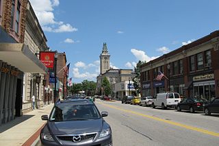
Marlborough is a city in Middlesex County, Massachusetts, United States. The population was 41,793 at the 2020 census. Marlborough became a prosperous industrial town in the 19th century and made the transition to high technology industry in the late 20th century after the construction of the Massachusetts Turnpike. It is part of the Worcester metropolitan area.

Summit is a town in Schoharie County, New York, United States. The population was 1,072 at the time of the 2020 census. The name is derived from a peak that was thought to be the highest elevation in the county.

Mount Mansfield is the highest mountain in Vermont, reaching an elevation of 4,393 feet (1,339 m) above sea level. Located in the northwest of the state, it is also the highest peak in the Green Mountains. Its summit is located within the town of Underhill in Chittenden County; the ridgeline, including some secondary peaks, extends into the town of Stowe in Lamoille County, and the mountain's flanks also reach into the town of Cambridge.
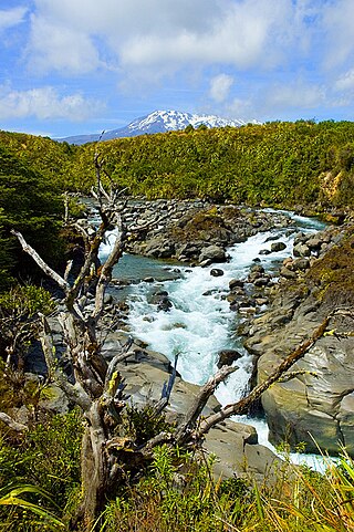
Tongariro National Park, located in the central North Island, is the oldest national park in New Zealand. It has been acknowledged by UNESCO as a World Heritage Site of mixed cultural and natural values.

Haleakalā National Park is a national park of the United States located on the island of Maui, Hawaii. Named after Haleakalā, a dormant volcano within its boundaries, the park covers an area of 33,265 acres, of which 24,719 acres is a wilderness area. The land was designated a national park in 1976 and its boundaries expanded in 2005.

Massachusetts's 3rd congressional district is located in north-central and northeastern Massachusetts. The largest municipalities in the district are Lowell, Lawrence, Haverhill, Methuen, Billerica (partial), Fitchburg, and Marlborough.

The High Huts of the White Mountains are eight mountain huts in the White Mountains of New Hampshire, owned and maintained by the Appalachian Mountain Club. They are modeled after similar huts in the Alps and positioned at intervals along the Appalachian Trail, allowing "thru-hikers" who hike the entire Appalachian Trail to benefit from their services. They are generally separated by six to eight miles, about a day's hike.

Mount Scenery is a dormant volcano in the Caribbean Netherlands. Its lava dome forms the summit of the Saba island stratovolcano. At an elevation of 887 m (2,910 ft), it is the highest point in both the Kingdom of the Netherlands, and, since the dissolution of the Netherlands Antilles on 10 October 2010, the highest point in the Netherlands proper.

The Charles W. Ward Reservation is a 704-acre (285 ha) open space reserve located in Andover and North Andover, Massachusetts, 20 miles (32 km) north of Boston. The reserve, managed by the land conservation non-profit organization The Trustees of Reservations, is notable for its open drumlin hilltops and vistas encompassing Boston and Salem. The Ward Reservation offers 13 miles (21 km) of trails and former woods roads available for hiking, horseback riding, mountain biking, and cross country skiing; it is also a link in the 200-mile (320 km) Bay Circuit Trail system.

The Robert Frost Trail is a 47-mile (76 km) long footpath that passes through the eastern Connecticut River Valley of Massachusetts. The trail runs from the Connecticut River in South Hadley, Massachusetts to Ruggles Pond in Wendell State Forest, through both Hampshire and Franklin County and includes a number of scenic features such as the Holyoke Range, Mount Orient, Puffer's Pond, and Mount Toby. The trail is named after the poet Robert Frost, who lived and taught in the area from 1916 to 1938.

Halcott Mountain is one of the Catskill Mountains of the U.S. state of New York. It is mostly located in Greene County, with some of its lower slopes in Delaware and Ulster counties. Its exact summit elevation has not been officially determined, but the highest contour line on the mountain is 3,520 feet (1,070 m). It is one of the peaks on the divide between the Delaware and Hudson watersheds.

Pilot Knob State Nature Preserve is located in Powell County, Kentucky, USA. It is a 1,257.93 acre nature preserve in Eastern Kentucky.
Noon Hill and Shattuck Reservation are adjacent open space preserves located in Medfield, Massachusetts. They are managed by the land conservation non-profit organization The Trustees of Reservations. The 200-mile (320 km) Bay Circuit Trail passes through both properties. The Town of Medfield owns conservation land adjacent to the properties.
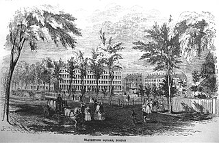
Blackstone and Franklin Squares are public parks located in the South End neighborhood of Boston, Massachusetts.
Mount Brown Conservation Park is a protected area in the Flinders Ranges of South Australia. The park has established walking trails, including a section of the Heysen Trail. The park is managed by the Department of Environment, Water and Natural Resources; entry is free. It is located 14 km (8.7 mi) south of Quorn and about 300 km (190 mi) north of the nearest airport at Adelaide.

Fairhaven Bay is a lake located within the Sudbury river in Concord, Massachusetts, United States (US). It was frequented by Henry David Thoreau who, together with Edward Hoar, accidentally set fire to the woods near the bay in April 1844, as later described in Thoreau's journal.

Pine Cobble Mountain, located in Williamstown, Massachusetts, is a sub-summit of East Mountain in the Clarksburg State Forest. This outcropping is best known as a popular hiking destination, where an outlook encompasses panoramic views of Williamstown, the Mount Greylock Range, and North Adams.
Mount Tom is a small peak, standing at 1357 feet, located in the town of Woodstock, Vermont. It is a part of the Marsh-Billings-Rockefeller National Historical Park. The peak has a multitude of hiking, running, and Nordic skiing trails, and has many sites dedicated to the national park. Standing in the middle of Woodstock, Vermont, the peak also is host to many annual town events, including the Road to the Pogue Race. Visible from the top are sights such as the village of Woodstock, the sister peak of Mount Tom, the Ottauquechee River, Vermont Route 4A, and many neighboring mountains.

Wattaquadock Hill is a 640-foot (200 m) hill and ridge in southwest Bolton, Massachusetts and the site of a 15-acre (6.1 ha) wooded conservation area containing hiking trails and wetlands. It is the highest point in Bolton.
References
- ↑ "Feature ID 611591 Geographic Names Information System". edits.nationalmap.gov. Retrieved 2024-11-12.
- ↑ "Marlborough Historical Society". www.historicmarlborough.org. Retrieved 2024-11-12.
- 1 2 "Mount Ward Conservation Land | marlboroughma". www.marlborough-ma.gov. Retrieved 2024-11-12.
- ↑ "Take a stroll up Mount Ward". msjnews.com. Retrieved 2024-11-12.
42°21′21″N71°29′50″W / 42.3558°N 71.4972°W
| | This Middlesex County, Massachusetts geography–related article is a stub. You can help Wikipedia by expanding it. |