
Mount St. Helens is an active stratovolcano located in Skamania County, Washington, in the Pacific Northwest region of the United States. It lies 52 miles (83 km) northeast of Portland, Oregon, and 98 miles (158 km) south of Seattle. Mount St. Helens takes its English name from that of the British diplomat Lord St Helens, a friend of explorer George Vancouver who surveyed the area in the late 18th century. The volcano is part of the Cascade Volcanic Arc, a segment of the Pacific Ring of Fire.

Robertson County is a county located in the U.S. Commonwealth of Kentucky. As of the 2020 census, the population was 2,193. Its county seat is Mount Olivet. The county is named for George Robertson, a Kentucky Congressman from 1817 to 1821. It is Kentucky's smallest county by both total area and by population.

Maple Park is a village in DeKalb and Kane counties in the U.S. state of Illinois. The population was 1,433 at the 2020 census, up from 1,310 at the 2010 census. Maple Park was formerly known as Lodi.
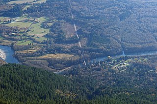
Rockport is a census-designated place (CDP) in Skagit County, Washington, United States. The population was 109 at the 2010 census. It is included in the Mount Vernon–Anacortes, Washington Metropolitan Statistical Area.

Mount Erebus is the second-highest volcano in Antarctica, the highest active volcano in Antarctica, and the southernmost active volcano on Earth. It is the sixth-highest ultra mountain on the continent. With a summit elevation of 3,794 metres (12,448 ft), it is located in the Ross Dependency on Ross Island, which is also home to three inactive volcanoes: Mount Terror, Mount Bird, and Mount Terra Nova.

Mount Bachelor, formerly named Bachelor Butte, is a dormant stratovolcano atop a shield volcano in the Cascade Volcanic Arc and the Cascade Range of central Oregon. Named Mount Bachelor because it stands apart from the nearby Three Sisters, it lies in the eastern segment of the central portion of the High Cascades, the eastern segment of the Cascade Range. The volcano lies at the northern end of the 15-mile (24 km) long Mount Bachelor Volcanic Chain, which underwent four major eruptive episodes during the Pleistocene and the Holocene. The United States Geological Survey considers Mount Bachelor a moderate threat, but Bachelor poses little threat of becoming an active volcano in the near future. It remains unclear whether the volcano is extinct or just inactive.

Ralph Straus Regula was an American politician from Ohio. A member of the Republican Party, he served in the Ohio House of Representatives, the Ohio State Senate and the United States House of Representatives. He represented Ohio's 16th congressional district for 18 terms from 1973 to 2009. In the 110th Congress (2007–2009), he was the second longest serving Republican member of the House of Representatives.

On March 27, 1980, a series of volcanic explosions and pyroclastic flows began at Mount St. Helens in Skamania County, Washington, United States. A series of phreatic blasts occurred from the summit and escalated until a major explosive eruption took place on May 18, 1980, at 8:32 am. The eruption, which had a Volcanic Explosivity Index of 5, was the most significant to occur in the contiguous United States since the much smaller 1915 eruption of Lassen Peak in California. It has often been declared the most disastrous volcanic eruption in U.S. history.

David Alexander Johnston was an American United States Geological Survey (USGS) volcanologist who was killed by the 1980 eruption of Mount St. Helens in the U.S. state of Washington. A principal scientist on the USGS monitoring team, Johnston was killed in the eruption while manning an observation post six miles (10 km) away on the morning of May 18, 1980. He was the first to report the eruption, transmitting "Vancouver! Vancouver! This is it!" before he was swept away by a lateral blast; despite a thorough search, Johnston's body was never found, but state highway workers discovered remnants of his USGS trailer in 1993.

Mount Cleveland is a nearly symmetrical stratovolcano on the western end of Chuginadak Island, which is part of the Islands of Four Mountains just west of Umnak Island in the Fox Islands of the Aleutian Islands of Alaska. Mt. Cleveland is 5,675 ft (1,730 m) high, and one of the most active of the 75 or more volcanoes in the larger Aleutian Arc. Aleutian natives named the island after their fire goddess, Chuginadak, who they believed inhabited the volcano. In 1894 a team from the U.S. Coast and Geodetic Survey visited the island and gave Mount Cleveland its current name, after then-president Grover Cleveland.

Green Mount Cemetery is a historic rural cemetery in Baltimore, Maryland, United States. Established on March 15, 1838, and dedicated on July 13, 1839, it is noted for the large number of historical figures interred in its grounds as well as many prominent Baltimore-area families. It retained the name Green Mount when the land was purchased from the heirs of Baltimore merchant Robert Oliver. Green Mount is a treasury of precious works of art, including striking works by major sculptors including William H. Rinehart and Hans Schuler.

Semisopochnoi Island or Unyak Island is part of the Rat Islands group in the western Aleutian Islands of Alaska. The island is uninhabited and provides an important nesting area for maritime birds. The island is of volcanic origin, containing several volcanoes including Mount Young. It has a land area of 85.558 square miles, measuring 11 miles (18 km) in length and 12 miles (20 km) in width.
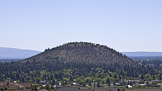
Pilot Butte is a lava dome that was created from an extinct volcano located in Bend, Oregon. It is a cinder cone butte which rises nearly 500 feet (150 m) above the surrounding plains. Bend is one of six cities in the United States to have a volcano within its boundaries. The other examples are Mount Tabor in Portland, Oregon, Jackson Volcano in Jackson, Mississippi, Diamond Head in Honolulu, Glassford Hill in Prescott Valley and Pilot Knob in Austin, Texas.

The U.S. House Committee on Natural Resources or Natural Resources Committee is a Congressional committee of the United States House of Representatives. Originally called the Committee on Interior and Insular Affairs (1951), the name was changed to the Committee on Natural Resources in 1991. The name was shortened to the Committee on Resources in 1995 by the new chairman, Don Young. Following the Democratic takeover of the House of Representatives in 2006, the name of the committee was changed back to its title used between 1991 and 1995.

Florida's 11th congressional district is a congressional district in the U.S. state of Florida. It includes Sumter County, home to The Villages, and parts of Lake, Orange, and Polk counties. In the 2020 redistricting cycle, the district was moved out of its coastal counties and into Orlando's western suburbs.

The Alaska Volcano Observatory (AVO) is a joint program of the United States Geological Survey (USGS), the Geophysical Institute of the University of Alaska Fairbanks (UAFGI), and the State of Alaska Division of Geological and Geophysical Surveys (ADGGS). AVO was formed in 1988, and uses federal, state, and university resources to monitor and study Alaska's volcanology, hazardous volcanoes, to predict and record eruptive activity, and to mitigate volcanic hazards to life and property. The Observatory website allows users to monitor active volcanoes, with seismographs and webcameras that update regularly. AVO now monitors more than 20 volcanoes in Cook Inlet, which is close to Alaskan population centers, and the Aleutian Arc due to the hazard that plumes of ash pose to aviation.

Black Crater is a shield volcano in the Western Cascades in Deschutes County, Oregon. Located near McKenzie Pass, the volcano has a broad conical shape with gentle slopes. The volcano likely formed during the Pleistocene and has not been active within the last 50,000 years. Eruptive activity at the volcano produced mafic lava flows made of basaltic andesite and olivine basalt; it also formed a number of cinder cones. A normal fault occurs on the western side of the volcano, trending north–south. The volcano has been eroded by glaciers, which carved a large cirque into the northeastern flank of the mountain, forming its current crater.

Mount Rainier, also known as Tahoma, is a large active stratovolcano in the Cascade Range of the Pacific Northwest in the United States. The mountain is located in Mount Rainier National Park about 59 miles (95 km) south-southeast of Seattle. With a summit elevation of 14,417 ft (4,394 m), it is the highest mountain in the U.S. state of Washington and the Cascade Range, the most topographically prominent mountain in the contiguous United States, and the tallest in the Cascade Volcanic Arc.

The name of the highest mountain in North America became a subject of dispute in 1975, when the Alaska Legislature asked the U.S. federal government to officially change its name from "Mount McKinley" to "Denali.” The mountain had been unofficially named Mount McKinley in 1896 by a gold prospector, and officially by the federal government in 1917 to commemorate William McKinley, who was President of the United States from 1897 until his assassination in 1901.
