
Monroe County is a county in the Commonwealth of Pennsylvania. As of the 2020 census, the population was 168,327. Its county seat is Stroudsburg. The county is part of the Northeast Pennsylvania region of the state. The county was formed from sections of Northampton and Pike counties on April 1, 1836. It was named in honor of James Monroe, the fifth president of the United States. The county borders Northampton County and the Lehigh Valley to its south, Pike and Wayne counties to its north, Carbon and Luzerne counties to its west, and the Delaware River and Warren County, New Jersey to its east. It is part of the New York metropolitan area, but also receives media from the Scranton/Wilkes-Barre and Philadelphia radio and television markets.
Mount Pocono is a borough in Monroe County, Pennsylvania. The borough serves as a local highway nexus, and sees much tourist traffic making use of resources in the region. As of the 2020 census, the borough population was 3,083 residents.

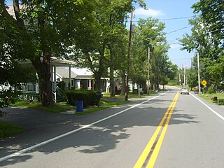
Pocono Pines is a census-designated place (CDP) in Monroe County, Pennsylvania. The population in the 2020 United States Census was 2,007, an increase over the 1,409 population at the 2010 census.
Tobyhanna Township is a township in Monroe County, Pennsylvania, United States. The population was 8,290 at the 2020 census. Tobyhanna Township has Tobyhanna Elementary Center and Locust Lake Village.

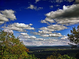
The Pocono Mountains, commonly referred to as the Poconos, are a geographical, geological, and cultural region in Northeastern Pennsylvania. They overlook the Delaware River and Delaware Water Gap to the east, Lake Wallenpaupack to the north, Wyoming Valley and the Coal Region to the west, and the Lehigh Valley to the south. The name Pocono is derived from the Munsee word Pokawachne, which means "Creek Between Two Hills".

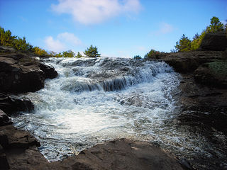
Ricketts Glen State Park is a Pennsylvania state park on 13,193 acres (5,280 ha) in Columbia, Luzerne, and Sullivan counties in Pennsylvania in the United States. Ricketts Glen is a National Natural Landmark known for its old-growth forest and 24 named waterfalls along Kitchen Creek, which flows down the Allegheny Front escarpment from the Allegheny Plateau to the Ridge-and-Valley Appalachians. The park is near the borough of Benton on Pennsylvania Route 118 and Pennsylvania Route 487, and is in five townships: Sugarloaf in Columbia County, Fairmount and Ross in Luzerne County, and Colley and Davidson in Sullivan County.

Pennsylvania Route 940 is a 43.2-mile-long (69.5 km) Pennsylvania highway located in the Pocono Mountains. It runs from PA 309 in Hazleton east to PA 191 in Paradise Valley. Large segments of PA 940 are located in densely forested areas. The route heads northeast through Luzerne County from Hazleton, passing through Freeland and coming to an interchange with Interstate 80 (I-80) in White Haven. From here, PA 940 turns east and runs a short distance north of I-80, coming to an interchange with both I-80 and I-476 in northern Carbon County. The route continues through Monroe County and passes through Pocono Pines before it has an interchange with I-380. PA 940 passes through Mount Pocono prior to continuing to its eastern terminus.
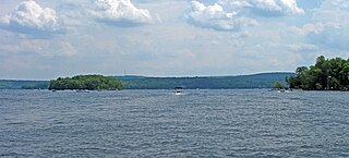
Lake Wallenpaupack is a reservoir in Northeastern Pennsylvania. After Raystown Lake, it is the second-largest lake contained entirely in Pennsylvania. It comprises 52 miles of shoreline, with a length of 13 miles and a maximum depth of 60 feet, and has a surface area in excess of 5,700 acres. It was created in 1926 by the PPL Corporation for hydroelectric purposes as well as flood control; however, it is best known as one of several major recreational destinations in the Pocono Mountains. It is located near the Borough of Hawley, and forms part of the boundary between Pike and Wayne counties. See map.

Pennsylvania Route 715 (PA 715) is a 17.7-mile-long (28.5 km) north–south state route located entirely in Monroe County, Pennsylvania. Its southern terminus is at U.S. Route 209 (US 209) in the Chestnuthill Township hamlet of Brodheadsville. The northern terminus is at PA 191 in the Paradise Township hamlet of Henryville. PA 715 also intersects Interstate 80 (I-80) in Tannersville at Exit 299. The route is a two-lane undivided road running through forested areas of the Pocono Mountains. The road was paved between 1930 and the 1940s. PA 715 was designated to its present alignment in 1963.

Pennsylvania Route 402 is a 29.24-mile (47.06 km) north–south state route in the Pennsylvania counties of Monroe and Pike. The southern terminus of the route is at U.S. Route 209 Business in the Smithfield Township village of Marshalls Creek. The northern terminus is at US 6 in Palmyra Township.

Stillwater Lake is a reservoir that covers approximately 315 acres (1.27 km2). The lake is located in Pocono Summit, Pennsylvania, at an elevation of 1,811 feet (552 m). Fed by Dotter's Run, Hawkeye Run, Pocono Summit Creek, and several underground springs, the lake flows out to Lake Naomi via Tunkhannock Creek. There are several Tunkhannock Creeks in the Pocono Mountains in Northeastern Pennsylvania. This one merges with the Tobyhanna at Pocono Lake. The Tobyhanna flows into the Lehigh, and ultimately into Delaware Bay.
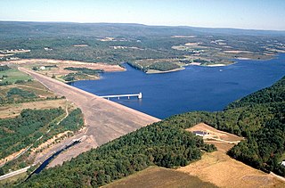
Beltzville State Park is a 2,972.39-acre (1,202.88 ha) Pennsylvania state park in Franklin and Towamensing townships, Carbon County, Pennsylvania in the United States. The park opened in 1972, and was developed around the U.S. Army Corps of Engineers flood control project Beltzville Dam on Pohopoco Creek. The village of Big Creek Valley was vacated in 1966 to make way for Beltzville Lake.

Gouldsboro State Park is a 2,880-acre (1,165 ha) Pennsylvania state park in Coolbaugh Township, Monroe County and Lehigh Township, Wayne County, Pennsylvania in the United States. The park includes the 250-acre (100 ha) Gouldsboro Lake. Gouldsboro State Park is located very close to Tobyhanna State Park and Pennsylvania State Game Lands 127 and 312. It is on Pennsylvania Route 507 near the small village of Gouldsboro.

Pennsylvania Route 903 is a 17.7-mile-long (28.5 km) state highway located in Carbon and Monroe counties in Pennsylvania. The southern terminus is at U.S. Route 209 in Jim Thorpe. The northern terminus is at PA 115 in Tunkhannock Township. The route runs through rural areas of the Pocono Mountains, with an interchange with the Pennsylvania Turnpike Northeast Extension in Penn Forest Township and a junction with PA 534 in Kidder Township. PA 903 is a two-lane undivided road nearly its entire length, besides the I-476 intersection. The route was designated in 1928 between US 209/US 309 in present-day Jim Thorpe, and a connecting road, now PA 115, south of Blakeslee. The highway was fully paved in the 1930s. Between 2008 and 2015, an E-ZPass-only interchange was constructed with I-476.
Woodloch Pines is an all-inclusive resort located in Hawley, Pennsylvania on Lake Teedyuskung in the northeast Pocono Mountains Lake Region. The nearest large city is Scranton, which is 40 miles away. The resort has been owned by the Kiesendahl Family since 1958 and is open all year round. In recent years, Woodloch has expanded to include Woodloch Springs, a championship golf course and housing community, and The Lodge at Woodloch, a destination spa. Woodloch Pines, Woodloch Springs, and The Lodge at Woodloch are all separate resorts.
Tobyhanna is an unincorporated American community that is located in Coolbaugh Township in Monroe County, Pennsylvania. Despite its name, it is not located in Tobyhanna Township.

U.S. Route 209 (US 209) is a 211.74-mile (340.76 km) long U.S. Highway in the states of Pennsylvania and New York. Although the route is a spur of US 9, US 209 never intersects US 9, coming within five miles of the route and making the short connection via New York State Route 199 (NY 199). The southern terminus of the route is at Pennsylvania Route 147 (PA 147) in Millersburg, Pennsylvania. The northern terminus is at US 9W north of Kingston in Ulster, New York, where the road continues east as NY 199.

Penn Hills Resort was a honeymoon resort located in Analomink, Pennsylvania, in the Pocono Mountains. Founded as a tavern in 1944, the resort grew in the 1960s, with over a hundred rooms in the hotel and a ski resort and golf course on the 500-acre site. Guest villas featured floor-to-ceiling carpeting, round beds, and heart-shaped bathtubs. Distinctive, modernist streetlights from the 1964 World's Fair were installed, as well as an ice rink and a wedding bell shaped outdoor swimming pool.
Indian Mountain Lake is a census-designated place (CDP) in Carbon County and Monroe County, Pennsylvania. It is part of Northeastern Pennsylvania.
Lake Naomi is a 277-acre (1.12 km2) lake with private beaches and marinas located in Pocono Pines, Pennsylvania in the Pocono Mountains of Northeastern Pennsylvania. The community of Lake Naomi Club is a resort community that includes 1,400 families who own property surrounding Lake Naomi.


