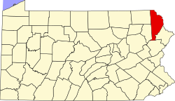
Lake Ariel, Pennsylvania

Last updated

Lake Ariel, Pennsylvania
ViewofLakeAriel1.JPG
Lake Ariel in the autumn.
Nickname: 
Ariel [1]
USA Pennsylvania location map.svg
Red pog.svg
Lake Ariel
Location in Pennsylvania
Usa edcp location map.svg
Red pog.svg
Lake Ariel
Location in United States
Coordinates: 41°27′14″N75°22′58″W / 41.45389°N 75.38278°W / 41.45389; -75.38278
countryUnited States
State Pennsylvania
U.S. Congressional District PA-08
School District Western Wayne
Region II
County Wayne
Magisterial District 22-3-01 [2]
Township Lake
Settled1848 [3]
Founded byMr. Wilcox [3]
Named for Lake Ariel
Elevation
1,434 [4]  ft (437 m)
Time zone UTC-5 (Eastern (EST))
  Summer (DST) UTC-4 (Eastern Daylight (EDT))
ZIP code
18436 [5]
Area code(s) 570 and 272
GNIS feature ID1199892 [4]
FIPS code 42-127-40936 [6] -40944 [4]
Major Roads PA-191.svg PA-296.svg
Waterways Ariel Creek, [7] Lake Ariel, [8] Brooks Lake, [9] Deerfield Lake, [10] Roamingwood Lake, [10] Wildwood Lake [11]
Website Lake Ariel

Lake Ariel is a village in Lake and Salem Townships of Wayne County, Pennsylvania, United States.

Contents

Located in northeastern Pennsylvania, Lake Ariel was founded by settlers with the name of Jones, and was previously known as Jonestown. Following a name change, Lake Ariel became home to Lake Ariel Park, a major tourist destination for Pennsylvanians in the late 19th and early 20th centuries. [12]

History

First settled in 1822 by the Jones family, the town was first called The Stock Farm and later Jonestown or Jones Pond. The first farm was located at the south end of the lake. Although when the village was first settled, it was populated by only a few family farms, Jonestown soon expanded due to the Pennsylvania Coal Company's Gravity Railroad. It brought workers and soon businesses were needed to fulfil their needs, including a post office named Ariel, which would later lead to the change in name of the town.

Lake Ariel Park

Lake Ariel Park was a major destination for many in the late 19th and early 20th centuries. [12]

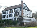
Since the late 19th century through the 20th century, Lake Ariel has had various thriving businesses. There were numerous sawmills, and Lake Ariel also had different factories such as a cheese factory and a chair factory. Many locals also held jobs at the ice houses and Lake Ariel Park. Lake Ariel Park was a major tourist area for the community. It contained a pavilion for picnics and dancing. There were also rides such as a waterslide, a rollercoaster called the Cyclone, carousels, and miniature train rides. The park also had a beach where visitors could go swimming or boating. The owners of Lake Ariel Park also purchased an airplane so that their visitors could pay to get rides in the plane. The Lake Ariel Park also led to the increased popularity of the Lake Ariel Hotel which was formerly known as the Columbia Hotel. The Lake Ariel Hotel stood in disrepair for many years until it was finally torn down in 2011. Unfortunately, the Lake Ariel Park had a worse fate. Due to summer hurricanes and bad winters the park had to be closed down in the early 1950s. Some businesses did withstand the test of time. John T. Howe started his gas station in 1919, the business was passed down to his son and is still in business today. It now is called Howe Convenient Market. It is a gas station and store but it is not in the original building. Another business that had a few changes but is still running today is the Wayne Garage. It was built in 1915, making it the oldest business in Lake Ariel. After it was sold to new owners in 1958 it was changed to a body shop and remains one today.

The original St. Thomas More was dedicated in 1942. In 1996 the construction for the expansion of the church began; the rectory was torn down and rebuilt across the street, the church was converted into a steeple and offices and a new, larger church was built connected to it. A church from the past that remains unchanged today is the Avoy Christian Church, not only is it still standing but it still has services on Sunday. The Gravity Pentecostal Church is also still intact today, but it is now used as a house.

The Lake Ariel Elementary school has gone through many changes in its time. The original building is no longer the educational institute. The building known today as the Lake Ariel Elementary School was formerly known as the Lake Consolidated School. It was built in 1936 and in the 1950s in held the grades kindergarten through 12th. Since a new high school was built in Varden in 1973 it has been used solely as an elementary school. The Lake Ariel Elementary School closed down in 2011, after a new elementary school was built in a nearby town. The building was demolished in mid to late 2016

Present day

The center of Lake Ariel is the setting of most of the community's businesses, although there are numerous others.

Lake Ariel also contains many churches and religious institutions. St. Thomas More's Catholic Church is located in the center of the community, while several Protestant churches are located at various places in the community.

In Lake Ariel, there was the Lake Ariel Elementary School. Children from third to fifth grade attended this school. It was part of the Western Wayne School District which also has schools in the nearby communities of Waymart, Hamlin, and Varden. It was torn down in 2016.

Western Wayne's newest school, Evergreen Elementary, opened August 31, 2011. It is located on Route 191 between Lake Ariel and Hamlin. The school replaced Lake Ariel Elementary and Hamlin Elementary and houses pre-k through fifth grade. According to the Western Wayne School District website the projected cost of the school was $18 million. The new facility is the premier 'green' school in the state. The school attained the Leadership in Energy and Environmental Design Silver Certification for its use of geo-thermal heating and cooling, and solar and wind energy. [13]

Media

WCRV 97.7FM is a low-powered station serving Lake Ariel, Cherry Ridge, and Southern Honesdale.

Related Research Articles

<span class="mw-page-title-main">Wayne County, Pennsylvania</span> County in Pennsylvania

Wayne is a county in the Commonwealth of Pennsylvania. It is part of Northeastern Pennsylvania. The county's population was 51,155 at the 2020 census. The county seat is the Borough of Honesdale. The county was formed from part of Northampton County on March 21, 1798, and was named for the Revolutionary War General Anthony Wayne.

<span class="mw-page-title-main">Canton, Michigan</span> American township in Michigan

Canton, officially the Charter Township of Canton, is a charter township of Wayne County in the U.S. state of Michigan. As of the 2020 census, the township had a population of 98,659.

<span class="mw-page-title-main">Smethport, Pennsylvania</span> Borough in Pennsylvania, United States

Smethport is a borough and county seat of McKean County, Pennsylvania, United States. The mayor is Wayne V. Foltz. The population was 1,430 at the 2020 census. Smethport is part of the Bradford, PA Micropolitan Statistical Area. Smethport, having the coldest temperature ever recorded in Pennsylvania, is the coldest place in Pennsylvania and one of the coldest towns in the contiguous United States.

<span class="mw-page-title-main">Buckingham Township, Wayne County, Pennsylvania</span> Second-class township in Pennsylvania, United States

Buckingham is a second-class township in Wayne County, Pennsylvania, United States. The township's population was 520 at the time of the 2010 United States Census.

<span class="mw-page-title-main">Dreher Township, Wayne County, Pennsylvania</span> Second-class township in Pennsylvania, United States

Dreher is a second-class township in Wayne County, Pennsylvania, United States. The township's population was 1,412 at the time of the 2010 United States Census.

<span class="mw-page-title-main">Honesdale, Pennsylvania</span> Borough in Pennsylvania, United States

Honesdale is a borough in and the county seat of Wayne County, Pennsylvania, United States. The borough's population was 4,458 at the time of the 2020 census.

<span class="mw-page-title-main">Lake Township, Wayne County, Pennsylvania</span> Second-class township in Pennsylvania, United States

Lake is a second-class township in Wayne County, Pennsylvania, United States. The township's population was 5,269 at the time of the 2010 United States Census.

<span class="mw-page-title-main">Preston Township, Wayne County, Pennsylvania</span> Second-class township in Pennsylvania, United States

Preston is a second-class township in Wayne County, Pennsylvania, United States. The township's population was 1,014 at the time of the 2010 United States Census.

<span class="mw-page-title-main">Newfoundland, Pennsylvania</span> Village in Pennsylvania, United States

Newfoundland is a village in Dreher Township, Wayne County, Pennsylvania, United States. It is most famously known as host to the Greene-Dreher-Sterling Fair every Labor Day weekend.

<span class="mw-page-title-main">Orson, Pennsylvania</span> Village in Pennsylvania, United States

Orson is a village in Preston Township, Wayne County, Pennsylvania, United States, situated in the Lake Region of the Poconos. It was once an important depot of the Scranton Division of the New York, Ontario & Western (O&W) Railway, but today, when it is known outside of its immediate vicinity, it is largely for being the site of the intersection of two state roads, Belmont Turnpike and Crosstown Highway, or as the location of Independent Lake Camp (ILC), since ILC's reputation and commercial reach, like those of most rural American summer camps, extend beyond the community in which the camp is physically located.

<span class="mw-page-title-main">Varden Conservation Area</span> State park in Wayne County, Pennsylvania

Varden Conservation Area is a Pennsylvania state park on 343 acres (139 ha) in Lake and South Canaan Townships, Wayne County, Pennsylvania in the United States. The conservation area is currently under development. The land was donated to the Commonwealth of Pennsylvania in December 2001 by Dr. Mead Shaffer a veterinarian and resident of Boothwyn, Pennsylvania in Delaware County. Dr. Shaffer stated his reason for donating the land, "Environmental education always has been a primary concern of mine. I trust this land will allow present and future generations to observe and study the diverse ecology found in the Varden Conservation Area." Varden Conservation Area is near the unincorporated village of Varden on Pennsylvania Route 296, east of the Lackawanna County line.

<span class="mw-page-title-main">Gouldsboro, Pennsylvania</span> Village in Pennsylvania, United States

Gouldsboro is a village and census-designated place (CDP) in Lehigh Township in Wayne County, and Coolbaugh Township, in Monroe County, Pennsylvania, United States. The CDP's population was 750 at time of the 2020 United States Census.

<span class="mw-page-title-main">Pennsylvania Route 196</span> State highway in Pennsylvania, US

Pennsylvania Route 196 is a state highway in the Pocono Mountains of Pennsylvania with a length of 25.7 miles (41.4 km). It runs from PA 611 and PA 940 in Mount Pocono in Monroe County north to PA 296 in Varden in Wayne County. The route is a two-lane undivided road that runs through rural areas. PA 196 intersects PA 423 near Tobyhanna State Park before entering Wayne County, where it crosses PA 507 in Angels and passes through Sterling. The route forms a concurrency with PA 191 and has a junction with PA 590 in Hamlin. Upon splitting from PA 191, PA 196 continues north to its end at PA 296.

<span class="mw-page-title-main">Starlight, Pennsylvania</span> Village in Pennsylvania, United States

Starlight is a village that is located in Buckingham Township, Wayne County, Pennsylvania, United States. Crosstown Highway, which is entirely concurrent with Pennsylvania Route 370 (PA-370), is generally thought to be the southern edge of the village.

<span class="mw-page-title-main">Pennsylvania Route 296</span> State highway in Wayne County, Pennsylvania, US

Pennsylvania Route 296 (PA 296) is a 16.23-mile-long (26.12 km) state highway located in Wayne County, Pennsylvania. The southern terminus is at PA 191 in Lake Ariel. The northern terminus is at PA 247 in Clinton Township. The route is a two-lane undivided road which passes through rural areas. PA 296 heads northwest from PA 191 to Varden, where it intersects the northern terminus of PA 196 and turns to the north. The route continues through Waymart, where it crosses U.S. Route 6 (US 6), before heading north to its end at PA 247 west of Creamton. The portion of PA 296 north of PA 196 follows the Belmont and Easton Turnpike, a turnpike between Belmont and Easton that was chartered in 1812 and completed in 1820. PA 296 was designated on its present routing in the 1930s.

<span class="mw-page-title-main">Western Wayne School District</span> School district in Pennsylvania

Western Wayne School District is a third-class school district in Wayne County, Pennsylvania. The district's population was 19,292 at the time of the 2010 United States Census.

<span class="mw-page-title-main">Poyntelle, Pennsylvania</span> Village in Pennsylvania, United States

Poyntelle is a village that is located in Preston Township, Wayne County, Pennsylvania, United States, in the Lake Region of the Poconos.

Lakeville is a village in Paupack Township, Wayne County, Pennsylvania, United States. It is located along the western shores of Lake Wallenpaupack and can be accessed by Pennsylvania Route 590, about eight miles east of Hamlin, and approximately seven miles west of Hawley, both on Route 590. The city of Scranton is located about 17 miles west.

<span class="mw-page-title-main">Selma, Kansas</span> Unincorporated community in Anderson County, Kansas

Selma is an unincorporated community in Anderson County, Kansas, United States. It is located approximately four miles north-northeast of Kincaid next to a railroad.

<span class="mw-page-title-main">Pleasant Mount, Pennsylvania</span> Unincorporated community in Pennsylvania, United States

Pleasant Mount is an unincorporated community in Mount Pleasant Township, Wayne County, Pennsylvania, United States.

References

  1. White, Israel Charles; Dolph, John M. (1881). The Geology of Susquehanna County and Wayne County (Report). Vol. 23. Board of Commissioners for the Second Geological Survey of Pennsylvania. p. 5. Retrieved December 18, 2014.
  2. "District Magistrate". Wayne County, PA. Wayne County Courthouse. 2014. Archived from the original on November 27, 2014. Retrieved December 18, 2014.
  3. 1 2 Mathews, Alfred (1886). History of Wayne, Pike, and Monroe Counties, Pennsylvania. Philadelphia: R.T. Peck & Company. p.  785 . Retrieved December 18, 2014.
  4. 1 2 3 "Lake Ariel". Geographic Names Information System . United States Geological Survey, United States Department of the Interior. August 2, 1979. Retrieved December 18, 2014.
  5. "Look up a ZIP Code". USPS.COM. USPS. 2014. Retrieved December 18, 2014.
  6. U.S. Census Bureau. Census 2000. "Census Demographic Profiles, Lake Township" (PDF). CenStats Databases. Retrieved January 31, 2009.[ dead link ]
  7. "Ariel Creek". Geographic Names Information System. United States Geological Survey. August 2, 1979. Retrieved December 18, 2014.
  8. "Lake Ariel". Geographic Names Information System. United States Geological Survey. August 2, 1979. Retrieved December 18, 2014.
  9. "Brooks Lake". Geographic Names Information System. United States Geological Survey. August 2, 1979. Retrieved December 18, 2014.
  10. 1 2 "LAKE: SECOND CLASS TOWNSHIP MAP" (PDF). Pennsylvania Department of Transportation. Commonwealth of Pennsylvania. September 10, 1993. Retrieved December 18, 2014.[ permanent dead link ]
  11. "Wildwood Lake". Geographic Names Information System. United States Geological Survey. August 2, 1979. Retrieved December 18, 2014.
  12. 1 2 Lake Ariel Park,
  13. Western Wayne School District Archived 2011-07-28 at the Wayback Machine , .

Further reading