Lakeville, Pennsylvania

Last updated

Lakeville, Pennsylvania
Village of Lakeville
USA Pennsylvania location map.svg
Red pog.svg
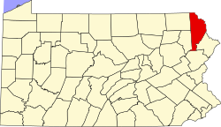
Lakeville
Lakeville's location within Pennsylvania.
Usa edcp location map.svg
Red pog.svg
Lakeville
Lakeville (the United States)
Coordinates: 41°26′17.6″N75°16′35.77″W / 41.438222°N 75.2766028°W / 41.438222; -75.2766028
Country United States
State Pennsylvania
U.S. Congressional District 8
County Wayne
School District Wallenpaupack
Magisterial District 22-3-01 [1]
Township Paupack
Elevation
1,261 ft (384 m)
Population
 (2000)
945 [2]
Time zone UTC-5 (Eastern (EST))
  Summer (DST) UTC-4 (Eastern Daylight (EDT))
ZIP code
18438
Area code(s) 570 and 272
GNIS feature ID1181094 [3]
Major Roads PA Route 590

Lakeville is a village in Paupack Township, Wayne County, Pennsylvania, United States. It is located along the western shores of Lake Wallenpaupack and can be accessed by Pennsylvania Route 590, about eight miles east of Hamlin, and approximately seven miles west of Hawley, both on Route 590. The city of Scranton is located about 17 miles west.

Contents

Attractions and recreation

Capri Marina - A full service and sale marina on Lake Wallenpaupack.

Postal Service

Lakeville formerly had its own post office, but is now served by the Hawley Post Office, as is the rest of Paupack Township. [2]

Related Research Articles

<span class="mw-page-title-main">Wayne County, Pennsylvania</span> County in Pennsylvania

Wayne is a county in the Commonwealth of Pennsylvania. It is part of Northeastern Pennsylvania. The county's population was 51,155 at the 2020 census. The county seat is the Borough of Honesdale. The county was formed from part of Northampton County on March 21, 1798, and was named for the Revolutionary War General Anthony Wayne.

<span class="mw-page-title-main">Pike County, Pennsylvania</span> County in Pennsylvania, United States

Pike County is a county in the Commonwealth of Pennsylvania. It is part of Northeastern Pennsylvania. As of the 2020 census, the population was 58,535. Its county seat is Milford.

<span class="mw-page-title-main">Hawley, Pennsylvania</span> Borough in Pennsylvania, United States

Hawley is a borough on the Lackawaxen River in Wayne County, Pennsylvania, United States. The borough's population was 1,229 at the time of the 2020 United States Census.

<span class="mw-page-title-main">Palmyra Township, Wayne County, Pennsylvania</span> Township in Pennsylvania, United States

Palmyra is a second-class township in Wayne County, Pennsylvania. The township's population was 1,339 at the time of the 2010 United States Census.

<span class="mw-page-title-main">Paupack Township, Pennsylvania</span> Township in Pennsylvania, United States

Paupack is a second-class township in Wayne County, Pennsylvania, United States. The township's population was 3,828 at the time of the 2010 United States Census.

<span class="mw-page-title-main">Newfoundland, Pennsylvania</span> Village in Pennsylvania, United States

Newfoundland is a village in Dreher Township, Wayne County, Pennsylvania, United States. It is most famously known as host to the Greene-Dreher-Sterling Fair every Labor Day weekend.

<span class="mw-page-title-main">Lackawaxen River</span> River in Pennsylvania, United States

The Lackawaxen River is a 31.3-mile-long (50.4 km) tributary of the Delaware River in northeastern Pennsylvania in the United States. The river flows through a largely rural area in the northern Pocono Mountains, draining an area of approximately 598 square miles (1,550 km2).

<span class="mw-page-title-main">The Stourbridge Line</span> Shortline railroad based in Honesdale, Pennsylvania

The Stourbridge Line is a shortline railroad that operates 25 miles (40 km) of former Erie Lackawanna Railroad trackage between Honesdale and Lackawaxen, Pennsylvania, where it connects with Norfolk Southern Railway. The line was previously owned by the Lackawaxen-Honesdale Shippers Association and operated under contract by Robey Railroads. The operation was contracted to the Morristown & Erie Railway in January, 2009; service ended in 2011. Service was resumed by the Delaware, Lackawaxen & Stourbridge Railroad (DL&S) on May 9, 2015.

<span class="mw-page-title-main">Lake Wallenpaupack</span> Reservoir in Pennsylvania, United States

Lake Wallenpaupack is a reservoir in Northeastern Pennsylvania. After Raystown Lake, it is the second-largest lake contained entirely in Pennsylvania. It comprises 52 miles of shoreline, with a length of 13 miles and a maximum depth of 60 feet, and has a surface area in excess of 5,700 acres. It was created in 1926 by the PPL Corporation for hydroelectric purposes as well as flood control; however, it is best known as one of several major recreational destinations in the Pocono Mountains. It is located near the Borough of Hawley, and forms part of the boundary between Pike and Wayne counties. See map.

Greeley is a town in Pike County, Pennsylvania, United States, approximately halfway between Milford and Hawley. Its population is 1322. Lake Greeley Camp is named after this town, and is situated on Lake Greeley.

<span class="mw-page-title-main">Pennsylvania Route 196</span> State highway in Pennsylvania, US

Pennsylvania Route 196 is a state highway in the Pocono Mountains of Pennsylvania with a length of 25.7 miles (41.4 km). It runs from PA 611 and PA 940 in Mount Pocono in Monroe County north to PA 296 in Varden in Wayne County. The route is a two-lane undivided road that runs through rural areas. PA 196 intersects PA 423 near Tobyhanna State Park before entering Wayne County, where it crosses PA 507 in Angels and passes through Sterling. The route forms a concurrency with PA 191 and has a junction with PA 590 in Hamlin. Upon splitting from PA 191, PA 196 continues north to its end at PA 296.

<span class="mw-page-title-main">Pennsylvania Route 348</span> State highway in Pennsylvania, US

Pennsylvania Route 348 (PA 348) is a 7.21-mile-long (11.60 km) state highway located in Lackawanna and Wayne counties in Pennsylvania. The western terminus is at PA 435 near Elmhurst. The eastern terminus is at PA 590 near Hollisterville. PA 348 is a two-lane undivided road that runs through rural areas east of Scranton. From its beginning, the route runs a short distance to the north of Interstate 84 (I-84) before reaching an intersection with PA 247 in Mount Cobb. After this, PA 348 heads farther north from I-84 and leaves Lackawanna County for Wayne County, where it ends at PA 590.

<span class="mw-page-title-main">Pennsylvania Route 390</span> State highway in Monroe and Pike counties in Pennsylvania, United States

Pennsylvania Route 390 is a 25.3-mile-long (40.7 km) state highway located in Monroe and Pike counties in Pennsylvania. The southern terminus is at PA 940 in Paradise Township. The northern terminus is at PA 507 in Tafton View. The route is a two-lane undivided road that runs through forested areas in the Pocono Mountains. PA 390 begins at PA 940 west of Paradise Valley and heads northeast. The route runs concurrent with PA 191 between Cresco and Mountainhome before it splits and intersects PA 447 in Canadensis. PA 390 passes through Skytop before it crosses the county line and runs through Promised Land State Park. The route has an interchange with Interstate 84 (I-84) before passing through Tafton and ending at PA 507 near Lake Wallenpaupack.

<span class="mw-page-title-main">Pennsylvania Route 507</span> State highway in Pennsylvania, US

Pennsylvania Route 507 is a 27.2-mile-long (43.8 km) state highway located in Monroe, Wayne, and Pike counties in Pennsylvania. The southern terminus is at PA 435 and at an interchange with Interstate 380 (I-380) near Gouldsboro. The northern terminus is at U.S. Route 6 in Palmyra Township. PA 507 runs southwest-northeast as a two-lane undivided through forests in the upper reaches of the Pocono Mountains, with the northern section nearly parallel to Lake Wallenpaupack. The route passes through Gouldsboro before it crosses PA 196 in Angels. In Newfoundland, PA 507 and PA 191 run concurrent for about 2 miles (3.2 km) and intersect the north end of PA 447. After splitting from PA 191, the route has an interchange with I-84 and a junction with the northern terminus of PA 390 before ending at US 6. PA 507 was designated between US 611 west of Gouldsboro and US 6 in Tafton in 1928. The route was fully paved by the 1930s and has remained on the same alignment since.

<span class="mw-page-title-main">Pennsylvania Route 590</span> State highway in Pennsylvania, US

Pennsylvania Route 590 is a 45.0-mile-long (72.4 km) state highway located in Lackawanna, Wayne, and Pike counties in Pennsylvania. The western terminus is at PA 435 in Elmhurst Township. The eastern terminus is at PA 434 in the community of Greeley in Lackawaxen Township. PA 590 is mostly a two-lane road that runs through rural areas in Northeastern Pennsylvania. The route serves the communities of Hamlin, Hawley, and Lackawaxen and passes to the north of Lake Wallenpaupack. PA 590 has intersections with PA 690 and PA 348 in Hollisterville, PA 191/PA 196 in Hamlin, and U.S. Route 6 in Hawley.

<span class="mw-page-title-main">Pennsylvania House of Representatives, District 139</span> American legislative district

The 139th Pennsylvania House of Representatives District is located in Northeastern Pennsylvania and has been represented since 2023 by Joseph Adams.

<span class="mw-page-title-main">Wallenpaupack Area School District</span> School district in Pennsylvania

Wallenpaupack Area School District is a third-class school district in Pike and Wayne Counties in Pennsylvania. The district's population was 24,729 at the time of the 2010 United States Census.

Greentown is a village in Greene Township, Pike County, Pennsylvania, United States. It had a population of 4,526 in the 2000 US Census.

<span class="mw-page-title-main">Wallenpaupack Lake Estates, Pennsylvania</span> Place in Pennsylvania, United States

Wallenpaupack Lake Estates is a private community and census-designated place in Paupack Township, Wayne County in the U.S. State of Pennsylvania. The community's population was 1,279 as of the 2010 United States Census.

<span class="mw-page-title-main">Paupack, Pennsylvania</span> Unincorporated community in Pennsylvania, United States

Paupack is an unincorporated community in Pike County, Pennsylvania, United States. The community is 5.5 miles (8.9 km) south of Hawley. Paupack has a post office with ZIP code 18451, which opened on October 19, 1900.

References

  1. "District Magistrate". Wayne County, PA. Wayne County Courthouse. 2014. Archived from the original on November 27, 2014. Retrieved November 14, 2014.
  2. 1 2 "City of Lakeville, PA Zip Codes" . Retrieved April 28, 2015.
  3. "Lakeville". Geographic Names Information System . United States Geological Survey, United States Department of the Interior. August 2, 1979. Retrieved April 28, 2015.