Waymart, Pennsylvania

Last updated
Waymart
House Waymart PA.jpg
House across from Wayside Park
Wayne County Pennsylvania incorporated and unincorporated areas Waymart highlighted.svg
Location in Wayne County and the U.S. state of Pennsylvania.
USA Pennsylvania location map.svg
Red pog.svg
Waymart
Location of Waymart in Pennsylvania
Usa edcp location map.svg
Red pog.svg
Waymart
Waymart (the United States)
Coordinates: 41°34′51″N75°24′25″W / 41.58083°N 75.40694°W / 41.58083; -75.40694 Coordinates: 41°34′51″N75°24′25″W / 41.58083°N 75.40694°W / 41.58083; -75.40694
CountryUnited States
State Pennsylvania
County Wayne
Area
[1]
  Total2.76 sq mi (7.14 km2)
  Land2.69 sq mi (6.97 km2)
  Water0.07 sq mi (0.18 km2)
Elevation
1,873 ft (571 m)
Population
 (2010)
  Total1,341
  Estimate 
(2019) [2]
1,269
  Density471.57/sq mi (182.07/km2)
Time zone UTC-5 (EST)
  Summer (DST) UTC-4 (EDT)
ZIP code
18472
Area code 570
Website Borough website

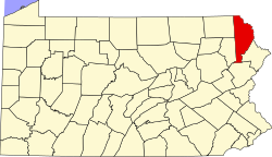
Waymart is a borough in Wayne County, Pennsylvania, United States. The borough's population was 1,341 at the time of the 2010 United States Census. [3]

Contents

Geography

Waymart, PA Waymart, PA.jpg
Waymart, PA

Waymart is located at 41°34′51″N75°24′25″W / 41.58083°N 75.40694°W / 41.58083; -75.40694 (41.580959, -75.406826). [4] Founded as a Borough in 1851. According to the United States Census Bureau, the borough has a total area of 2.8 square miles (7.3 km2), of which 2.7 square miles (7.0 km2) is land and 0.1 square miles (0.26 km2) (3.57%) is water. There is a large lake (Lake Ladore) near the borough.

Demographics

Historical population
CensusPop.
1860 539
1870 5675.2%
1880 503−11.3%
1890 438−12.9%
1900 432−1.4%
1910 412−4.6%
1920 50723.1%
1930 90277.9%
1940 1,09521.4%
1950 1,068−2.5%
1960 1,1063.6%
1970 1,1221.4%
1980 1,24811.2%
1990 1,3377.1%
2000 1,4296.9%
2010 1,341−6.2%
2019 (est.)1,269 [2] −5.4%
Sources: [5] [6] [7]

As of the census [6] of 2000, there were 1,429 people, 492 households, and 344 families residing in the borough. The population density was 516.3 people per square mile (199.2/km2). There were 515 housing units at an average density of 186.1 per square mile (71.8/km2). The racial makeup of the borough was 98.67% White, 0.49% African American, 0.28% Native American, 0.07% from other races, and 0.49% from two or more races. Hispanic or Latino of any race were 1.19% of the population.

There were 492 households, out of which 33.3% had children under the age of 18 living with them, 53.7% were married couples living together, 12.2% had a female householder with no husband present, and 29.9% were non-families. 28.0% of all households were made up of individuals, and 14.0% had someone living alone who was 65 years of age or older. The average household size was 2.56 and the average family size was 3.10.

In the borough the population was spread out, with 24.4% under the age of 18, 5.5% from 18 to 24, 24.4% from 25 to 44, 20.6% from 45 to 64, and 25.1% who were 65 years of age or older. The median age was 42 years. For every 100 females there were 78.8 males. For every 100 females age 18 and over, there were 69.5 males.

The median income for a household in the borough was $35,208, and the median income for a family was $40,417. Males had a median income of $30,395 versus $19,583 for females. The per capita income for the borough was $14,498. About 8.1% of families and 12.3% of the population were below the poverty line, including 11.0% of those under age 18 and 20.7% of those age 65 or over.

Post office USPO Waymart PA 18472.jpg
Post office

Government and infrastructure

The United States Postal Service operates the Waymart Post Office. [8]

The Federal Bureau of Prisons United States Penitentiary, Canaan is in Canaan Township, near Waymart. [9] [10]

The Pennsylvania Department of Corrections runs the State Correctional Institution - Waymart in Waymart.

Related Research Articles

<span class="mw-page-title-main">West Liberty, Pennsylvania</span> Borough in Pennsylvania, United States

West Liberty is a borough in Butler County, Pennsylvania, United States. The population was 343 at the 2010 census.

<span class="mw-page-title-main">East Side, Pennsylvania</span> Borough in Pennsylvania, United States

East Side is a borough in Carbon County, Pennsylvania, United States. The population was 317 at the 2010 census.

<span class="mw-page-title-main">Troutville, Pennsylvania</span> Borough in Pennsylvania, United States

Troutville is a borough in Clearfield County, Pennsylvania, United States. The population was 230 at the 2020 census.

<span class="mw-page-title-main">Jermyn, Pennsylvania</span> Borough in Pennsylvania, United States

Jermyn, known as "The Birthplace of First Aid in America", is a borough in Lackawanna County, Pennsylvania, on the Lackawanna River, 12 miles (19 km) northeast of Scranton. A productive anthracite coal field was in the region in 1900 when 2,567 people lived here. In 1910, 3,158 residents of Jermyn were tallied. In the early years of the twentieth century, coal mines, cut glass works, silk, powder, grist, planing, and saw mills, bottling works, and fertilizer factories dotted the borough. The population was 2,156 at the 2020 census. Jermyn is the mailing address of the Lakeland School District. East Jermyn, the section of town east of the Lackawanna River and west of the small section of Archbald known as "Nebraska", is commonly referred to as "Calico Lane" or "The Lane". Jermyn was incorporated as a borough in 1870 and celebrated its centennial in 1970 with a week-long celebration.

<span class="mw-page-title-main">Mayfield, Pennsylvania</span> Borough in Pennsylvania, United States

Mayfield is a borough in Lackawanna County, Pennsylvania, United States, approximately 14 miles (23 km) northeast of Scranton. In the past, it contained a silk mill and a coal mining industry. The population was 1,763 at the 2020 census.

<span class="mw-page-title-main">Fountain Hill, Pennsylvania</span> Borough in Pennsylvania, United States

Fountain Hill is a borough in Lehigh County, Pennsylvania. The population of Fountain Hill was 4,832 at the 2020 census, an increase from 4,597 at the 2010 census. It is part of the Lehigh Valley metropolitan area, which has a population of 861,899 and is the 68th most populated metropolitan area in the U.S. as of the 2020 census.

<span class="mw-page-title-main">Ashley, Pennsylvania</span> Borough in Pennsylvania, United States

Ashley is a borough in Luzerne County, Pennsylvania, one mile (2 km) from Wilkes Barre. The population was 2,588 at the 2020 census.

<span class="mw-page-title-main">Avoca, Pennsylvania</span> Borough in Pennsylvania, United States

Avoca is a borough within the Greater Pittston area of Luzerne County, Pennsylvania. It is located 7.5 miles (12.1 km) northeast of Wilkes Barre and 3.4 miles (5.5 km) southwest of Scranton. The population was 2,501 at the time of the 2020 census. The Wilkes-Barre/Scranton International Airport (AVP) is located near Avoca.

<span class="mw-page-title-main">Bear Creek Village, Pennsylvania</span> Borough in Pennsylvania, United States

Bear Creek Village is a borough in Luzerne County, Pennsylvania, United States. The population was 290 at the 2020 census.

<span class="mw-page-title-main">Dallas, Pennsylvania</span> Borough in Pennsylvania, United States

Dallas is a borough in Luzerne County, Pennsylvania, United States. The population was 2,692 at the 2020 census. The local government describes the borough as the "Pride" of the Back Mountain. The area includes the townships of Dallas, Franklin, Jackson, Kingston, Lake, and Lehman. The region also includes the boroughs of Dallas and Harveys Lake. Dallas is in the vicinity of Misericordia University and Dallas State Correctional Institution.

<span class="mw-page-title-main">Dupont, Pennsylvania</span> Borough in Pennsylvania, United States

Dupont is a borough in the Greater Pittston area of Luzerne County, Pennsylvania, United States. The population was 2,536 as of the 2020 census.

<span class="mw-page-title-main">Edwardsville, Pennsylvania</span> Borough in Pennsylvania, United States

Edwardsville is a borough in Luzerne County, Pennsylvania, United States. The population was 4,918 at the 2020 census.

<span class="mw-page-title-main">Larksville, Pennsylvania</span> Borough in Pennsylvania, United States

Larksville is a borough in Luzerne County, Pennsylvania, United States. It is 2 miles (3 km) west of Wilkes Barre on the Susquehanna River. The population was 4,216 as of the 2020 census.

<span class="mw-page-title-main">Laurel Run, Pennsylvania</span> Borough in Pennsylvania, United States

Laurel Run is a borough in Luzerne County, Pennsylvania, United States. The population was 560 at the 2020 census.

<span class="mw-page-title-main">Penn Lake Park, Pennsylvania</span> Borough in Pennsylvania, United States

Penn Lake Park is a borough in Luzerne County, Pennsylvania, United States. The population was 359 at the 2020 census.

<span class="mw-page-title-main">Oakland, Susquehanna County, Pennsylvania</span> Borough in Pennsylvania, United States

Oakland is a borough in Susquehanna County, Pennsylvania, United States. The population of Oakland borough was 564 at the 2020 census.

<span class="mw-page-title-main">Thompson, Pennsylvania</span> Borough in Pennsylvania, United States

Thompson is a borough in Susquehanna County, Pennsylvania, United States. The population was 255 at the 2020 census.

<span class="mw-page-title-main">Union Dale, Pennsylvania</span> Borough in Pennsylvania, United States

Union Dale is a borough in Susquehanna County, Pennsylvania, United States. The borough was incorporated in 1885. Union Dale's population was 267 at the 2010 census.

<span class="mw-page-title-main">Canaan Township, Wayne County, Pennsylvania</span> Second-class township in Pennsylvania, United States

Canaan is a second-class township in Wayne County, Pennsylvania, United States. The township's population was 3,963 at the time of the 2010 United States Census.

<span class="mw-page-title-main">Prompton, Pennsylvania</span> Borough in Pennsylvania, United States

Prompton is a borough in Wayne County, Pennsylvania, United States. The population was 250 at the 2010 census.

References

  1. "2019 U.S. Gazetteer Files". United States Census Bureau. Retrieved July 28, 2020.
  2. 1 2 "Population and Housing Unit Estimates". United States Census Bureau. May 24, 2020. Retrieved May 27, 2020.
  3. "U.S. Census website". United States Census Bureau . Retrieved 2011-05-14.
  4. "US Gazetteer files: 2010, 2000, and 1990". United States Census Bureau. 2011-02-12. Retrieved 2011-04-23.
  5. "Census of Population and Housing". U.S. Census Bureau. Retrieved 11 December 2013.
  6. 1 2 "U.S. Census website". United States Census Bureau . Retrieved 2008-01-31.
  7. "Incorporated Places and Minor Civil Divisions Datasets: Subcounty Resident Population Estimates: April 1, 2010 to July 1, 2012". Population Estimates. U.S. Census Bureau. Retrieved 11 December 2013.
  8. "Post Office™ Location - WAYMART." United States Postal Service. Retrieved on February 23, 2011.
  9. "USP Canaan Contact Information Archived 2010-05-27 at the Wayback Machine ." Federal Bureau of Prisons. Retrieved on February 23, 2011. "3057 EASTON TURNPIKE WAYMART, PA 18472."
  10. "Canaan township, Wayne County, Pennsylvania [ permanent dead link ]." U.S. Census Bureau. Retrieved on February 23, 2011.