Mount Pleasant Township, Wayne County, Pennsylvania

Last updated

Mount Pleasant, Pennsylvania
Township of Mount Pleasant
Samuel Meredith Sign at Belmont Corners, Pennsylvania.jpg
A sign in Belmont Corners commemorating Samuel Meredith, the first Treasurer of the United States, and one of the more famous former residents of Mount Pleasant. Claims that Meredith was actually the second treasurer are incorrect as Meredith was the first treasurer to serve under the new U.S. constitution.
Wayne County Pennsylvania incorporated and unincorporated areas Mount Pleasant township highlighted.svg
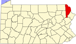
Location in Wayne County and the state of Pennsylvania.
Country United States
State Pennsylvania
US Congressional District PA-8
State Senatorial District 20
State House of Representatives District 111
County Wayne
School District Forest City Regional
Regions V & IV
SettledJune 1789 [1]
Incorporated March 21, 1798
(original township of Wayne County)
Founded bySamuel Stanton [1]
Government
  Type Board of Supervisors
  Board of Supervisors [2]
Supervisors
   US Representative Rob Bresnahan (R)
  State Senator Lisa Baker (R)
  State Representative Sandra Major (R)
Area
[3]
  Total
57.57 sq mi (149.11 km2)
  Land56.46 sq mi (146.22 km2)
  Water1.12 sq mi (2.89 km2)
Elevation
1,427 ft (434.9 m)
Population
 (2010)
  Total
1,357
  Estimate 
(2016) [4]
1,322
  Density23.42/sq mi (9.04/km2)
Time zone UTC-5 (Eastern (EST))
  Summer (DST) UTC-4 (Eastern Daylight (EDT))
Area code 570
GNIS feature ID1217224 [5]
FIPS code 42-127-51872 [6]

Mount Pleasant is a second-class township in Wayne County, Pennsylvania, United States. The township's population was 1,357 at the time of the 2010 United States Census. [7]

Contents

Geography

According to the United States Census Bureau, the township has a total area of 57.6 square miles (149.2 km2), of which 56.5 square miles (146 km2) is land and 1.1 square miles (3 km2) (1.91%) is water.

Communities

The following villages are located in Mount Pleasant Township:

Demographics

Historical population
CensusPop.Note
2010 1,357
2016 (est.)1,322 [4] −2.6%
U.S. Decennial Census [14]

As of the census of 2010, there were 1,357 people, 565 households, and 383 families residing in the township. The population density was 24 people per square mile (9.3/km2). There were 831 housing units at an average density of 14.7/sq mi (5.7/km2). The racial makeup of the township was 97.1% White, 0.7% African American, 0.2% American Indian, 0.9% Asian, 0.5% from other races, and 0.6% from two or more races. Hispanic or Latino of any race were 2.8% of the population.

There were 565 households, out of which 20.9% had children under the age of 18 living with them, 55.6% were married couples living together, 7.4% had a female householder with no husband present, and 32.2% were non-families. 26.4% of all households were made up of individuals, and 12% had someone living alone who was 65 years of age or older. The average household size was 2.40 and the average family size was 2.91.

In the township the population was spread out, with 19.7% under the age of 18, 59.4% from 18 to 64, and 20.9% who were 65 years of age or older. The median age was 48.6 years.

The median income for a household in the township was $53,424, and the median income for a family was $63,100. Males had a median income of $42,250 versus $29,038 for females. The per capita income for the township was $25,987. About 1.5% of families and 1.8% of the population were below the poverty line, including 2.2% of those under age 18 and 1.7% of those age 65 or over.

Education

Forest City Regional School District is a Preschool-12th grade public school district serving residents of Mount Pleasant Township.

Map of Wayne County, Pennsylvania School Districts Map of Wayne County Pennsylvania School Districts.png
Map of Wayne County, Pennsylvania School Districts

References

  1. 1 2 Goodrich, Phineas G. (1992) [1880]. History of Wayne County. Baltimore: Gateway Press, Inc. p. 188.
  2. "Municipal Index" (PDF). Wayne County Planning Commission/GIS. WordPress. 2011. Archived from the original (PDF) on December 3, 2014. Retrieved November 22, 2014.
  3. "2016 U.S. Gazetteer Files". United States Census Bureau. Retrieved August 14, 2017.
  4. 1 2 "Population and Housing Unit Estimates" . Retrieved June 9, 2017.
  5. "Township of Mount Pleasant". Geographic Names Information System . United States Geological Survey, United States Department of the Interior. December 1, 1989. Retrieved November 20, 2014.
  6. U.S. Census Bureau. Census 2000. "Census Demographic Profiles, Mount Pleasant Township" (PDF). CenStats Databases. Retrieved January 31, 2009.[ dead link ]
  7. "U.S. Census website". United States Census Bureau . Retrieved May 14, 2011.
  8. 1 2 3 4 5 6 7 "Mount Pleasant: Second Class Township Map" (PDF). Pennsylvania Department of Transportation (FTP). September 23, 2013. Retrieved November 20, 2014.[dead ftp link](To view documents see Help:FTP)
  9. 1 2 "Belmont Corner". Geographic Names Information System. United States Geological Survey. August 2, 1979. Retrieved November 20, 2014.
  10. "Cascade". Geographic Names Information System. United States Geological Survey. August 30, 1990. Retrieved November 20, 2014.
  11. "Niagara". Geographic Names Information System. United States Geological Survey. December 1, 1989. Retrieved November 20, 2014.
  12. "Rudes Corner". Geographic Names Information System. United States Geological Survey. August 2, 1979. Retrieved November 20, 2014.
  13. "Whites Valley". Geographic Names Information System. United States Geological Survey. August 2, 1979. Retrieved November 20, 2014.
  14. "Census of Population and Housing". Census.gov. Retrieved June 4, 2016.