Wallenpaupack Lake Estates, Pennsylvania

Last updated

Wallenpaupack Lake Estates, Pennsylvania
Wallenpaupack Lake Estates. President - Jerry Beskovoyne, Jr.
Lake-Wallenpaupack.jpg
Wallenpaupack Lake Estates is situated on the banks of Lake Wallenpaupack, the third largest lake in Pennsylvania.
Wayne County Pennsylvania incorporated and unincorporated areas Wallenpaupack Lake Estates highlighted.svg
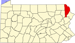
Location in Wayne County and the state of Pennsylvania.
Country United States
State Pennsylvania
US Congressional District PA-10
School District Wallenpaupack Area
County Wayne
Magisterial District 22-3-01 [1]
Township Paupack
Named for Lake Wallenpaupack
Area
  Total2.02 sq mi (5.2 km2)
  Land1.73 sq mi (4 km2)
  Water0.39 sq mi (1 km2)
Elevation
1,371 [2]  ft (418 m)
Population
 (2010)
  Total1,279
  Density285.4/sq mi (739.3/km2)
Time zone UTC-5 (Eastern (EST))
  Summer (DST) UTC-4 (Eastern Daylight (EDT))
ZIP code
Area code(s) 570
GNIS feature IDs2633445, [2] 2633418 [4]
FIPS code 42-127-58480 [5] -80652 [2]
Waterways Beaver Lake, [6] Deer Lake, [7] Lake Wallenpaupack
Website Wallenpaupack Lake Estates

Wallenpaupack Lake Estates is a private community and census-designated place in Paupack Township, Wayne County in the U.S. State of Pennsylvania. The community's population was 1,279 as of the 2010 United States Census.

Contents

Geography

According to the United States Census Bureau, the community has a total area of 2.02 square miles (5.2 km2), 1.73 square miles (4.5 km2) of which is land and 0.39 square miles (1.0 km2) (19.31%) of which is water.

Demographics

As of the census of 2010, there were 1,279 people and 405 families residing in the community. The population density was 739.3 inhabitants per square mile (285.4/km2). There were 1,415 housing units at an average density of 700.5 per square mile (270.5/km2). The racial makeup of the community was 96.0% White, 2.3% Black or African American, 0.2% American Indian or Alaska Native, 0.3% Asian. 0.4% of the community's inhabitants classified themselves as being from other races, and 0.8% identified as two or more races. Hispanics and Latinos of any race made up 3.6% of the population.

There were 537 households, 58.2% of which were heterosexual married couples living together (Pennsylvania did not start performing same-sex marriages until May 20, 2014), and 23.8% of which had children under the age of 18 living with them. 3.4% had a male householder with no wife present, while 11.5% had a female householder with no husband present, and 24.6% of households were non-families. 20.3% of all households were made up of individuals, 9.8% of which consisted of an individual 65 years of age or older. The average household size was 2.38 and the average family size was 2.70.

The community's population was relatively age-diverse, with 18.5% of residents under the age of 18, 54.8% aged 18 to 64, and 26.7% aged 65 years of age or older. The median age was 51.1 years.

The median income for a household in the community was $53,046, and the median income for a family was $64,719. The median income for male full-time, year-round workers was $49,087, while similar females had a median income of $38,635. The per capita income for the community was $28,155. About 11.3% of families and 15.4% of the population were below the poverty threshold, including 21.6% of those under age 18 and 9.4% of those ages 65 or over.

Related Research Articles

<span class="mw-page-title-main">Wayne County, Pennsylvania</span> County in Pennsylvania

Wayne is a county in the Commonwealth of Pennsylvania. It is part of Northeastern Pennsylvania. The county's population was 51,155 at the 2020 census. The county seat is the Borough of Honesdale. The county was formed from part of Northampton County on March 21, 1798, and was named for the Revolutionary War General Anthony Wayne.

<span class="mw-page-title-main">Caledonia Township, Alcona County, Michigan</span> Civil township in Michigan, United States

Caledonia Township is a civil township of Alcona County in the U.S. state of Michigan. The population was 1,161 at the 2010 census.

<span class="mw-page-title-main">Newberg Township, Michigan</span> Civil township in Michigan, United States

Newberg Township is a civil township of Cass County in the U.S. state of Michigan. The population was 1,632 at the 2010 census.

<span class="mw-page-title-main">Lake Fenton, Michigan</span> Census-designated place & unincorporated community in Michigan, United States

Lake Fenton is a census-designated place (CDP) in Fenton Charter Township, Genesee County in the U.S. state of Michigan. As of the 2010 census the population was 5,559, up from 4,876 at the 2000 census. The CDP includes the unincorporated communities of Bayport Park and Lakeside.

<span class="mw-page-title-main">Skandia Township, Michigan</span> Civil township in Michigan, United States

Skandia Township is a civil township of Marquette County in the U.S. state of Michigan. The 2020 census recorded a population of 810 people. The township contains the Dukes Research Natural Area, a National Natural Landmark.

<span class="mw-page-title-main">Wolf Lake, Michigan</span> Census-designated place in Michigan, United States

Wolf Lake is an unincorporated community and census-designated place (CDP) in Muskegon County in the U.S. state of Michigan. At the 2020 census, the population of Wolf Lake was 5,034, up from 4,104 in 2010. As an unincorporated community, Wolf Lake is governed by Egelston Township.

<span class="mw-page-title-main">Addison Township, Michigan</span> Civil township in Michigan, United States

Addison Township is a civil township of northeast Oakland County in the U.S. state of Michigan. As of the 2020 census, the township population was 6,256.

<span class="mw-page-title-main">Lyon Township, Roscommon County, Michigan</span> Civil township in Michigan, United States

Lyon Township is a civil township of Roscommon County in the U.S. state of Michigan. The population was 1,252 at the 2020 census.

<span class="mw-page-title-main">Berlin Township, Wayne County, Pennsylvania</span> Second-class township in Pennsylvania, United States

Berlin Township is a second-class township in Wayne County, Pennsylvania, United States. The township's population was 2,452 at the time of the 2020 United States Census.

<span class="mw-page-title-main">Buckingham Township, Wayne County, Pennsylvania</span> Second-class township in Pennsylvania, United States

Buckingham is a second-class township in Wayne County, Pennsylvania, United States. The township's population was 520 at the time of the 2010 United States Census.

<span class="mw-page-title-main">Canaan Township, Pennsylvania</span> Second-class township in Pennsylvania, United States

Canaan is a second-class township in Wayne County, Pennsylvania, United States. The township's population was 3,963 at the time of the 2010 United States Census.

<span class="mw-page-title-main">Dreher Township, Wayne County, Pennsylvania</span> Second-class township in Pennsylvania, United States

Dreher is a second-class township in Wayne County, Pennsylvania, United States. The township's population was 1,412 at the time of the 2010 United States Census.

<span class="mw-page-title-main">Lake Township, Wayne County, Pennsylvania</span> Second-class township in Pennsylvania, United States

Lake is a second-class township in Wayne County, Pennsylvania, United States. The township's population was 5,269 at the time of the 2010 United States Census.

<span class="mw-page-title-main">Mount Pleasant Township, Wayne County, Pennsylvania</span> Second-class township in Pennsylvania, United States

Mount Pleasant is a second-class township in Wayne County, Pennsylvania, United States. The township's population was 1,357 at the time of the 2010 United States Census.

<span class="mw-page-title-main">Palmyra Township, Wayne County, Pennsylvania</span> Township in Pennsylvania, United States

Palmyra is a second-class township in Wayne County, Pennsylvania. The township's population was 1,339 at the time of the 2010 United States Census.

<span class="mw-page-title-main">Paupack Township, Pennsylvania</span> Township in Pennsylvania, United States

Paupack is a second-class township in Wayne County, Pennsylvania, United States. The township's population was 3,828 at the time of the 2010 United States Census.

<span class="mw-page-title-main">Lake Monticello, Virginia</span> Census-designated place in Virginia, United States

Lake Monticello, a private gated community, is a census-designated place (CDP) in Fluvanna County, Virginia, United States. The population was 10,126 at the 2020 census. The community is centered on a lake of the same name, which is formed by a dam on a short tributary of the nearby Rivanna River. Lake Monticello is part of the Charlottesville Metropolitan Statistical Area. Lake Monticello was developed in the 1960s as a summer vacation home community but quickly evolved into a bedroom community of Charlottesville, and to a smaller extent of Richmond. It also has a sizable retirement age population.

<span class="mw-page-title-main">Russell, Bayfield County, Wisconsin</span> Town in Wisconsin, United States

Russell is a town in Bayfield County, Wisconsin, United States. The population was 1,279 at the 2010 census. The unincorporated communities of Red Cliff and Sand Bay are located in Russell. Red Cliff is the administrative center of the Red Cliff Band of Lake Superior Chippewa. York Island and Raspberry Island are part of the town.

<span class="mw-page-title-main">Gouldsboro, Pennsylvania</span> Village in Pennsylvania, United States

Gouldsboro is a village and census-designated place (CDP) in Lehigh Township in Wayne County, and Coolbaugh Township, in Monroe County, Pennsylvania, United States. The CDP's population was 750 at time of the 2020 United States Census.

<span class="mw-page-title-main">Pocono Springs, Pennsylvania</span> Place in Pennsylvania, United States

Pocono Springs is a private community and census-designated place (CDP) in Lehigh and Sterling Townships in Wayne County, Pennsylvania, United States. The CDP's population was 926 at the time of the 2010 United States Census.

References

  1. "District Magistrate". Wayne County, PA. Wayne County Courthouse. 2014. Archived from the original on November 27, 2014. Retrieved November 14, 2014.
  2. 1 2 3 "Wallenpaupack Lake Estates". Geographic Names Information System . United States Geological Survey, United States Department of the Interior. July 19, 2010. Retrieved December 13, 2014.
  3. "Look up a ZIP Code". USPS.COM. USPS. 2014. Retrieved November 23, 2014.
  4. "Wallenpaupack Lake Estates Census Designated Place". Geographic Names Information System. United States Geological Survey. July 19, 2010. Retrieved December 13, 2014.
  5. U.S. Census Bureau. Census 2000. "Census Demographic Profiles, Paupack Township" (PDF). CenStats Databases. Retrieved December 13, 2014.{{cite web}}: CS1 maint: numeric names: authors list (link)[ dead link ]
  6. "Beaver Lake". Geographic Names Information System. United States Geological Survey. August 30, 1990. Retrieved December 13, 2014.
  7. "Deer Lake". Geographic Names Information System. United States Geological Survey. August 30, 1990. Retrieved December 13, 2014.