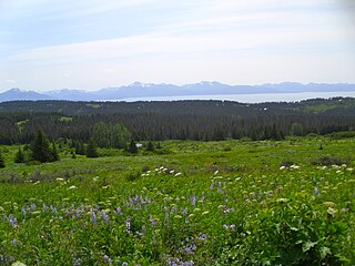
Diamond Ridge is a census-designated place (CDP) just outside Homer in Kenai Peninsula Borough, Alaska, United States. At the 2010 census the population was 1,156, down from 1,802 in 2000.

Yarnell is a census-designated place (CDP) in Yavapai County, Arizona, United States. The population of Yarnell was 649 at the 2010 census. Yarnell's economy is based on ranching, mining and services to travelers and retirees. Peeples Valley, three miles north, is closely linked to Yarnell.

Glenwood is a city in Pike and Montgomery counties in Arkansas, United States. As of the 2020 census, its population was 2,068. The community is located along the Caddo River in the Ouachita Mountains.

Oak Park is an unincorporated community in southeastern Ventura County, California, United States. When developed in the Simi Hills in the late 1960s, a single road provided the only access to the community from Agoura Hills, California, in neighboring Los Angeles County. As of the 2010 census, Oak Park had a population of 14,266, down from 14,625 at the 2000 census. For statistical purposes, the United States Census Bureau has defined Oak Park as a census-designated place (CDP). The census definition of the area may not precisely correspond to local understanding of the area with the same name.

DeBary is a city in Volusia County, Florida, United States, on the eastern shore of the St. Johns River near Lake Monroe. According to the 2020 U.S. Census, the city had a population of 20,696. It is part of the Deltona–Daytona Beach–Ormond Beach, FL metropolitan statistical area, which was home to 553,284 people in 2019.

North Decatur is an unincorporated community and census-designated place (CDP) in DeKalb County, Georgia, United States. The population was 16,698 at the 2010 census.

Darnestown is a United States census-designated place (CDP) and an unincorporated area in Montgomery County, Maryland. The CDP is 17.70 square miles (45.8 km2) with the Potomac River as its southern border and the Muddy Branch as much of its eastern border. Seneca Creek borders portions of its north and west sides. The Travilah, North Potomac, and Germantown census-designated places are adjacent to it, as is the city of Gaithersburg. Land area for the CDP is 16.39 square miles (42.4 km2). As of the 2020 census, the Darnestown CDP had a population of 6,723, while the village of Darnestown is considerably smaller in size and population. Downtown Washington, D.C. is about 22 miles (35 km) to the southeast.

Montgomery Village is a census-designated place (CDP) in Montgomery County, Maryland, United States, and a northern suburb of Washington, D.C. It is a large, planned suburban community, developed in the late 1960s and 1970s just outside Gaithersburg's city limits. Montgomery Village's population was 34,893 at the time of the 2020 U.S. Census, and it is a part of the Washington metropolitan area.

North Potomac is a census-designated place and unincorporated area in Montgomery County, Maryland, United States. It is located less than 5 miles (8.0 km) north of the Potomac River, and is about 20 miles (32 km) from Washington, D.C. It has a population of 23,790 as of 2020.

Chillum is an unincorporated area and census-designated place in Prince George's County, Maryland, United States, bordering Washington, D.C., and Montgomery County.

Lake Mohawk is an unincorporated residential development and census-designated place (CDP) split between Byram Township and Sparta Township, in Sussex County, in the U.S. state of New Jersey. As of the 2010 United States census, the CDP's population was 9,916, of which 1,824 were in Byram Township and 8,092 in Sparta Township.

Blooming Grove is a town in Orange County, New York, United States. The population was 18,811 at the 2020 census. It is located in the central part of the county, southwest of Newburgh.
Smallwood is a hamlet in Sullivan County, New York, United States. The population was 839 at the 2020 census.
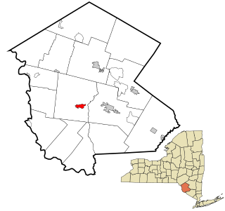
Audubon is a census-designated place (CDP) in Lower Providence Township, Montgomery County, Pennsylvania, United States. It was named for naturalist John James Audubon, who lived there as a young man. The population was 8,433 at the 2010 census.
Seven Oaks is a census-designated place (CDP) in Lexington County, South Carolina, United States, 8 miles (13 km) northwest of downtown Columbia, the state capital. The population of the CDP was 15,144 at the 2010 census. It is part of the Columbia Metropolitan Statistical Area.

South Hill is a census-designated place (CDP) in Pierce County, Washington, immediately south of Puyallup. The population was 64,708 at time of the 2020 census, up from 52,431 in 2010. The area primarily consists of suburban housing and shopping with several retail shopping centers, residential neighborhoods, and apartment/condo complexes throughout. Because South Hill is unincorporated, its addresses are part of the Puyallup "postal city" or ZCTA.
Sugarland Run is a planned community and census-designated place in Loudoun County, Virginia, United States. The population at the 2010 census was 11,799. In 2020, it was estimated to be 12,956. Sugarland Run is part of the Washington metropolitan area and is 26 miles (42 km) by road northwest of Washington, D.C.

Crosspointe is a census-designated place in Fairfax County, Virginia, United States. The population as of the 2020 census was 5,722.

Greenbriar is a census-designated place in Fairfax County, Virginia, United States. The population at the 2020 census was 8,421. The community between Fairfax City and Chantilly dates from the late 1960s, when it was developed by Levitt & Sons. The community is famous for having only one road within its territory that does not start with an "M" or "P", which is Acorn Hill. A popular belief is that the roads were named after the architect's two children. One drawback for residents of the community is that with nearly identical sounding named roads in such close proximity to each other and house numbers being the same, the US Postal Service along with UPS and FedEx sometimes deliver items to the wrong house.

Beaver Dam Lake is a census-designated place (CDP) in the towns of New Windsor, Blooming Grove, and Cornwall in Orange County, New York, United States. As of the 2020 census, it had a population of 2,609.


