Mountain jets are a type of jet stream created by surface winds channeled through mountain passes, sometimes causing high wind speeds and drastic temperature changes.
Chlorophyll growth due to nutrients mixed by 2001 winter jetsMountain jet effects are apparent in average temperatures around Central America
The North Pacific east of about 120°W is strongly influenced by winds blowing through gaps in the Central American cordillera. Air flow in the region forms the Intra-Americas Low-Level Jet, a westward flow about 1km above sea level. This flow, trade winds, and cold air flowing south from North America contribute to winds flowing through several mountain valleys.
The air flow is due to surges of cold dense air originating from the North American continent.
The meteorological mechanism that causes Tehuano and Papagayo winds is relatively simple. In the winter, cold high-pressure weather systems move southward from North America over the Gulf of Mexico. These high pressure systems create strong pressure gradients between the atmosphere over the Gulf of Mexico and the warmer, moister atmosphere over the Pacific Ocean. Just as a river flows from high elevations to lower elevations, the air in the high pressure system will flow "downhill" toward lower pressure, but the Cordillera mountains block the flow of air, channeling it through Chivela Pass in Mexico, the lake district of Nicaragua, and also Gaillard (Culebra) Cut in Panama. Many times, a Tehuano wind is followed by Papagayo and Panama winds a few days later as the high pressure system moves south.
The arrival of these cold surges, and their associated anticyclonic circulation, strengthens the trade winds at low latitudes, and this effect can last for several days. The wind flow over Central America is actually composed of the confluence of two air streams; one from the north, associated with cold surges, and the other from the northeast, associated with trade winds north of South America.
Local effects
The winds blow at speeds of 80km/h or more down the hillsides from Chivela Pass and over the waters of the Gulf of Tehuantepec, sometimes extending more than 500miles (800km) into the Pacific Ocean. The surface waters under the Gulf of Tehuantepec wind jet can cool by as much as 10°C in a day. In addition to the cold water that is detectable from other satellite sensors, the ocean's response to these winds shows up in satellite estimates of chlorophyll from ocean color measurements. The cold water and high chlorophyll concentration are signatures of mixing and upwelling of cold, nutrient-rich deep water. Fish converge on this food source, which supports the highly successful fishing industry in the Gulf of Tehuantepec.
The geography of Mexico describes the geographic features of Mexico, a country in the Americas. Mexico is located at about 23° N and 102° W in the southern portion of North America. From its farthest land points, Mexico is a little over 3,200 km (2,000 mi) in length. Mexico is bounded to the north by the United States, to the west and south by the Pacific Ocean, to the east by the Gulf of Mexico, and to the southeast by Belize, Guatemala, and the Caribbean Sea. The northernmost constituent of Latin America, it is the most populous Spanish-speaking country in the world. Mexico is the world's 13th largest country, three times the size of Texas.
The mistral is a strong, cold, northwesterly wind that blows from southern France into the Gulf of Lion in the northern Mediterranean. It produces sustained winds often exceeding 66 km/h, sometimes reaching 185 km/h. It is most common in the winter and spring, and strongest in the transition between the two seasons. Periods of the wind exceeding 30 km/h for more than sixty-five hours have been reported.
Coatzacoalcos is a major port city in the southern part of the Mexican state of Veracruz, mostly on the western side of the Coatzacoalcos River estuary, on the Bay of Campeche, on the southern Gulf of Mexico coast. The city serves as the municipal seat of the municipality of the same name. It is the state's third largest city, after the city of Veracruz and Xalapa.
The trade winds or easterlies are the permanent east-to-west prevailing winds that flow in the Earth's equatorial region. The trade winds blow mainly from the northeast in the Northern Hemisphere and from the southeast in the Southern Hemisphere, strengthening during the winter and when the Arctic oscillation is in its warm phase. Trade winds have been used by captains of sailing ships to cross the world's oceans for centuries. They enabled colonial expansion into the Americas, and trade routes to become established across the Atlantic Ocean and the Pacific Ocean.
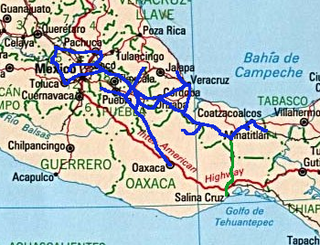
The Isthmus of Tehuantepec is an isthmus in Mexico. It represents the shortest distance between the Gulf of Mexico and the Pacific Ocean. Before the opening of the Panama Canal, it was a major overland transport route known simply as the Tehuantepec Route. The name is taken from the town of Santo Domingo Tehuantepec in the state of Oaxaca; this was derived from the Nahuatl term Tēcuāntepēc.
In meteorology, prevailing wind in a region of the Earth's surface is a surface wind that blows predominantly from a particular direction. The dominant winds are the trends in direction of wind with the highest speed over a particular point on the Earth's surface at any given time. A region's prevailing and dominant winds are the result of global patterns of movement in the Earth's atmosphere. In general, winds are predominantly easterly at low latitudes globally. In the mid-latitudes, westerly winds are dominant, and their strength is largely determined by the polar cyclone. In areas where winds tend to be light, the sea breeze/land breeze cycle is the most important cause of the prevailing wind; in areas which have variable terrain, mountain and valley breezes dominate the wind pattern. Highly elevated surfaces can induce a thermal low, which then augments the environmental wind flow.
The westerlies, anti-trades, or prevailing westerlies, are prevailing winds from the west toward the east in the middle latitudes between 30 and 60 degrees latitude. They originate from the high-pressure areas in the horse latitudes and trend towards the poles and steer extratropical cyclones in this general manner. Tropical cyclones which cross the subtropical ridge axis into the westerlies recurve due to the increased westerly flow. The winds are predominantly from the southwest in the Northern Hemisphere and from the northwest in the Southern Hemisphere.
The 1993 Storm of the Century was a cyclonic storm that formed over the Gulf of Mexico on March 12, 1993. The cold weather, heavy snowfall, high winds and storm surges that the storm brought affected a very large area; at its height, it stretched from Canada to Honduras. The cyclone moved through the Gulf of Mexico and then through the eastern United States before moving on to eastern Canada. It eventually dissipated in the North Atlantic Ocean on March 15.
The 1984 Pacific hurricane season featured numerous tropical cyclones, several of which were impactful to land. It was a busy hurricane season with 21 named storms, 13 hurricanes, and 7 major hurricanes, the latter of which are Category 3 or stronger cyclones on the Saffir–Simpson scale. This activity was unusual given the presence of a La Niña, which typically suppresses Central and East Pacific tropical cyclone activity, and only average sea surface temperatures. Seasonal activity began on May 17 and ended on November 8. This lies within the confines of a traditional hurricane season which begins on May 15 in the East Pacific and June 1 in the Central Pacific, and ends on November 30 in both basins. These dates conventionally delimit the period during each year when most tropical cyclones form.
Tehuantepecer, or Tehuano wind, is a violent mountain-gap wind that travels through the Chivela Pass in southern Mexico, across the Isthmus of Tehuantepec. It is most common between October and February, with a summer minimum in July. It originates from eastern Mexico and the Bay of Campeche as a post-frontal northerly wind, accelerated southward by cold air damming, that crosses the isthmus and blows through the gap between the Mexican and Guatemalan mountains. The term dates back to at least 1929. This wind can reach gale, storm, even hurricane force. The leading edge of its outflow may form rope cloud over the Gulf of Tehuantepec. These winds can be observed on satellite pictures such as scatterometer wind measurements, they influence waves which then propagate as swell and are sometimes observed 1,600 km (1,000 mi) away. These strong winds bring cooler sub-surface waters to the surface of the tropical eastern Pacific Ocean and may last from a few hours to 6 days.
The 1979 Pacific hurricane season was an inactive season, featuring 10 named storms, 6 hurricanes, and 4 major hurricanes. It featured zero tropical cyclones in the Central Pacific, the most recent occurrence on record as of 2021. An average year sees four to five tropical cyclones in that basin.
The Ferrocarril Transístmico, also known as Ferrocarril del Istmo de Tehuantepec, S.A. de C.V. or simply Ferroistmo, is today a railroad with no rolling stock, owned by the Mexican government, that crosses the Isthmus of Tehuantepec between Puerto Mexico, Veracruz, and Salina Cruz, Oaxaca. It is leased to Ferrocarril del Sureste FERROSUR. It was formerly leased to Ferrocarriles Chiapas-Mayab until Genesee & Wyoming gave up its concession in 2007. Originally it was known as the Tehuantepec Railway.
The geography of South America contains many diverse regions and climates. Geographically, South America is generally considered a continent forming the southern portion of the landmass of the Americas, south and east of the Colombia–Panama border by most authorities, or south and east of the Panama Canal by some. South and North America are sometimes considered a single continent or supercontinent, while constituent regions are infrequently considered subcontinents.
North America is the third largest continent, and is also a portion of the third largest supercontinent if North and South America are combined into the Americas and Africa, Europe, and Asia are considered to be part of one supercontinent called Afro-Eurasia. With an estimated population of 580 million and an area of 24,709,000 km2 (9,540,000 mi2), the northernmost of the two continents of the Western Hemisphere is bounded by the Pacific Ocean on the west; the Atlantic Ocean on the east; the Caribbean Sea on the south; and the Arctic Ocean on the north.
Cold air damming, or CAD, is a meteorological phenomenon that involves a high-pressure system (anticyclone) accelerating equatorward east of a north-south oriented mountain range due to the formation of a barrier jet behind a cold front associated with the poleward portion of a split upper level trough. Initially, a high-pressure system moves poleward of a north-south mountain range. Once it sloshes over poleward and eastward of the range, the flow around the high banks up against the mountains, forming a barrier jet which funnels cool air down a stretch of land east of the mountains. The higher the mountain chain, the deeper the cold air mass becomes lodged to its east, and the greater impediment it is within the flow pattern and the more resistant it becomes to intrusions of milder air.
The Chivela Pass is a narrow mountain pass in the Sierra Madre Mountains that funnels cooler, drier air from the North American continent, through southern Mexico, into the Pacific. These northeasterly winds, specifically the Tehuano wind, which periodically blows across the Isthmus of Tehuantepec in southern Mexico, and offshore over hundreds of miles of the Pacific Ocean, forcing the upwelling of colder subsurface waters. This strong upwelling brings nutrients from the subsurface layers of the ocean, thereby enhancing the fertility of the offshore waters. This results in strong plankton growth which in turn supports a more bountiful fishery in the region.
A Gulf of California moisture surge, or simply gulf surge, is a meteorological event where a pulse of high humidity air is pushed up the Gulf of California. Gulf surges bring moisture to southern Arizona during the North American Monsoon. Prior to the 1970s, the consensus of meteorologists was the moisture that fueled the central and southern Arizona monsoon resulted from the movement of the Bermuda High to a more south and west position, which in turn transported water vapor to the region from the Gulf of Mexico. However, operational meteorologists in the 1970s described episodic surges of moisture that infiltrated the area that was thought to originate in the Gulf of California. It was noted that these episodes were likely to be associated with a convective system near the tip of the Baja peninsula such as a tropical cyclone or an easterly wave.
The Sierra Atravesada or Sierra de Niltepec is a mountain range in the state of Oaxaca, Mexico, in the region of the Isthmus of Tehuantepec.
The Papagayo jet, also referred to as the Papagayo Wind or the Papagayo Wind Jet, are strong intermittent winds that blow approximately 70 km north of the Gulf of Papagayo, after which they are named. The jet winds travel southwest from the Caribbean and the Gulf of Mexico to the Pacific Ocean through a pass in the Cordillera mountains at Lake Nicaragua. The jet follows the same path as the northeast trade winds in this region; however, due to a unique combination of synoptic scale meteorology and orographic phenomena, the jet winds can reach much greater speeds than their trade wind counterparts. That is to say, the winds occur when cold high-pressure systems from the North American continent meet warm moist air over the Caribbean and Gulf of Mexico, generating winds that are then funneled through a mountain pass in the Cordillera. The Papagayo jet is also not unique to this region. There are two other breaks in the Cordillera where this same phenomenon occurs, one at the Chivela Pass in México and another at the Panama Canal, producing the Tehuano (Tehuantepecer) and the Panama jets respectively.
This page is based on this Wikipedia article Text is available under the CC BY-SA 4.0 license; additional terms may apply. Images, videos and audio are available under their respective licenses.