Mountains of Kong

Last updated
A map of Africa, made by John Cary in 1805, showing the Mountains of Kong extending eastwards to the Mountains of the Moon. 1805 cary.jpg
A map of Africa, made by John Cary in 1805, showing the Mountains of Kong extending eastwards to the Mountains of the Moon.
The Mountains of Kong on a West African Map from 1839. West Africa 1839 Mitchell map - Kong.jpg
The Mountains of Kong on a West African Map from 1839.

The Mountains of Kong are a legendary mountain range charted on maps of Africa from 1798 through to the late 1880s. [1] The mountains were once thought to begin in West Africa near the highland source of the Niger River close to Tembakounda in Guinea, then continue east to the equally legendary Central African Mountains of the Moon, thought to be where the White Nile had its source. None of these mountains actually exist.

Contents

History

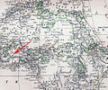
In 1798, a map resulting from the explorations of the area by Mungo Park [2] showed this west-to-east mountain range for the first time. It was produced by the English cartographer James Rennell, [1] who showed the Niger evaporating inland at Wangara. [2] This range was intended to support his own theory on the course of the Niger River, and eventually led to a major impact on the mapping industry to include the mountains. In 1802, Aaron Arrowsmith released a map that included the Mountains of Kong as a main physical geographic feature of western Africa, which encouraged other publishers to update their maps to match. [3]

The German map maker Johann Reinecke included the mountains in his map of 1804 as the Gebirge Kong. [1] In 1805, the London engraver John Cary showed them for the first time linking to the Mountains of the Moon. [1]

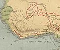
Various nineteenth-century explorers of West Africa included the range on maps they produced or whose production they directed after exploring the area. These include French explorer René Caillié, who explored the highlands of Guinea at Fouta Djallon, near the source of the Niger; the Cornish explorer Richard Lemon Lander and his younger brother John; and Scottish explorer Hugh Clapperton, who also sought the course of the Niger River in its upper reaches. [1] The historians Thomas Basset and Phillip Porter have identified forty maps, published between 1798 and 1892, showing the mountains. [1] [3]

Despite the failure of other later explorers to locate the range, it continued to appear on maps until late in the nineteenth century. [4]

Cartographers began to stop including the mountains on maps after French explorer Louis Gustave Binger established that the mountains were fictitious, in his 1887–89 expedition to chart the Niger River from its mouth in the Gulf of Guinea and through Côte d'Ivoire. [1]

In 1928, Bartholemew's Oxford Advanced Atlas still contained them in its index locating them at 8° 40' N, 5° 0' W. [1] Even later, they appeared erroneously in Goode's World Atlas of 1995. [5]

The town of Kong, Ivory Coast dates to the 12th century and bears the name that it gave to the mountains. This rose in power during the 17th century to form the Kong Empire, which eventually passed under French colonial rule.

Related Research Articles

<span class="mw-page-title-main">Cartography</span> Study and practice of making maps

Cartography is the study and practice of making and using maps. Combining science, aesthetics and technique, cartography builds on the premise that reality can be modeled in ways that communicate spatial information effectively.

<span class="mw-page-title-main">Prince Henry the Navigator</span> Portuguese navigator and Prince (1394–1460)

Dom Henrique of Portugal, Duke of Viseu, better known as Prince Henry the Navigator, was a central figure in the early days of the Portuguese Empire and in the 15th-century European maritime discoveries and maritime expansion. Through his administrative direction, he is regarded as the main initiator of what would be known as the Age of Discovery. Henry was the fourth child of King Dom John I of Portugal, who founded the House of Aviz.

<span class="mw-page-title-main">Niger River</span> Major river in West Africa

The Niger River is the main river of West Africa, extending about 4,180 kilometres. Its drainage basin is 2,117,700 km2 (817,600 sq mi) in area. Its source is in the Guinea Highlands in south-eastern Guinea near the Sierra Leone border. It runs in a crescent shape through Mali, Niger, on the border with Benin and then through Nigeria, discharging through a massive delta, known as the Niger Delta, into the Gulf of Guinea in the Atlantic Ocean. The Niger is the third-longest river in Africa, exceeded by the Nile and the Congo River. Its main tributary is the Benue River.

<span class="mw-page-title-main">Senegal River</span> River in West Africa

The Senegal River is a 1086 km (675 mi) long river in West Africa; much of its length marks part of the border between Senegal and Mauritania. It has a drainage basin of 270000 km2, a mean flow of 680 m3/s (24,000 cu ft/s), and an annual discharge of 21.5 km3 (5.2 cu mi). Important tributaries are the Falémé River, Karakoro River, and the Gorgol River. The river divides into two branches once it passes Kaédi The left branch, called the Doué, runs parallel to the main river to the north. After 200 km (120 mi) the two branches rejoin a few kilometers downstream of Podor.

<span class="mw-page-title-main">Gulf of Guinea</span> Northeasternmost part of the tropical Atlantic Ocean

The Gulf of Guinea is the northeasternmost part of the tropical Atlantic Ocean from Cape Lopez in Gabon, north and west to Cape Palmas in Liberia. Null Island, defined as the intersection of the Equator and Prime Meridian, is in the gulf.

<span class="mw-page-title-main">Geographical exploration</span> Act of traveling and searching for resources or for information about the land or space itself

Geographical exploration, sometimes considered the default meaning for the more general term exploration, refers to the practice of discovering remote lands and regions of the planet Earth. It is studied by geographers and historians.

<span class="mw-page-title-main">Mungo Park (explorer)</span> Scottish naturalist and explorer of the African continent

Mungo Park was a Scottish explorer of West Africa. After an exploration of the upper Niger River around 1796, he wrote a popular and influential travel book titled Travels in the Interior Districts of Africa in which he theorized the Niger and Congo merged to become the same river, though it was later proven that they are different rivers. He was killed during a second expedition, having successfully travelled about two-thirds of the way down the Niger.

<span class="mw-page-title-main">Ogooué River</span> River in Gabon, Africa

The Ogooué, also known as the Nazareth River, some 1,200 kilometres (750 mi) long, is the principal river of Gabon in west-central Africa and the fifth largest river in Africa by volume of discharge, trailing only the Congo, Kasai, Niger and Zambezi. Its watershed drains nearly the entire country of Gabon, with some tributaries reaching into the Republic of the Congo, Cameroon, and Equatorial Guinea.

<span class="mw-page-title-main">Island of California</span> Phantom island

The Island of California refers to a long-held global misconception, dating from the 16th century, that the California region was not part of mainland North America but rather a large island separated from the continent by a strait now known as the Gulf of California.

<span class="mw-page-title-main">Louis-Gustave Binger</span>

Louis-Gustave Binger was a French officer and explorer who claimed the Côte d'Ivoire for France.

<span class="mw-page-title-main">Mountains of the Moon (Africa)</span> Legendary mountain range in east Africa

Mountains of the Moon is a legendary mountain or mountain range in east Africa at the source of the Nile River. Various identifications have been made in modern times, the Rwenzori Mountains of Uganda and the Democratic Republic of the Congo being the most celebrated.

<span class="mw-page-title-main">Fra Mauro map</span> 1450 world map by Italian cartographer Fra Mauro

The Fra Mauro map is a map of the world made around 1450 by the Italian (Venetian) cartographer Fra Mauro, which is “considered the greatest memorial of medieval cartography." It is a circular planisphere drawn on parchment and set in a wooden frame that measures over two by two meters. Including Asia, the Indian Ocean, Africa, Europe, and the Atlantic, it is orientated with south at the top. The map is usually on display in the Biblioteca Nazionale Marciana in Venice in Italy.

<span class="mw-page-title-main">European exploration of Africa</span> Period of history

The geography of North Africa has been reasonably well known among Europeans since classical antiquity in Greco-Roman geography. Northwest Africa was known as either Libya or Africa, while Egypt was considered part of Asia.

The earliest known world maps date to classical antiquity, the oldest examples of the 6th to 5th centuries BCE still based on the flat Earth paradigm. World maps assuming a spherical Earth first appear in the Hellenistic period. The developments of Greek geography during this time, notably by Eratosthenes and Posidonius culminated in the Roman era, with Ptolemy's world map, which would remain authoritative throughout the Middle Ages. Since Ptolemy, knowledge of the approximate size of the Earth allowed cartographers to estimate the extent of their geographical knowledge, and to indicate parts of the planet known to exist but not yet explored as terra incognita.

The history of cartography refers to the development and consequences of cartography, or mapmaking technology, throughout human history. Maps have been one of the most important human inventions for millennia, allowing humans to explain and navigate their way through the world.

The cartography of India begins with early charts for navigation and constructional plans for buildings. Indian traditions influenced Tibetan and Islamic traditions, and in turn, were influenced by the British cartographers who solidified modern concepts into India's map making.

The exploration of North America by European sailors and geographers was an effort by major European powers to map and explore the continent with the goal of economic, religious and military expansion. The combative and rapid nature of this exploration is the result of a series of countering actions by neighboring European nations to ensure no single country had garnered enough wealth and power from the Americas to militarily tip the scales over on the European continent. It spanned the late 15th to early 17th centuries, and consisted primarily of expeditions funded by Spain, England, France, and Portugal. See also the European colonization of the Americas.

<span class="mw-page-title-main">Medici-Laurentian Atlas</span>

The Medici-Laurentian Atlas, also known simply as the Medici Atlas, is an anonymous 14th-century set of maps, probably composed by a Genoese cartographer and explicitly dated 1351, although most historians believe it was composed, or at least retouched, later. The atlas is currently held by the Biblioteca Medicea Laurenziana in Florence, Italy.

<span class="mw-page-title-main">Romans in sub-Saharan Africa</span> Series of expeditions into Africas interior by Roman explorers

Between the first century BC and the fourth century AD, several expeditions and explorations to Lake Chad and western Africa were conducted by groups of military and commercial units of Romans who moved across the Sahara and into the interior of Africa and its coast. However, there was a huge Roman and Greek presence in modern-day Eritrea and Ethiopia. The primary motivation for the expeditions was to secure sources of gold and spices from Axumite piracies.

<i>Africae Tabula Nova</i> Map of Africa published in 1570

Africae Tabula Nova is a map of Africa published by Abraham Ortelius in 1570. It was engraved by Frans Hogenberg and included in Ortelius's 1570 atlas Theatrum Orbis Terrarum, commonly regarded as the first modern atlas. The atlas was printed widely in seven languages and 31 total editions between 1570 and 1612.

References

  1. 1 2 3 4 5 6 7 8 Delaney, John, curator. "Evolution of the Map of Central, East & West Africa". To the Mountains of the Moon: Mapping African Exploration, 1541-1880. Princeton University. Archived from the original on 2008-08-28. Retrieved 2008-08-04.{{cite web}}: CS1 maint: multiple names: authors list (link)
  2. 1 2 Garfield, Simon, On The map, Chapter 11, The Legendary Mountains of Kong, 2012, Profile Books. ISBN   9781846685101
  3. 1 2 Thomas J. Bassett and Philip W. Porter, “From the Best Authorities’: The Mountains of Kong in the Cartography of West Africa,” The Journal of African History 32, No. 1, 1991, 368. doi : 10.1017/S0021853700031522
  4. Stock, Robert (2004). Africa South of the Sahara: A Geographical Interpretation. The Guilford Press. ISBN   1-57230-868-0.
  5. Jennings, Ken (2011). Maphead . Scribner. p.  85. ISBN   978-1-4391-6717-5.