
Newcastle is a small seaside resort town in County Down, Northern Ireland, which had a population of 7,672 at the 2011 Census. It lies by the Irish Sea at the foot of Slieve Donard, the highest of the Mourne Mountains. Newcastle is known for its sandy beach, forests, and mountains. The town lies within the Newry, Mourne and Down District.

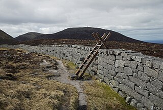
The Mourne Mountains, also called the Mournes or Mountains of Mourne, are a granite mountain range in County Down in the south-east of Northern Ireland. They include the highest mountains in Northern Ireland, the highest of which is Slieve Donard at 850 m (2,790 ft). The Mournes are designated an Area of Outstanding Natural Beauty and it has been proposed to make the area Northern Ireland's first national park. The area is partly owned by the National Trust and sees many visitors every year. The Mourne Wall crosses fifteen of the summits and was built to enclose the catchment basin of the Silent Valley and Ben Crom reservoirs.
The Belfast and County Down Railway (BCDR) was an Irish gauge railway in Ireland linking Belfast with County Down. It was built in the 19th century and absorbed into the Ulster Transport Authority in 1948. All but the line between Belfast and Bangor was closed in the 1950s, although some of it has been restored near Downpatrick by a heritage line, the Downpatrick and County Down Railway.

Slieve Croob is a mountain with a height of 534 metres (1,752 ft) in the middle of County Down, Northern Ireland. It is the heart of a mountainous area known as the Dromara Hills, north of the Mourne Mountains. It is designated an Area of Outstanding Natural Beauty and is the source of the River Lagan. There is a small road to the summit, where there is an ancient burial cairn and several transmitter stations with radio masts. It has wide views over all of County Down and further afield. The Dromara Hills also includes Slievenisky, Cratlieve, Slievegarran and Slievenaboley.

Slieve Donard is the highest mountain in Northern Ireland and the wider province of Ulster, with a height of 850 metres (2,790 ft). The highest of the Mourne Mountains, it is near the town of Newcastle on the eastern coast of County Down, overlooking the Irish Sea. It is also the highest mountain in the northern half of Ireland, and 7th highest on the island.
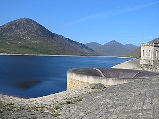
The Silent Valley Reservoir is a reservoir located in the Mourne Mountains near Kilkeel, County Down in Northern Ireland. It supplies most of the water for County Down, surrounding counties and most of Belfast. It is owned and maintained by Northern Ireland Water Limited. The reservoir was built between 1923 and 1933 by a workforce of over 1,000 men, nine of whom died during construction.

Arenig Fawr is a mountain in Snowdonia, North Wales, close to Llyn Celyn reservoir, alongside the A4212 between Trawsfynydd and Bala.

Slieve Binnian is one of the Mourne Mountains in County Down, Northern Ireland, 9 km north of Kilkeel. It is the third-highest mountain in Northern Ireland at 747 metres (2,451 ft). The summit is broad and flat with rocky tors at the north and south ends, with the Back Castles, impressive towers of granite, in between. To the south-west is Wee Binnian (460m). It lies east of Silent Valley Reservoir and west of the Annalong Valley. The Mourne Wall also crosses over Slieve Binnian.
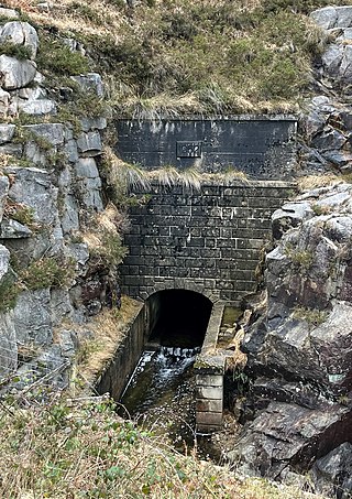
The Binnian Tunnel was constructed between 1947 and 1950/51 and is located under the Mourne Mountains in County Down, Northern Ireland. The main purpose of the tunnel is to divert water from the Annalong Valley to the Silent Valley Reservoir underneath Slieve Binnian, after which the tunnel was named.

Spelga Reservoir is a reservoir in the townland of Spelga in the Mourne Mountains of County Down, Northern Ireland. It was formed by the Spelga Dam and sits at over 1,200 ft (370 m) above sea level. It has a volume of 2,700,000 cubic metres and a catchment area of 5.423 km². It occupies an area known as Deers Meadow, and impounds the River Bann, which rises on the nearby Slieve Muck.

Slieve Commedagh is a mountain with a height of 767 m (2,516 ft) in County Down, Northern Ireland. It is the second-highest of the Mourne Mountains, after Slieve Donard, and the second-highest mountain in Northern Ireland.

Luke Livingstone Macassey was an Irish civil engineer and barrister, notable for his contributions to public health by improving the water supply in the north of Ireland. In 1874 he was appointed consultant hydraulic engineer by the Belfast Water Commissioners in which capacity he was instrumental in finding new sources of water for the expanding city of Belfast. He proposed use of a 9,000-acre catchment area in the Mourne Mountains and a three stage project:
- The first stage was to divert water from the Kilkeel and Annalong rivers through the newly constructed Mourne Conduit to a reservoir at Carryduff. These water pipes were capable of supplying 10 million imperial gallons of water per day. Work was completed in 1901.
- The second stage was to build a storage reservoir, the Silent Valley Reservoir, across the Kilkeel River. Design work on this phase began in 1910, but procurement of the work was delayed by World War I. A contract was eventually awarded in 1923 to S. Pearson & Son and work continued until 1933.
- The third stage was planned to be another storage reservoir in Annalong to impound the Annalong River. However, after the difficulties encountered in building the Silent Valley dam this second dam was not built.
PS Slieve Donard was a United Kingdom passenger paddle steamer that in different periods of her history was also called PS Albion and HMS Albyn. Albion is the name she bore the longest and may be the one by which she is better known in England. Slieve Donard was her original name and the one by which she will be best known on the island of Ireland.

Ben Crom is a 526 metres (1,726 ft) mountain in the Mourne Mountains in County Down, Northern Ireland. It is situated beside Ben Crom Reservoir, which is upstream from Silent Valley Reservoir. The mountain is composed of granite. An exposed area on the south west of the mountain shows where the Eocene aplitic granite meets the laccolith top of the older Mesozoic granite ring dike. The summit of the mountain features granite crags which are crossed by basic and feldspar porphyry dikes. The mountain is used for sheep grazing and hill walking.

Ben Crom Reservoir is a reservoir located in the Mourne Mountains near Kilkeel, County Down, Northern Ireland. Along with Silent Valley Reservoir, which is situated further down the Kilkeel River valley, it supplies water for County Down, surrounding counties and most of Belfast. It was constructed between 1953 and 1957, as the final part of the Mourne scheme to provide water to Belfast which started with the passing of the Belfast Water Act in 1893.

Slieve Meelmore is a mountain located in the Mourne Mountains. It is a popular hiking destination and is just under 6 mile east of the village of Hilltown. The mountain stands at a height of 680 m (2230 ft) and is the 7th highest mountain in Northern Ireland, it is located in the West Mournes with Slieve Meelbeg to the south and Slieve Bearnagh to the east. The Mourne Wall passes over its summit.
The Belfast Water Commissioners was a public body in Ireland and later Northern Ireland, established by the Belfast Water Act 1840, to improve the supply of water to the expanding city of Belfast. By 1852, the city was suffering a shortfall in supply of almost one million gallons per day. In 1889 the body's name was changed to Belfast City and District Water Commissioners in recognition of the expanding boundaries of Belfast and resulting increased demand for water.

Millstone Mountain is a hill in the Mourne Mountains in County Down, Northern Ireland. It is the most easterly peak in the Mournes and, along with Thomas Mountain and Crossone, is one of the three subsidiary peaks of Slieve Donard.
The Mourne Conduit was a water main which ran 42 kilometres (26 mi) from the Silent Valley Reservoir to Carryduff, near Belfast and was built between 1893 and 1901 for the Belfast City and District Water Commissioners. This was supplemented by additional pipelines twice in the 20th Century. This system supplied water to Greater Belfast and North Down for more than 100 years. It is labelled as the Mourne Aqueduct in Ordnance Survey maps from the early 20th century.

Slieve Lamagan or Slievelamagan is one of the Mourne Mountains in County Down, Northern Ireland. It has a height of 702.2 metres (2,304 ft). Slieve Lamagan stands in the middle of the high Eastern Mournes, overlooking Ben Crom Reservoir to the west, Annalong River valley to the east, and Cove Mountain to the northeast. At its southern foot is a small lake called Blue Lough, and a rock formation known as 'Percy Bysshe'.

