
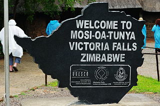
Victoria Falls is a waterfall on the Zambezi River in southern Africa, which provides habitat for several unique species of plants and animals. It is located on the border between Zambia and Zimbabwe and is one of the world's largest waterfalls, with a width of 1,708 m (5,604 ft).

Matabeleland North is a province in western Zimbabwe. With a population of 749,017 as of the 2012 census, it is the country's second-least populous province, after Matabeleland South, and is the country's least densely populated province. Matabeleland North was established in 1974, when the original Matabeleland Province was divided into two provinces, the other being Matabeleland South. In 1997, the province lost territory when the city of Bulawayo became a province in its own ight. Matabeleland North is divided into seven districts. Its capital is Lupane, and Victoria Falls and Hwange its largest towns. The name "Matabeleland" is derived from the Matabele or Ndebele people, the province's largest ethnic group.

Matabeleland South is a province in southwestern Zimbabwe. With a population of 683,893 as of the 2012 Zimbabwean census, it is the country's least populous province. After Matabeleland North, it is Zimbabwe's second-least densely populated province. Matabeleland South was established in 1974, when the original Matabeleland Province was divided into two provinces, the other being Matabeleland North. The province is divided into six districts. Gwanda is the capital, and Beitbridge is the province's largest town. The name "Matabeleland" is derived from Ndebele, the province's largest ethnic group.
Hwange National Park is the largest natural reserve in Zimbabwe. It is around 14,600 sq km in area. It lies in the northwest of the country, just off the main road between Bulawayo and Victoria Falls. The nearest town is Dete. Histories of the region's pre-colonial days and its development as a game reserve and National Park are available online
Kazuma Pan National Park is situated in Zimbabwe's extreme north-western corner, lying on the Botswana border a short distance north-west of Hwange National Park. Some 77,345 acres (313 km²) in area, it provides one of Zimbabwe's few areas of plains scenery, with good visibility and sparse but important mammal populations.
Kalanga, or TjiKalanga, is a Bantu language spoken by the Kalanga people in Botswana and Zimbabwe. It has an extensive phoneme inventory, which includes palatalised, velarised, aspirated and breathy-voiced consonants, as well as whistled sibilants.
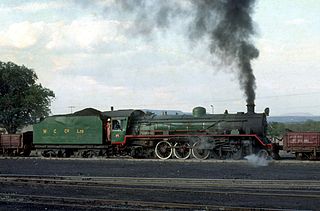
Hwange, originally known as Wankie, is a town in Zimbabwe, located in Hwange District, in Matabeleland North Province, in northwestern Zimbabwe, close to the international borders with Botswana and Zambia. It lies approximately 100 kilometres (62 mi), by road, southeast of Victoria Falls, the nearest large city. The town lies on the railway line from Bulawayo, Zimbabwe's second-largest city, to Victoria Falls. Hwange sits at an elevation of 770 metres (2,530 ft), above sea level.

Victoria Falls, popularly known as Vic Falls, is a resort town and city in the province of Matabeleland North, Zimbabwe. It lies on the southern bank of the Zambezi River at the western end of Victoria Falls themselves. According to the 2022 Population Census, the town had a population of 35,199.
Matetsi is a village in Matabeleland North, Zimbabwe and is located about 55 km west of Hwange. The village started as a railway siding and took its name from the nearby Matetsi River. Most of the surrounding land is under forest and the Matetsi Safari Area. The nearest airports are Victoria Falls (Zimbabwe), Kasane (Botswana), and Livingstone (Zambia)
Plumtree is a town in Zimbabwe. Marula trees, wild plum trees grow abundantly in the area. The town was once called Getjenge by baKalanga. Another name by which it is often caled, is Titji, meaning station and referring to the railway station which was operating in the area around 1897.

Marist Brothers Secondary School, Dete (MBSS), otherwise referred to as 'Marist Dete' is a co-educational (mixed) boarding secondary school Dete, in the Hwange district of Zimbabwe’s Matabeleland North Province. The school was established in 1972 and is part of the international family of Marist schools run by the Marist Brothers, a Catholic society founded in 1817 by Saint Marcellin Champagnat in France.
Hwange Colliery Company Limited is the name of a company in Zimbabwe and of its associated coal mining, processing and marketing. It was founded in 1899. Mining operations are located near Hwange in the province of Matabeleland North. The company's headquarters are in Hwange and registered office the capital Harare and a regional office in Bulawayo.Its stock is listed on the Zimbabwe Stock Exchange and is a component of its stock index, the Zimbabwe Mining Index. It is also listed on the London Stock Exchange and Johannesburg Stock Exchange.
Pandamatenga is a village in the Chobe District, Botswana. It is located close to the country's border with Zimbabwe, whose border post is known as Mpandamatenga.
Zimbabwe Electricity Supply Authority, (ZESA) whose official name is ZESA Holdings (Private) Limited, is a state-owned company whose task is to generate, transmit, and distribute electricity in Zimbabwe. It has organized this task by delegation to its subsidiaries, the energy generating company Zimbabwe Power Company (ZPC) and the Zimbabwe Electricity Transmission and Distribution Company (ZETDC). Other subsidiaries are the investment branch ZESA Enterprises (ZENT) and internet provider PowerTel Communications (Private) Limited. ZESA is the only electricity generator and supplier for the public grid. For many years the company has failed to produce enough energy to meet demands. ZESA produced an estimated 6.8 billion kWh in 2016, while demand was estimated at 7.118 billion kWh. ZESA represents Zimbabwe in the Southern African Power Pool.
Many languages are spoken, or historically have been spoken, in Zimbabwe. Since the adoption of its 2013 Constitution, Zimbabwe has 16 official languages, namely Chewa, Chibarwe, English, Kalanga, Koisan, Nambya, Ndau, Ndebele, Shangani, Shona, sign language, Sotho, Tonga, Tswana, Venda, Xhosa. The country's main languages are Shona, spoken by over 82% of the population, and Ndebele, spoken by roughly 15%. English is the country's lingua franca, used in government and business and as the main medium of instruction in schools. English is the first language of most white Zimbabweans, and is the second language of a majority of black Zimbabweans. Historically, a minority of white Zimbabweans spoke Afrikaans, Greek, Italian, Polish, and Portuguese, among other languages, while Gujarati and Hindi could be found amongst the country's Indian population. Deaf Zimbabweans commonly use one of several varieties of Zimbabwean Sign Language, with some using American Sign Language. Zimbabwean language data is based on estimates, as Zimbabwe has never conducted a census that enumerated people by language.
The Nambya people are an ethnic group of about 100,000 people, based in the north-western parts of Zimbabwe and in the north-eastern parts of Botswana. They are found around the coal mining town of Hwange, surrounding areas of the Victoria Falls as well as in the north-eastern parts of Botswana namely, Pandamatenga, Chobe, Maremaoto, Gweta, Shorobe, Tsienyane, Zoroga, Chumo, Makalamabedi, Sankoyo, Lesoma, Xhumo, Mopipi, Broadhurst, Rakops, Shoshong, Palapye and Maun. Hwange Town and the Hwange National Park were named after the BaNambya King Sawanga, who was later called Hwange by the Nambya people. The Kalanga tribes who were captured by the Nambya warriors from the former Rozvi Empire of the Great Zimbabwe influenced the Nambya language which resulted in the changed pronunciation of words and tone.
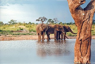
Kavango–Zambezi Transfrontier Conservation Area is the second-largest nature and landscape conservation area in the world, spanning the international borders of five countries in Southern Africa. It includes a major part of the Upper Zambezi River and Okavango basins and Delta, the Caprivi Strip of Namibia, the southeastern part of Angola, southwestern Zambia, the northern wildlands of Botswana and western Zimbabwe. The centre of this area is at the confluence of the Zambezi and Chobe Rivers where the borders of Botswana, Namibia, Zambia and Zimbabwe meet. It incorporates a number of notable national parks and nature sites, including Chobe National Park, Hwange National Park, and the Victoria Falls. The region is home to a population of approximately 250,000 animals, including the largest population of African Elephants in the world.
The Hwange Thermal Power Station is the biggest power plant in Zimbabwe with an installed capacity of 1520 MW. It is owned and operated by the national electricity company Zimbabwe Electricity Supply Authority. It was built in two stages and consists of 4 units of 120 MW each, 2 units of 220 MW each and 2 units of 300 MW each. Engineering Consultants, Merz & McLellan, were employed for the design and supervision of the construction of the power station. Construction of Stage 1 commenced in 1973, but was suspended in 1975 due to economic sanctions imposed on Rhodesia. Stage 1's units were commissioned from 1983 to 1986 with Stage 2's units following in 1986 and 1987.

Hwange District is an administrative district in northwestern Zimbabwe, in southern Africa.
The A8 Highway is a paved primary trunk road in Zimbabwe running from Bulawayo to Victoria Falls. It is managed by the Zimbabwe National Roads Administration (ZINARA). It is part of the R9 Route, which links Victoria Falls with Beitbridge.
