Hwange National Park

Last updated

Hwange National Park
Down the water hole.jpg
African bush elephants in a waterhole of the park
Hwange National Park location.png
The park (in red) on a map of Africa with Zimbabwe highlighted
Location Matabeleland North, Zimbabwe
Nearest city Hwange
Coordinates 18°44′06″S26°57′18″E / 18.735°S 26.955°E / -18.735; 26.955
Area14,651 km2 (5,657 sq mi) [1]
Established1928 as a Game Reserve [2] (1961 as a National Park) [1]
Governing body Zimbabwe Parks and Wildlife Management Authority

Hwange National Park (formerly Wankie Game Reserve) is the largest natural reserve in Zimbabwe. It is around 14,600 sq km in area. It lies in the northwest of the country, just off the main road between Bulawayo and Victoria Falls. The nearest town is Dete. Hwange National Park Airport serves the tourist industry around the National Park. Histories of the region's pre-colonial days and its development as a game reserve and National Park are available online [3] [4] [5]

Contents

History

Hwange National Park was founded in 1928. [2] It is considered for inclusion in the five-nation Kavango - Zambezi Transfrontier Conservation Area. [6]

Poaching incidents

In 2011, nine elephants, five lions and two buffaloes were killed by poachers.[ citation needed ]

In October 2013 it was discovered that poachers killed a large number of African elephants with cyanide after poisoning their waterhole. Conservationists have claimed the incident to be the largest illegal killing of animals in Southern Africa in 25 years. [7] [8] [9] [10] Two aerial surveys were carried to determine the extent of the deaths, and 19 carcasses were identified in the first survey [11] and a further 84 carcasses in the second survey. [12] [13] Three of the poachers were caught, arrested, tried, convicted and sentenced. All royal game and elephant poaching offences now have a mandatory 9-year sentence and the supply chain is also targeted.

Cecil and Xanda hunting incidents

On or about 1 July 2015, Cecil, a lion who had lived on Hwange National Park for 13 years, was killed. [14] This action spurred widespread social media coverage [15] and a petition calling for Zimbabwe's president Robert Mugabe to outlaw big game hunting permits. [16] Walter Palmer, the admitted killer of Cecil, had a permit and was not charged with any crime, as all his papers were in order. [17] Authorities in Zimbabwe have said he is free to visit the country. Charges were initially laid against Theo Bronkhorst, Palmer's guide, for "failing to stop an illegal hunt" but these were later thrown out of court. [18]

Two years after Cecil's killing, his son Xanda met a similar fate. Unlike that of his father, Xanda's killing was not termed illegal, though it did provoke outrage. [19] [20] [21]

Biodiversity

Flora

Game at a pan in a vlei or seasonal wetland Wetland-hwange.jpg
Game at a pan in a vlei or seasonal wetland

The park is close to the edge of the Kalahari desert, a region with little water and very sparse, xerophile vegetation. The Kalahari woodland is dominated by Zambezi Teak, Sand Camwood (Baphia) and Kalahari bauhinia. [22] Seasonal wetlands form grasslands in this area.

The north and north-west of the park are dominated by mopane woodland. [2]

Although it has been argued that elephant populations cause change in vegetation structure, [23] [24] some recent studies suggest that this is not the case, even with the large increases in elephant population recorded in the late 1980s. [25]

Fauna

Lion resting near a termite mound Lion-hwange.jpg
Lion resting near a termite mound

The Park hosts over 100 mammal and 400 bird species, [26] including 19 large herbivores and eight large carnivores. All Zimbabwe's specially protected animals are to be found in Hwange and it is the only protected area where gemsbok and brown hyena occur in small numbers.

Grazing herbivores are more common in the Main Camp Wild Area and Linkwasha Concession Area, with mixed feeders more common in the Robins and Sinamatella Wild Areas, which are more heavily wooded. [27] Distribution fluctuates seasonally, with large herbivores concentrating in areas where intensive water pumping is maintained during the dry season. [28]

The population of the Cape wild dogs to be found in Hwange is thought to be of one of the larger surviving groups in Africa today, along with that of Kruger National Park and Selous Game Reserve. [29] [30]

Other major predators include the lion, whose distribution and hunting in Hwange is strongly related to the pans and waterholes. [31] Since 2005, the protected area is considered a Lion Conservation Unit together with the Okavango Delta. [32]

African leopard, spotted hyena and cheetah are also present in the protected area.[ citation needed ]

Elephant at Longone Pan Eles longone.jpg
Elephant at Longone Pan

Elephants have been enormously successful in Hwange and the population has increased to far above that naturally supported by such an area. [33] This population of elephants has put a lot of strain on the resources of the park. There has been a lot of debate on how to deal with this, with parks authorities implementing culling to reduce populations, [34] especially during 1967 to 1986. The elephant population doubled in the five years following the end of culling in 1986. [35]

National Parks Scientific Services co-ordinates two major conservation and research projects in the park:

Birds

A southern ground hornbill A southern ground hornbill.jpg
A southern ground hornbill

This overview is only one indication of the diversity of birds in the park and is not a complete list.

Geography and geology

Most of the park is underlain by Kalahari Sands. [39] In the north-west there are basalt lava flows of the Batoka Formation, stretching from south of Bumbusi to the Botswana border. [40] [41] [42] In the north-central area, from Sinamatella going eastwards, there are granites and gneisses of the Kamativi-Dete Inlier [43] and smaller inliers of these rocks are found within the basalts in the north-west. [44]

The north and north-west of the park are drained by the Deka and Lukosi rivers and their tributaries, and the far south of the park is drained by the Gwabadzabuya River, a tributary of the Nata River. There are no rivers in the rest of the park, although there are fossil drainage channels in the main camp and Linkwasha areas, which form seasonal wetlands. In these areas without rivers, grassy pan depressions and pans have formed. Some of these pans, such as many of the pans in the Shumba area, fill with rainwater, while others, such as Ngweshla, Shakwanki and Nehimba, are fed by natural groundwater seeps. [45] [46] Many of the pans are additionally supplied by water pumped from underground by park authorities. [47]

Archaeological, historical and cultural sites

People have lived in the region for tens of thousands of years, as attested by numerous archaeological sites ranging from early Stone Age to the historic era. Stone age foragers hunted and gathered in the region, leaving numerous sites with stone tools throughout today's park. They made engravings of animal hoofprints on sandstone rockshelter walls with some small rock paintings in the park's northwest. [48] Iron-age people built large and small stone-walling sites in the park, such Mtoa [49] and the Bumbusi National Monument. [2] Information about the people who once lived in today's park is available online. [50] [51]

Places of interest

Map of Hwange National Park Hwangemap.png
Map of Hwange National Park

Main Camp area

  • Umtshibi camp, the headquarters of the park maintenance unit [47]
  • Mtoa Ruins and Pan
  • Dopi vlei, a fossil river containing Dopi Pan
  • Kennedy vlei, a fossil river also known as Massumamalisa, containing the Kennedy 1, Kennedy 2 (named after Sir John Noble Kennedy, Governor of Southern Rhodesia [47] ) and Massumamalisa (Somalisa) Pans
  • Manga vlei, a fossil river also known as Amanga, containing the Manga Pans
  • Nyamandhlovu Pan (the name refers to elephant meat) and game-viewing platform, one of the most popular game-viewing sites [2]
  • Guvalala Pan and game-viewing platform, rehabilitated by scouts from Kent, UK in the 1990s [52]
  • Dom Pan, where lion are often seen [2]
  • Chivasa Pan
  • Longone Pans, named after the chief cook during the first warden's time [47]
  • Ngweshla Pan, a waterhole heavily frequented by game since before the park's proclamation [2]
  • Shapi Pan, another waterhole heavily frequented by game since before the park's proclamation [2] and former headquarters of the park maintenance unit [47]
  • Sibaya Pan

Sinamatella area

  • Chawato Springs, a mineral spring north-west of Sinamatella on the Bumbusi road [53]
  • Dabashuro (Dobashura) Spring, a mineral spring west of Sinamatella [53]
  • Salt Springs
  • Tshakabika Hot Springs, a thermal spring east of Sinamatella [53]
  • Lukosi River
  • Mandavu Dam and picnic site
  • Masuma Dam, with a thatched shelter overlooking the dam, as well as a camping ground and picnic site [54]
  • New Inyantue Dam
  • Tshompani Dam
  • Dandari (Dandaro) Vlei, Plains and Pan
  • Kapula Vlei
  • Tiriga (Triga) Vlei, a fossil river
  • Shuma Pans, a series of waterholes heavily frequented by game since before the park's proclamation, [2] with a hide and picnic site
  • Nehimba Pan
  • Tshompani Pan

Linkwasha concession area

  • Inkwazi Vlei, a fossil river
  • Makololo Pans and Plains
  • Somavundhla Pan

Dzivanini wilderness area

  • Liputi (Libuti) Camp and well. The name means a meeting place [2]
  • Kordoziba Gate
  • Nata River
  • Gwabazabuya (Gwabadzabuya ) River
  • Limpandi Dam
  • Dzivanini (Sibanini) Pan and mudflats

Shakwanki wilderness area

  • Shakwanki Pan; the name means ear and is a reference to its shape [47]
  • Tamasanka Pan, on the Hunters Road from Tati to Mpandamatenga
  • Xixi Amabandi Pan

Tsamhole wilderness area

  • Tsamhole (Tsamahole) Pan and firetower, on the edge of extensive mudflats. The name refers to a waterhole owned by two people [2]
  • Bumbumutsa Pan; the name means bumble bee [2]
  • Reedbuck vlei, at the headwaters of the Deka River

Accommodation and camping

The park has three large rest camps and four smaller permanent camps. A history of the establishment of the large camps is available online. [55]

Main camp

Nyamandhlovu Pan, near Main Camp Nyamandhlovu-eles.jpg
Nyamandhlovu Pan, near Main Camp

This is the park headquarters, in the north-east, easily accessible by tarred road from the main BulawayoVictoria Falls road. [26]

Camping and picnic sites

Masuma Dam from the hide in the camp Masumadam-eles.jpg
Masuma Dam from the hide in the camp
Shumba Pan from the hide near the camp Shumba-pan.jpg
Shumba Pan from the hide near the camp

In addition, overnight camping is permitted at picnic sites and some of the platforms overlooking waterholes; bookings must be made in advance with the National Parks board. Camping is restricted to one party at a time and during the day, the facilities are open to all visitors. The sites are:

Related Research Articles

<span class="mw-page-title-main">Victoria Falls</span> Waterfall on the Zambezi River in Zambia and Zimbabwe

Victoria Falls is a waterfall on the Zambezi River in southern Africa, which provides habitat for several unique species of plants and animals. It is located on the border between Zambia and Zimbabwe and is one of the world's largest waterfalls, with a width of 1,708 m (5,604 ft).

<span class="mw-page-title-main">Kruger National Park</span> First national park in South Africa

Kruger National Park is a South African National Park and one of the largest game reserves in Africa. It covers an area of 19,623 km2 (7,576 sq mi) in the provinces of Limpopo and Mpumalanga in northeastern South Africa, and extends 360 km (220 mi) from north to south and 65 km (40 mi) from east to west. The administrative headquarters are in Skukuza. Areas of the park were first protected by the government of the South African Republic in 1898, and it became South Africa's first national park in 1926.

<span class="mw-page-title-main">Gonarezhou National Park</span> National park in Zimbabwe

Gonarezhou National Park is a national park located in southeastern Zimbabwe. It is situated in a relatively remote corner of Masvingo Province, south of Chimanimani along the Mozambique border. Owing to its vast size, rugged terrain and its location away from main tourist routes, large tracts of Gonarezhou remain pristine wilderness.

Matusadona National Park is a national park in northern Zimbabwe situated on the southern shore of Lake Kariba. The park takes its name from the local Matuzviadonha Hills.

<span class="mw-page-title-main">Zimbabwe Parks and Wildlife Management Authority</span>

Zimbabwe Parks and Wildlife Management Authority (Zimparks) is an agency of the Zimbabwe government managing national parks. Zimbabwe's game reserves are managed by the government. They were initially founded as a means of using unproductive land.

<span class="mw-page-title-main">Nyanga National Park</span> National park in Zimbabwe

Nyanga National Park lies in the north of Zimbabwe's Eastern Highlands. One of the first national parks to be declared in the country, it contains the highest land in Zimbabwe, with green hills and perennial rivers. Most of its terrain consists of rolling downland, sometimes lightly wooded, lying at altitudes between 1,800–2,593 metres. Mount Nyangani, the highest point in Zimbabwe, lies in the centre of the park and Mutarazi Falls, Zimbabwe's highest waterfall, is in the south of the park. Nyanga National Park incorporates the former Mutarazi Falls National Park on its southern boundary.

<span class="mw-page-title-main">Matobo National Park</span> National park in Zimbabwe

The Matobo National Park forms the core of the Matobo or Matopos Hills, an area of granite kopjes and wooded valleys commencing some 35 kilometres (22 mi) south of Bulawayo, southern Zimbabwe. The hills were formed over 2 billion years ago with granite being forced to the surface; it has eroded to produce smooth "whaleback dwalas" and broken kopjes, strewn with boulders and interspersed with thickets of vegetation. Matopo/Matob was named by the Lozwi, who are the ancestors of Kalanga. A different tradition states that the first King, Mzilikazi Khumalo when told by the local residents that the great granite domes were called madombo he replied, possible half jest, "We will call them matobo" - an IsiNdebele play on 'Bald heads'.

Kazuma Pan National Park is situated in Zimbabwe's extreme north-western corner, lying on the Botswana border a short distance north-west of Hwange National Park. Some 77,345 acres (313 km²) in area, it provides one of Zimbabwe's few areas of plains scenery, with good visibility and sparse but important mammal populations.

Hwange, originally known as Wankie, is a town in Zimbabwe, located in Hwange District, in Matabeleland North Province, in northwestern Zimbabwe, close to the international borders with Botswana and Zambia. It lies approximately 100 kilometres (62 mi), by road, southeast of Victoria Falls, the nearest large city. The town lies on the railway line from Bulawayo, Zimbabwe's second-largest city, to Victoria Falls. Hwange sits at an elevation of 770 metres (2,530 ft), above sea level.

<span class="mw-page-title-main">Great Limpopo Transfrontier Park</span> Transfrontier park in South Africa, Mozambique qnd Zimbabwe

Great Limpopo Transfrontier Park is a 35,000 km² peace park that is in the process of being formed. It will link the Limpopo National Park in Mozambique, Kruger National Park in South Africa, Gonarezhou National Park, Manjinji Pan Sanctuary and Malipati Safari Area in Zimbabwe, as well as the area between Kruger and Gonarezhou, the Sengwe communal land in Zimbabwe and the Makuleke region in South Africa.

<span class="mw-page-title-main">Tsholotsho District</span> Administrative district in Matabeleland North, Zimbabwe

Tsholotsho, originally known as Tjolotjo, is a district in Matabeleland North province in Zimbabwe. Its administrative centre is at Tsholotsho business centre which is located about 98 km north-west of Bulawayo. Districts around Tsholotsho include Lupane, Hwange, Umguza, and Bulilima. The Manzamnyama River separates Tsholotsho from Bulilima District, whilst the Gwayi River separates it from Umguza and Lupane districts, and the Hwange National Park separates it from Hwange District.

Dete is a small railway re-crewing depot and a developing town on the Bulawayo-Hwange-Victoria Falls railway line in Zimbabwe, approximately 300 km (190 mi) north-west of Bulawayo and 67 km (42 mi) south-east of Hwange, lying within the Hwange National Park.

<i>Panthera leo melanochaita</i> Lion subspecies

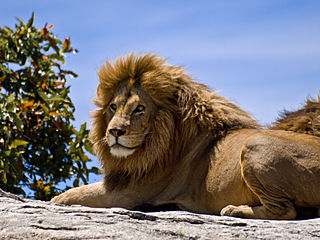
Panthera leo melanochaita is a lion subspecies in Southern and East Africa. In this part of Africa, lion populations are regionally extinct in Lesotho, Djibouti and Eritrea, and are threatened by loss of habitat and prey base, killing by local people in retaliation for loss of livestock, and in several countries also by trophy hunting. Since the turn of the 21st century, lion populations in intensively managed protected areas in Botswana, Namibia, South Africa and Zimbabwe have increased, but declined in East African range countries. In 2005, a Lion Conservation Strategy was developed for East and Southern Africa.

<span class="mw-page-title-main">Wildlife of Zimbabwe</span> Native fauna and flora of Zimbabwe

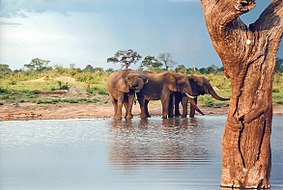
The wildlife of Zimbabwe occurs foremost in remote or rugged terrain, in national parks and private wildlife ranches, in miombo woodlands and thorny acacia or kopje. The prominent wild fauna includes African buffalo, African bush elephant, black rhinoceros, southern giraffe, African leopard, lion, plains zebra, and several antelope species.

<span class="mw-page-title-main">Thuli Parks and Wildlife Land</span> Protected area in Zimbabwe

Thuli Parks and Wildlife Land is a protected area in south-western Zimbabwe. It comprises four areas within the Zimbabwe Parks and Wildlife Estate and covers the entire west bank of the Shashe River within the Thuli Circle.

Bumbusi is a Zimbabwean archaeological site, surrounded by Hwange National Park, in Western Zimbabwe. It is not often visited because of its remote location and low tourist profile. The remains on the site resemble those of other archaeological sites in the Great Zimbabwe tradition. The Bumbusi National Monument consists of colossal stone walls, boulders, platforms and the ruins of dwellings. Its main structures date from the eighteenth and nineteenth century. Excavations in 2000 revealed the floors of eighteen original dwellings. The site was declared a National Monument in 1946. In 2008 it was listed in the World Monuments Watch List of 100 of Most Endangered Sites by the World Monuments Fund because of the threats posed to the sandstone walls by wild animals from the surrounding nature reserve.

Kavango–Zambezi Transfrontier Conservation Area is the second-largest nature and landscape conservation area in the world, spanning the international borders of five countries in Southern Africa. It includes a major part of the Upper Zambezi River and Okavango basins and Delta, the Caprivi Strip of Namibia, the southeastern part of Angola, southwestern Zambia, the northern wildlands of Botswana and western Zimbabwe. The centre of this area is at the confluence of the Zambezi and Chobe Rivers where the borders of Botswana, Namibia, Zambia and Zimbabwe meet. It incorporates a number of notable national parks and nature sites, including Chobe National Park, Hwange National Park, and the Victoria Falls. The region is home to a population of approximately 250,000 animals, including the largest population of African Elephants in the world.

The Kruger National Park is a South African National Park and one of the largest game reserves in Africa. Originally known as The Sabi Game Reserve, it became a game reserve in 1898. The park became known as Kruger National Park in 1926, when it was named after Paul Kruger.

<span class="mw-page-title-main">Killing of Cecil the lion</span> Lion that lived in the Hwange National Park

Cecil was a male African lion who lived primarily in the Hwange National Park in Matabeleland North, Zimbabwe. He was being studied and tracked by a research team of the University of Oxford as part of a long-term study.

<span class="mw-page-title-main">Species affected by poaching</span>

Many species are affected by poaching, including illegal hunting, fishing and capturing of wild animals, and, in a recent usage, the illegal harvesting of wild plant species. The article provides an overview of species currently endangered or impaired by poaching in the Americas, sub-Saharan Africa, and South-East Asia.

References

  1. 1 2 National Parks and Nature Reserves of Zimbabwe, World Institute for Conservation and Environment Archived 16 April 2012 at the Wayback Machine .
  2. 1 2 3 4 5 6 7 8 9 10 11 12 G. Child; B. Reese (1977). Wankie National Park. National Parks and Wildlife Management of Rhodesia.
  3. Haynes, G.; Klimowicz, J. (2020). Hwange National Park's Historic and Pre-Historic Places (Report). Unpublished. doi:10.13140/RG.2.2.31002.06086.
  4. Haynes, G. (2020). "The Forest with a Desert Heart". Hwange National Park: The Forest with a Desert Heart (Report). doi:10.13140/RG.2.2.19784.55043.
  5. Haynes, G. (2020). "Colonial Days; Ted Davison Makes A Great Game Reserve". Hwange National Park: The Forest with a Desert Heart (Report). doi:10.13140/RG.2.2.23441.45922.
  6. "Hwange National Park". Venture To Zimbabwe. Retrieved 22 June 2022.
  7. "Zimbabwe elephants poisoned by poachers in Hwange". BBC News. 6 September 2013. Retrieved 25 September 2013.
  8. Death by cyanide: poachers kill 40 elephants in Zimbabwe as China drives ivory demand
  9. "Poachers kill 300 Zimbabwe elephants with cyanide". Telegraph.co.uk. Retrieved 27 November 2013.
  10. "Zimbabwe elephants poisoned by cyanide". BBC News. 24 September 2013. Retrieved 25 September 2013.
  11. Colin Gillies (November 2013). Report on Hwange Elephant Poisoning (Report). Matabeleland Branch, Wildlife and Environment Zimbabwe.
  12. Colin Gillies (November 2013). 2nd Report Hwange Elephant Poisoning (Report). Matabeleland Branch, Wildlife and Environment Zimbabwe.
  13. Zimbabwe elephants poisoned by poachers in Hwange
  14. "Zimbabwe hunter loses bid to have Cecil case dropped". Yahoo! News . 20 October 2015.
  15. "Cecil the Lion's Death Prompts Social Media Outcry - US News". U.S. News & World Report . Retrieved 30 July 2015.
  16. "How the internet descended on the man who killed Cecil the lion - BBC News". BBC Online . Retrieved 30 July 2015.
  17. "Zimbabwe will not charge U.S. Dentist for killing Cecil the lion". 12 October 2015.
  18. Bale, Rachael (11 November 2016). "Cecil the Lion: Charges Dropped Against Professional Hunter". National Geographic . Archived from the original on 12 November 2016. Retrieved 5 May 2017.
  19. "Xanda, son of Cecil the lion, killed by hunter in Zimbabwe". BBC News. 20 July 2017. Retrieved 20 July 2017.
  20. Bever, L.; Brulliard, K. (20 July 2017). "Cecil the lion's son has 'met the same fate' — killed in a trophy hunt in Zimbabwe, reports say". Washington Post . Retrieved 20 July 2017.
  21. Damian Carrington (20 July 2017). "Son of Cecil the lion killed by trophy hunter". The Guardian . Retrieved 20 July 2017.
  22. M.A. Hyde; B.T. Wursten; P. Ballings (2010). "Flora of Zimbabwe: Outing no. 6: Visit to Hwange National Park and Bulawayo" . Retrieved 27 January 2012.
  23. Holdo, R.M. (2007). "Elephants, Fire, and Frost Can Determine Community Structure and Composition in Kalahari Woodlands" (PDF). Ecological Applications. 17 (2): 558–68. doi:10.1890/05-1990. PMID   17489259. Archived from the original (PDF) on 27 June 2010.
  24. Cumming, D.H.M., Fenton, M.B., Rautenbach, I.L., Taylor, R.D., Cumming, G.S., Cumming, M.S., Dunlop, J.M., Ford, G.S., Hovorka, M.D., Johnston, D.S., Kalcounis, M.C., Mahlanga, Z., and C.V. Portfors (1997). "Elephants, woodlands and biodiversity in southern Africa". South African Journal of Science. 93: 231–236. Archived from the original on 26 November 2016.{{cite journal}}: CS1 maint: multiple names: authors list (link)
  25. Valeix, Marion; Fritz, Hervé; Dubois, Ségolène; Kanengoni, Kwanele; Alleaume, Samuel; Saïd, Sonia (2007). "Vegetation structure and ungulate abundance over a period of increasing elephant abundance in Hwange National Park, Zimbabwe". Journal of Tropical Ecology. 23: 87. doi:10.1017/S0266467406003609. S2CID   55750086.
  26. 1 2 3 "Hwange National Park". Parks and Wildlife Management Authority. Archived from the original on 21 March 2012. Retrieved 26 January 2012.
  27. Chamaillé-Jammes, Simon; Valeix, Marion; Bourgarel, Mathieu; Murindagomo, Felix; Fritz, Hervé (2009). "Seasonal density estimates of common large herbivores in Hwange National Park, Zimbabwe" (PDF). African Journal of Ecology. 47 (4): 804–808. doi:10.1111/j.1365-2028.2009.01077.x. hdl: 11427/28050 . Archived from the original (PDF) on 13 March 2022.
  28. Valeix, Marion (2011). "Temporal dynamics of dry-season water-hole use by large African herbivores in two years of contrasting rainfall in Hwange National Park, Zimbabwe". Journal of Tropical Ecology. 27 (2): 163. doi:10.1017/S0266467410000647. S2CID   85918271.
  29. Woodroffe, Rosie; Ginsberg, Joshua R. (1999). "Conserving the African wild dog Lycaon pictus. I. Diagnosing and treating causes of decline". Oryx. 33 (2): 132. doi: 10.1046/j.1365-3008.1999.00052.x .
  30. Girman, D. J.; Vilà, C.; Geffen, E.; Creel, S.; Mills, M. G. L.; McNutt, J. W.; Ginsberg, J.; Kat, P. W.; et al. (2001). "Patterns of population subdivision, gene flow and genetic variability in the African wild dog (Lycaon pictus)" (PDF). Molecular Ecology. 10 (7): 1703–23. doi:10.1046/j.0962-1083.2001.01302.x. PMID   11472538. S2CID   24540274.
  31. Valeix, M.; Loveridge, A.J.; Davidson, Z.; Madzikanda, H.; Fritz, H.; MacDonald, D.W. (2009). "How key habitat features influence large terrestrial carnivore movements: Waterholes and African lions in a semi-arid savanna of north-western Zimbabwe". Landscape Ecology. 25 (3): 337−351. doi:10.1007/s10980-009-9425-x. S2CID   24083943.
  32. IUCN Cat Specialist Group (2006). Conservation Strategy for the Lion Panthera leo in Eastern and Southern Africa. IUCN, Pretoria, South Africa.
  33. B. Williamson (1975). "Seasonal distribution of elephant in Wankie National Park". Arnoldia.
  34. G. Child (2004). "Elephant Culling in Zimbabwe". Zimconservation Opinion. 1: 1–6. Archived from the original on 10 August 2014.
  35. Chamaillé-Jammes, Simon; Fritz, Hervé; Holdo, Ricardo M. (2007). "Spatial relationship between elephant and sodium concentration of water disappears as density increases in Hwange National Park, Zimbabwe" (PDF). Journal of Tropical Ecology. 23 (6): 725–728. doi:10.1017/S0266467407004531. S2CID   85577974. Archived from the original (PDF) on 27 June 2010.
  36. "Zimbabwe National Leopard Survey" (PDF). Zimbabwe Parks and Wildlife Management Authority. Retrieved 10 June 2013.[ permanent dead link ]
  37. "Painted Dog Conservation Organisation: – End of Year Report 2011" (PDF). Zimbabwe Parks and Wildlife Management Authority. Retrieved 10 June 2013.[ permanent dead link ]
  38. 1 2 3 "Hwange National Park in Zimbabwe, October 2017". Independent Travellers. independent-travellers.com. Retrieved 11 April 2018.
  39. J.C.Ferguson (1938). Geological reconnaissance in the Wankie Game Reserve (Report). Zimbabwe Geological Survey Technical Files.
  40. B.Lightfoot (1912). "The Geology of the North-Western Part of the Wankie Coalfield, Southern Rhodesia". Southern Rhodesia Geological Survey Bulletin. 4 (1).
  41. R.L.A. Watson (1960). "The Geology and Coal Resources of the Country around Wankie, Southern Rhodesia". Southern Rhodesia Geological Survey Bulletin. 48.
  42. B. Lightfoot (1914). "The Geology of the North-western part of the Wankie Coalfield". Southern Rhodesia Geological Survey Bulletin. 4.
  43. N.H. Lockett (1979). "The Geology of the Country Around Dett". Rhodesia Geological Survey Bulletin. 85.
  44. D. Love (1999). "Crystalline inliers to the south of Hwange". Geological Society of Zimbabwe Newsletter (July 1999): 5.
  45. Loveridge, A. J.; Hunt, J.E.; Murindagomo, F. (2006). "Influence of drought on predation of elephant (Loxodonta africana) calves by lions (Panthera leo) in an African wooded savannah". Journal of Zoology. 270 (3): 523–530. doi:10.1111/j.1469-7998.2006.00181.x.
  46. Dudley, J. P.; Craig, G. C.; Gibson, D. ST. C.; Haynes, G.; Klimowicz, J. (2003). "Drought mortality of bush elephants in Hwange National Park, Zimbabwe". African Journal of Ecology. 39 (2): 187–194. doi:10.1046/j.0141-6707.2000.00297.x.
  47. 1 2 3 4 5 6 T. Davison (1967). Wankie: The Story Of A Great Game Reserve. Books of Africa. p. 211.
  48. "Hwange National Park's Historic and Prehistoric Places". researchgate.net.
  49. "Mtoa Ruins, Hwange National Park". researchgate.net. Retrieved 8 July 2021.
  50. "Sediments, soils, and the expansion of farmers in a forager's world". researchgate.net. Retrieved 9 July 2021.
  51. "[Book Excerpt) The People". researchgate.net. Retrieved 9 July 2021.
  52. "Zimbex expedition". Archived from the original on 17 July 2012. Retrieved 24 February 2012.
  53. 1 2 3 Maufe, H.B. (1933). "A preliminary report on the mineral springs of Southern Rhodesia". Southern Rhodesia Geological Survey Bulletin. 23.
  54. 1 2 Mitchell, M. "Walkabout in Hwange". African Expedition. Retrieved 10 May 2013.
  55. "[Book excerpt] Hwange National Park: The Forest with a Desert Heart (Chapter 5: The Story of the Camps...]". researchgate. Retrieved 9 July 2021.