The Kariba Dam is a double curvature concrete arch dam in the Kariba Gorge of the Zambezi river basin between Zambia and Zimbabwe. The dam stands 128 metres (420 ft) tall and 579 metres (1,900 ft) long. The dam forms Lake Kariba, which extends for 280 kilometres (170 mi) and holds 185 cubic kilometres (150,000,000 acre⋅ft) of water.

The Zambezi is the fourth-longest river in Africa, the longest east-flowing river in Africa and the largest flowing into the Indian Ocean from Africa. Its drainage basin covers 1,390,000 km2 (540,000 sq mi), slightly less than half of the Nile's. The 2,574 km (1,599 mi) river rises in Zambia and flows through eastern Angola, along the north-eastern border of Namibia and the northern border of Botswana, then along the border between Zambia and Zimbabwe to Mozambique, where it crosses the country to empty into the Indian Ocean.

Victoria Falls is a waterfall on the Zambezi River, located on the border between Zambia and Zimbabwe. It is one of the world's largest waterfalls, with a width of 1,708 m (5,604 ft). The region around it is inhabited by several species of plants and animals.

A transboundary protected area (TBPA) is an ecological protected area that spans boundaries of more than one country or sub-national entity. Such areas are also known as transfrontier conservation areas (TFCAs) or peace parks.

Zimbabwe Parks and Wildlife Management Authority (Zimparks) is an agency of the Zimbabwe government managing national parks. Zimbabwe's game reserves are managed by the government. They were initially founded as a means of using unproductive land.
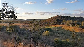
Chizarira National Park is a national park that lies in Northern part of Zimbabwe. At 2,000 square kilometres, it is the third-largest national park in Zimbabwe, and also one of the least known because of its isolated situation on the Zambezi Escarpment. It has good wildlife populations and some majestic scenery. The name of the park comes from the Batonga word chijalila, which translates into English as "great barrier", referring to Zambezi Escarpment, of which Chizarira’s rough terrain forms a part.

The Luangwa River is one of the major tributaries of the Zambezi River, and one of the four biggest rivers of Zambia. The river generally floods in the rainy season and then falls considerably in the dry season. It is one of the biggest unaltered rivers in Southern Africa and the 52,000 square kilometres (20,000 sq mi) that make up the surrounding valley are home to abundant wildlife.

The Peace–Athabasca Delta, located in northeast Alberta, is the largest freshwater inland river delta in North America. It is located partially within the southeast corner of Wood Buffalo National Park, Canada's largest national park, and also spreads into the Regional Municipality of Wood Buffalo, west and south of the historical community of Fort Chipewyan. The delta encompasses approximately 321,200 ha, formed where the Peace and Athabasca rivers converge on the Slave River and Lake Athabasca. The delta region is designated a wetland of international importance and a UNESCO World Heritage Site. The region is large enough that it is considered one of twenty distinct natural subregions of Alberta by the provincial government's Natural Regions Committee.

Mosi-oa-Tunya National Park is a UNESCO World Heritage Site that is home to one-half of the Mosi-oa-Tunya—"The Smoke that Thunders", known worldwide as Victoria Falls—on the Zambezi River. The river forms the border between Zambia and Zimbabwe, so the falls are shared by the two countries, and the park is twin to the Victoria Falls National Park on the Zimbabwean side.

The Lower Zambezi National Park lies on the north bank of the Zambezi River in southeastern Zambia. Until 1983 when the area was declared a national park, the area was the private game reserve of Zambia's president. This meant that the park was protected from mass tourism and now remains one of the few untouched wilderness areas left in Africa. On the opposite bank is Zimbabwe's Mana Pools National Park. The two parks sit on the Zambezi floodplain ringed by mountains. The area is a UNESCO World Heritage Site.

Zambezi Escarpment is a name used for the escarpments forming both sides of the rift valley or graben in which lie the middle Zambezi river and Lake Kariba. They are fault scarps, rising 500 to 600 m higher than the lake or river, running from the Batoka Gorge roughly 800 km to the lower Zambezi, and facing each other about 50 to 100 km apart, closer in the west and opening up in the east.

The wildlife of Zimbabwe occurs foremost in remote or rugged terrain, in national parks and private wildlife ranches, in miombo woodlands and thorny acacia or kopje. The prominent wild fauna includes African buffalo, African bush elephant, black rhinoceros, southern giraffe, African leopard, lion, plains zebra, and several antelope species.

The Manas River, known in Bhutan as the Drangme Chhu, is a transboundary river in the Himalayan foothills between southern Bhutan, India, and China. It is the largest of Bhutan's four major river systems, with the other three being the Amo Chu or Torsa River, the Wang Chu or Raidak, and the Puna Tshang Chu or Sankosh. It is met by three other major streams before it again debouches into India in western Assam. The river flows for a total length of 400 kilometres (250 mi), including through Tibet for 24 km (15 mi), Bhutan for 272 kilometres (169 mi), and Assam for 104 kilometres (65 mi) before it joins the mighty Brahmaputra River at Jogighopa. A major tributary of the Manas, the Aie River, joins it in Assam at Bangpari.

The Zambezian flooded grasslands is an ecoregion of southern and eastern Africa that is rich in wildlife.
Zambia, officially known as the Republic of Zambia, is a landlocked country in Southern Africa. The neighbouring countries are the Democratic Republic of the Congo to the north, Tanzania to the north-east, Malawi to the east, Mozambique, Zimbabwe, Botswana, and Namibia to the south, and Angola to the west. The capital city is Lusaka, located in the southeast of the country. The population is concentrated mainly around the capital and the Copperbelt to the northwest.
Kavango–Zambezi Transfrontier Conservation Area is the second-largest nature and landscape conservation area in the world, spanning the international borders of five countries in Southern Africa. It includes a major part of the Upper Zambezi River and Okavango basins and Delta, the Caprivi Strip of Namibia, the southeastern part of Angola, southwestern Zambia, the northern wildlands of Botswana and western Zimbabwe. The centre of this area is at the confluence of the Zambezi and Chobe Rivers where the borders of Botswana, Namibia, Zambia and Zimbabwe meet. It incorporates a number of notable national parks and nature sites, including Chobe National Park, Hwange National Park, and the Victoria Falls. The region is home to a population of approximately 250,000 animals, including the largest population of African Elephants in the world.

The Zambezian and mopane woodlands is a tropical and subtropical grasslands, savannas, and shrublands ecoregion of southeastern Africa.
The proposed Batoka Gorge Hydroelectric Power Station is a 2400 MW hydroelectric power station, planned for the Zambezi River on the international border between Zambia and Zimbabwe.
The Peace Park Foundation, founded in 1997 by Dr Anton Rupert, President Nelson Mandela and Prince Bernhard of the Netherlands, is an organisation that aims to re-establish, renew and conserve large ecosystems in Africa, transcending man-made boundaries by creating regionally integrated and sustainably managed networks of Transfrontier Conservation Areas (TFCAs). Peace Parks Foundation has been involved in the establishment and development of ten of the 18 TFCAs found throughout southern Africa, all of which are in various stages of development. The establishment of each TFCA, or peace park, is complex and far-reaching, and involves several phases of activity, which can take many years to achieve.