
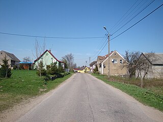
Spaulding is a village in Sangamon County, Illinois, United States. The population was 559 at the 2000 census. It is part of the Springfield, Illinois Metropolitan Statistical Area. Spaulding is in the Riverton School District #14.
Močiar is a village and municipality in Banská Štiavnica District, in the Banská Bystrica Region of Slovakia.
Potasznia is a village in the administrative district of Gmina Milicz, within Milicz County, Lower Silesian Voivodeship, in south-western Poland. Prior to 1945 it was in Germany.
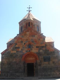
Arevshat is a village in the Ararat province of Armenia.
Tarnówko is a village in the administrative district of Gmina Kruszwica, within Inowrocław County, Kuyavian-Pomeranian Voivodeship, in north-central Poland.

Gołąbek is a village in the administrative district of Gmina Cekcyn, within Tuchola County, Kuyavian-Pomeranian Voivodeship, in north-central Poland. It lies approximately 7 kilometres (4 mi) north-west of Cekcyn, 8 km (5 mi) east of Tuchola, and 56 km (35 mi) north of Bydgoszcz.
Mostowlany-Kolonia is a village in an administrative district of Gmina Michałowo, within Białystok County, Podlaskie Voivodeship, in north-eastern Poland, close to the border with Belarus.

Skierwiny is a village in the administrative district of Gmina Drohiczyn, within Siemiatycze County, Podlaskie Voivodeship, in north-eastern Poland. It lies approximately 10 kilometres (6 mi) north of Drohiczyn, 18 km (11 mi) west of Siemiatycze, and 80 km (50 mi) south-west of the regional capital Białystok.
Twarogi-Trąbnica is a village in the administrative district of Gmina Perlejewo, within Siemiatycze County, Podlaskie Voivodeship, in north-eastern Poland.

Şəfibəyli is a village in the Zangilan Rayon of Azerbaijan.
Kürdəmir is a village in the Zaqatala Rayon of Azerbaijan. The village forms part of the municipality of Bəhmətli.
Niskowa is a village in the administrative district of Gmina Chełmiec, within Nowy Sącz County, Lesser Poland Voivodeship, in southern Poland. It lies approximately 3 kilometres (2 mi) south-west of Chełmiec, 5 km (3 mi) west of Nowy Sącz, and 71 km (44 mi) south-east of the regional capital Kraków.
Humięcino-Koski is a village in the administrative district of Gmina Grudusk, within Ciechanów County, Masovian Voivodeship, in east-central Poland.
Leontyna is a village in the administrative district of Gmina Jakubów, within Mińsk County, Masovian Voivodeship, in east-central Poland. It lies approximately 5 kilometres (3 mi) west of Jakubów, 6 km (4 mi) north-east of Mińsk Mazowiecki, and 42 km (26 mi) east of Warsaw.

Wolinia is a village in the administrative district of Gmina Główczyce, within Słupsk County, Pomeranian Voivodeship, in northern Poland. It lies approximately 11 kilometres (7 mi) east of Główczyce, 37 km (23 mi) north-east of Słupsk, and 76 km (47 mi) west of the regional capital Gdańsk.
Błąkały is a village in the administrative district of Gmina Dubeninki, within Gołdap County, Warmian-Masurian Voivodeship, in northern Poland, close to the border with the Kaliningrad Oblast of Russia. It lies approximately 4 kilometres (2 mi) east of Dubeninki, 21 km (13 mi) east of Gołdap, and 150 km (93 mi) east of the regional capital Olsztyn.

Sinošević is a village in the municipality of Šabac, Serbia. According to the 2002 census, the village has a population of 918 people.

Sudići (Ilijaš) is a village in the municipality of Ilijaš, Bosnia and Herzegovina.
Imamovići is a village in the municipality of Sokolac, Bosnia and Herzegovina.

Gustav Adolf Land is the land area of the southwestern part of Nordaustlandet, Svalbard, south of Wahlenbergfjorden. The area is named after Gustaf VI Adolf of Sweden.


