
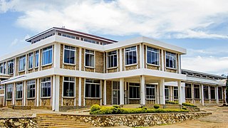
Iringa is a city in Tanzania with a population of 202,490 and situated at a latitude of 7.77°S and longitude of 35.69°E. The name is derived from the Hehe word lilinga, meaning fort. Iringa is the administrative capital of Iringa Region. Iringa Municipal Council is the administrative designation of the Municipality of Iringa. Iringa has been one of the coldest regions in Tanzania due to its geographical location but that has attracted a lot of tourists from colder regions abroad especially Western Europe. Iringa also hosts one of Africa’s largest national parks the Ruaha National Park.

Pwani Region is one of Tanzania's 31 administrative regions. The word "Pwani" in Swahili means the "coast". The regional capital is the town of Kibaha. The Region borders the Tanga Region to the north, Morogoro Region to the west, Lindi Region to the south, and surrounds Dar es Salaam Region to the east. The Indian Ocean also borders the region to its northeast and southeast. The region is home to Mafia Island, the Rufiji delta and Saadani National Park. The region is home to Bagamoyo town, a historical Swahili settlement, and the first colonial capital of German East Africa. According to the 2012 national census, the region had a population of 1,098,668, which was slightly lower than the pre-census projection of 1,110,917. From 2002 to 2012, the region's 2.2 percent average annual population growth rate was the seventeenth-highest in the country. It was also the 21st most densely populated region with 34 people per square kilometre., the region is slightly larger than Belgium.
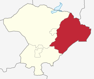
Iringa Region is one of Tanzania's 31 administrative regions. The region covers an area of 35,503 km2 (13,708 sq mi). The region is comparable in size to the combined land area of the nation state of Guinea Bissau. Iringa Region is bordered to the east by Morogoro Region and south by Njombe Region. On the west the region is bordered by Mbeya Region. Dodoma Region and Singida Region border Iringa on the north. The regional capital is the city Iringa for which the city is named after. According to the 2012 census, the region has a total population of 941,238. Iringa Region is home to Ruaha National Park, Tanzania's second national largest park.
Kilolo is one of the four districts of the Iringa Region of Tanzania. It is bordered to the north and east by the Morogoro Region, to the south by Mufindi District and to the west by the Iringa Rural District. The district is home to the Udzungwa Mountains National Park.

Mufindi District is one of the four districts of the Iringa Region of Tanzania. It is bordered to the north by Kilolo District and Iringa Urban District, to the south by the Njombe Region, to the east by the Morogoro Region and to the west by the Singida Region.

Njombe District is a former district of the Iringa Region of Tanzania. The current Njombe districts are Njombe Rural District and Njombe Urban District.

Iringa Rural District is one of the four districts of the Iringa Region of Tanzania, East Africa. It is bordered to the north by the Dodoma Region, to the east by Kilolo District and encircles Iringa Urban District, to the south by the Mufindi District, to the southwest by the Mbeya Region and to the northwest by the Singida Region.

The following outline is provided as an overview of and topical guide to Tanzania:
Malangali, Mufindi is an administrative ward in the Mufindi District of the Iringa Region of Tanzania, East Africa. In 2016 the Tanzania National Bureau of Statistics report there were 6,120 people in the ward, from 5,849 in 2012.

Mpwapwa District is one of the seven districts of the Dodoma Region of Tanzania. It is bordered to the north by Kongwa District, to the east by Morogoro Region, to the south by Iringa Region, and to the west by Chamwino District. Its district capital is the town of Mpwapwa.
Kalenga is an administrative ward in the Iringa Rural district of the Iringa Region of Tanzania. In 2016 the Tanzania National Bureau of Statistics reported its population to be 7,286, up from 6,963 in 2012.
Makambako is a medium-sized town and district in the Njombe Region of the Tanzanian Southern Highlands, located roughly 40 miles north of Njombe city by road. It is located at junction of the A104 and B4 roads between Njombe, Iringa, and Mbeya. Its population according to the 2002 Tanzanian census was 51,049.
Matola is a town and ward in Njombe district in the Iringa Region of the Tanzanian Southern Highlands. Its population according to the 2002 Tanzanian census is 14,106.
Wanging'ombe is a town and ward in Wanging'ombe District in the Njombe Region of the Tanzanian Southern Highlands. As of 2002, the population of the ward was 18,545.
Ludewa is a town and ward in Ludewa District of Njombe Region in Tanzania, East Africa. The town is the administrative seat for Ludewa District. As of the 2002 census, the ward had a population of 8,747.

Mninga is an administrative ward in the Mufindi District of the Iringa Region of Tanzania, East Africa.
Mwenga Dam is a hydroelectric dam in Tanzania, located in the Iringa Region. Its installed capacity is 4 megawatts (5,400 hp). The Power plant is operated by an Independent Power Producer, Rift Valley Energy.
