Kigali is the capital and largest city of Rwanda. It is near the nation's geographic centre in a region of rolling hills, with a series of valleys and ridges joined by steep slopes. As a primate city, Kigali is a relatively new city. It has been Rwanda's economic, cultural, and transport hub since it was founded as an administrative outpost in 1907, and became the capital of the country at independence in 1962, shifting focus away from Huye.

Ruhengeri, also known as Musanze or Muhoza, is the third largest city in Rwanda and the capital of Musanze District in the Northern Province of Rwanda. The city has a population of 153,368 as of the 2022 census.
Rwamagana is a city and capital of both the Rwamagana District and the Eastern Province in Rwanda
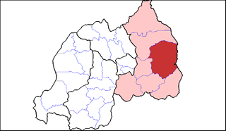
The five provinces of Rwanda are divided into 30 districts. Each district is in turn divided into sectors, which are in turn divided into cells, which are in turn divided into villages.

Nyagatare is the largest and second most populous district (akarere) in Rwanda. Located in Eastern Province, Rwanda, it occupies the northeastern extremity of Rwanda. Its capital is Nyagatare City, the former capital of the now defunct Umutara province. Nyagatare District borders Uganda in the North, Tanzania in the East, Gatsibo District of the in the South, and Gicumbi District of the Northern Province in the West. Nyagatare has an area of 1741 km2, what makes it the largest district in Rwanda. With a population of 466,944 in 2012, and 653,861 in 2023, Nyagatare is the second most populated district of Rwanda only after Gasabo District of Kigali City with 879,505 inhabitants. This is a 156% increase from 2002 when the population was only 255,104. This sharp rise in the population is mainly due to the major movement of the population from other parts of the country in search of land.
Kayonza is a district (akarere) located in Eastern Province, Rwanda. Its capital is Mukarange.The population of Kayonza District is projected to 457,156 people in 2022, living in 12 sectors (imirenge): Gahini, Kabare, Kabarondo, Mukarange, Murama, Murundi, Mwiri, Ndego, Nyamirama, Rukara, Ruramira and Rwinkwavu., and 50 cells and 421 Villages (Imidugudu).

Rwamagana is a district (akarere) in Eastern Province, Rwanda. Its capital is Rwamagana city, which is also the provincial capital.it has 14 sectors which are Gishali,fumbwe,mwurire, Kigabiro,...it is found in eastern province of Rwanda.muri Rwamagana harimo ibikorwa remezo nka IPRC gishari, gishari health center, RNP police training school,Lake Muhazi.

Rulindo is a district (akarere) in Northern Province, Rwanda. Its capital is Tare.
Musanze is a district in the Northern Province of Rwanda. Its capital city is Ruhengeri.
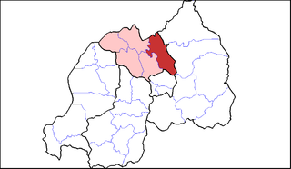
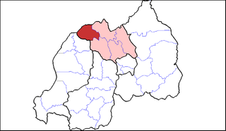
Gicumbi is a district (akarere) in Northern Province, Rwanda. Its capital is Byumba, which is also the provincial capital.

Burera is a district (Akarere) in Northern Province, Rwanda. Its capital is Cyeru.

Gasabo is a district (akarere) in Kigali city, the capital of Rwanda. The headquarter of Gasabo is located in Remera Sector. The district also includes large areas of the city itself, including Kacyiru, Kimironko, Remera, Nyarutarama and Kimihurura.

Kicukiro District is one of the three Districts which constitute the City of Kigali and is situated in the South-East of the City of Kigali. Is a district (akarere) located in Kigali Province, Rwanda. Kicukiro is home to a thriving market, a number of NGOs(Non-Government Organizations) and the Bralirwa Brewery. In addition, it is the headquarters for the Friends Church in Rwanda. Kicukiro District is also home to two major memorial sites associated with the Rwandan genocide. These are the Rebero Genocide Memorial Site where 14,400 victims are buried, and the Nyanza Genocide Memorial Site where 5,000 victims were killed after Belgian soldiers who were serving in the United Nations peacekeeping forces abandoned them.

Nyarugenge is a district (akarere) in Kigali Province, Rwanda. Its heart is the city centre of Kigali, and contains most of the city's businesses.

Rubavu District is one of the seven districts (akarere) in Western Province, Rwanda, with a total surface area of 388.4 km2. Its capital is Gisenyi, a large beach resort and border city. The Rubavu Urban area, which includes Gisenyi, Rugerero and other nearby localities, had a 2012 population of 149,209, the second most populous urban area in Rwanda.

Rutsiro is a district (akarere) in Western Province, Rwanda. Its headquarter is located in Gihango sector.

Gatsibo is a district (akarere) in Eastern Province, Rwanda. Its capital is Kabarore. It lies in the sectors of Gatsibo and Kageyo. It’s at about 1 hour and 50 minutes drive from Kigali city.

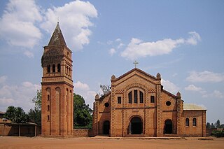
Gahini is a sector and village in Kayonza District, Eastern Province, Rwanda. It is situated on a hill, at an altitude of 1,520 metres (4,990 ft) above sea-level, close to the eastern edge of Lake Muhazi and 73 kilometres (45 mi) by road from the capital, Kigali. The village is the centre of one of the nine dioceses of the Eglise Episcopale au Rwanda, the Anglican church of Rwanda, and one of the four Rwandan sites chosen by the Church Missionary Society, who built a large mission, hospital and schools in the village.

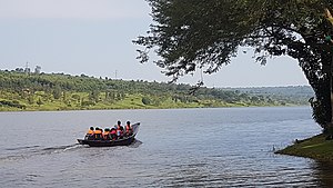
Lake Muhazi is a long thin shallow lake in the east of Rwanda. The bulk of the lake lies in the Eastern Province, with the western end forming the border between the Northern and Kigali Provinces. It is a flooded valley lake, lying predominantly in an east to west direction, but with numerous offshoots in a north to south direction, formerly the location of tributaries. The lake has a concrete dam at the western end, constructed in 1999 to replace an earth dam which had existed since time immemorial. The lake empties into the Nyabugogo River, which flows southwards to Kigali where it meets the Nyabarongo River, part of the upper Nile.
Kabarore is a sector and town in Rwanda. It is the headquarters of Gatsibo District.