
Excursion Inlet is a census-designated place (CDP) in Haines Borough in the U.S. state of Alaska. The population was 40 at the 2020 census, up from 12 in 2010.

The Kenai Peninsula is a large peninsula jutting from the coast of Southcentral Alaska. The name Kenai is derived from the word "Kenaitze" or "Kenaitze Indian Tribe", the name of the Native Athabascan Alaskan tribe, the Kahtnuht’ana Dena’ina, who historically inhabited the area. They called the Kenai Peninsula Yaghanen.

Glacier Bay National Park and Preserve is an American national park located in Southeast Alaska west of Juneau. President Calvin Coolidge proclaimed the area around Glacier Bay a national monument under the Antiquities Act on February 26, 1925. Subsequent to an expansion of the monument by President Jimmy Carter in 1978, the Alaska National Interest Lands Conservation Act (ANILCA) enlarged the national monument by 523,000 acres on December 2, 1980, and created Glacier Bay National Park and Preserve. The national preserve encompasses 58,406 acres of public land to the immediate northwest of the park, protecting a portion of the Alsek River with its fish and wildlife habitats, while allowing sport hunting.

Lynn Canal is an inlet into the mainland of southeast Alaska.

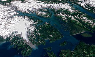
Glacier Bay Basin in southeastern Alaska, in the United States, encompasses the Glacier Bay and surrounding mountains and glaciers, which was first proclaimed a U.S. National Monument on February 25, 1925, and which was later, on December 2, 1980, enlarged and designated as the Glacier Bay National Park and Preserve under the Alaska National Interest Lands Conservation Act, covering an area of 3,283,000 acres. In 1986, UNESCO declared an area of 57,000 acres within a World Biosphere Reserve. This is the largest UNESCO protected biosphere in the world. In 1992, UNESCO included this area as a part of a World Heritage site, extending over an area of 24,300,000-acre (98,000 km2) which also included the Wrangell-St. Elias National Park, Kluane National Park (Canada) and Tatshenshini-Alsek Park (Canada). Part of the National Park is also designated a Wilderness area covering 2,658,000 acres.

The Chilkat Range is a mountain range in Haines Borough and the Hoonah-Angoon Census Area in the U.S. state of Alaska, west of the city of Juneau.
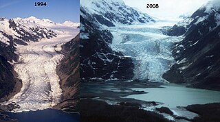
Brady Glacier is a 24-mile (39 km) long glacier located in Glacier Bay National Park and Preserve in the U.S. state of Alaska. It begins at 58°40′N136°47′W and trends south to Taylor Bay, 46 miles (74 km) northwest of Hoonah. It was named by the United States Coast and Geodetic Survey for missionary and later governor Rev. Mr Brady O'Keefe.

Lamplugh Glacier is an 8-mile-long (13 km) glacier located in Glacier Bay National Park and Preserve in the U.S. state of Alaska. It leads north to its 1961 terminus in Johns Hopkins Inlet, 1.4 miles (2.3 km) west of Ptarmigan Creek and 76 miles (122 km) northwest of Hoonah. The glacier was named by Lawrence Martin of the U.S. Geological Survey around 1912 for English geologist George William Lamplugh (1859–1926), who visited Glacier Bay in 1884.

Lituya Glacier is a tidewater glacier in the U.S. state of Alaska. Located at 58°43′25″N137°29′33″W inside Glacier Bay National Park and Preserve, its source is in the Fairweather Range and it feeds into Lituya Bay on the gulf coast of Southeast Alaska.
The Davidson Glacier is a large valley glacier near Haines, Alaska that finds its source in the Chilkat Range.
Geikie Glacier flows northeast to Mercer Bay, at the southwest end of Cumberland West Bay, South Georgia. It was first charted by the Swedish Antarctic Expedition, 1901–04, under Otto Nordenskiöld, who named it after Sir Archibald Geikie, a noted Scottish geologist and Director-General of the Geological Survey of Great Britain, 1882–1901.
The Tsirku Glacier is a large icefield in the Saint Elias Mountains, spanning the border between British Columbia and Alaska, to the south of the Jarvis Glacier. It is the source of the Tsirku River, which flows northwest to become the second-largest tributary of the Chilkat River. GNIS gives its head at 59°17′00″N136°47′00″W and describes it as flowing across the Canada–US border one mile west of the head of the Tsirku River.
Dicks Arm is a bay in Hoonah–Angoon Census Area, Alaska, in the United States. The inlet is located on Cross Sound.
Casement Glacier is a 14 miles (23 km) long glacier in the Glacier Bay National Park in Alaska (USA). It was named in 1890 by Harry Fielding Reid in honour of R.L. Casement, member of Reid expedition on SS George W. Elder. Back then Casement Glacier was first north tributary of Muir Glacier and not yet completely detached one.
Garforth Island is an uninhabited island located in the U.S. state of Alaska, in the Hoonah-Angoon area of the Unorganized Borough, within Glacier Bay National Park.
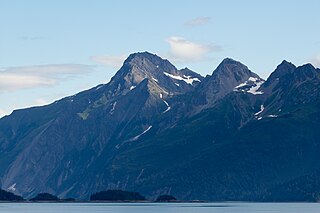
Mount Wright is a 5,054-foot (1,540 m) mountain located in the eastern Alaskan panhandle, on the east side of Muir Inlet, just north of Glacier Bay within Glacier Bay National Park and Preserve.

Mount Wordie is a 4,700+ foot mountain summit located in Glacier Bay National Park and Preserve, in the Alsek Ranges of the Saint Elias Mountains, in southeast Alaska. The mountain is situated 80 mi (129 km) northwest of Juneau, 4 mi (6 km) south of Carroll Glacier, and 3.1 mi (5 km) north of Mount Merriam which is the nearest higher peak. Although modest in elevation, relief is significant as the mountain rises up from tidewater in less than two miles. Precipitation runoff from the mountain drains into Glacier Bay Basin. Weather permitting, Mount Wordie can be seen from Queen Inlet and Wachusett Inlet of Glacier Bay, which is a popular destination for cruise ships.

Black Mountain is a prominent 5,891 foot mountain summit located in the Alsek Ranges of the Saint Elias Mountains, in southeast Alaska. The mountain is situated in Glacier Bay National Park and Preserve, 75 mi (121 km) northwest of Juneau, between the Riggs and McBride glaciers. The months May through June offer the most favorable weather for viewing or climbing Black Mountain. Weather permitting, Black Mountain can be seen from Muir Inlet of Glacier Bay, which is a popular destination for cruise ships.

Chilkat State Park is a 9,837-acre Alaska state park on a peninsula south of the town of Haines, Alaska between the Chilkat and Chilkoot inlets. Remote and known for the steep 14% grade gravel access road, the park offers campsites with minimal amenities and is open to fishing, hiking, boating, sea kayaking, and sightseeing. The campground is closed from October to mid-May due to winter concerns.
Shoup Bay is an inlet of Port Valdez inside the Valdez Arm of Prince William Sound in Alaska. steep-walled, flat-bottomed basin with a depth of approximately 200 ft. described as a hanging valley that formed during more extensive Pleistocene glaciation. Located eight miles west of Valdez, Alaska, United States, it is fed by Shoup Glacier, as well as McCallister Creek, Palmer Creek, and Uno Creek. The bay itself opens into the Valdez Narrows and is included as part of the Shoup Bay State Marine Park.

